The Leicestershire and Rutland Wildlife Trust (LRWT) is one of 46 wildlife trusts across the United Kingdom. It manages nature reserves in Leicestershire and Rutland, and was founded in 1956 as the Leicestershire and Rutland Trust for Nature Conservation. As of January 2018, it has over 16,000 members, a staff of about 25 and more than 500 volunteers. It is based in Leicester, and is managed by a Council of Trustees which is elected by the members. It is a charity which covers all aspects of nature conservation, and works to protect wild places and wildlife.
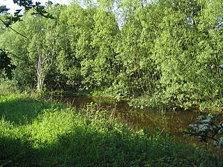
Flitwick Moor is a 59.8-hectare (148-acre) biological Site of Special Scientific Interest between Flitwick and Greenfield in Bedfordshire. It was notified under Section 28 of the Wildlife and Countryside Act 1981 in 1984 and the local planning authority is Central Bedfordshire Council. The site is managed by the Wildlife Trust for Bedfordshire, Cambridgeshire and Northamptonshire.

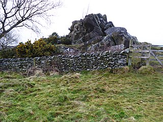
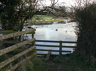
Bloody Oaks Quarry is a 1.3-hectare (3.2-acre) biological Site of Special Scientific Interest north-west of Great Casterton in Rutland. It is owned and managed by the Leicestershire and Rutland Wildlife Trust.

Charnwood Lodge is a 134.2-hectare (332-acre) biological and geological Site of Special Scientific Interest in Charnwood Forest, east of Coalville in Leicestershire. It is a national nature reserve, and contains two Geological Conservation Review sites. It is managed by the Leicestershire and Rutland Wildlife Trust.

Dimminsdale is a 37 hectare geological biological and Site of Special Scientific Interest partly in Derbyshire and partly in Leicestershire. It is located east of Calke in Derbyshire. It is a Geological Conservation Review site, and a area of 23.5 hectares is owned by Severn Trent Water and managed by the Leicestershire and Rutland Wildlife Trust.

Ketton Quarries is a 115.6-hectare (286-acre) biological and geological Site of Special Scientific Interest east of Ketton in Rutland. It is a Geological Conservation Review site, and an area of 27.5 hectares is managed by the Leicestershire and Rutland Wildlife Trust.
Launde Big Wood is a 41.1 hectares biological Site of Special Scientific Interest east of Leicester. It is part of Launde Woods nature reserve, which is owned by the Leicester Diocesan Board of Finance and managed by the Leicestershire and Rutland Wildlife Trust.
Loughborough Meadows is a 60.5 hectares biological Site of Special Scientific Interest on the northern outskirts of Loughborough in Leicestershire, England. An area of 35.3 hectares is managed as a nature reserve by the Leicestershire and Rutland Wildlife Trust.

Eye Brook Valley Woods is a 65.7-hectare (162-acre) biological Site of Special Scientific Interest east of Hallaton in Leicestershire. It is in three separate areas, Great Merrible Wood, which is managed by the Leicestershire and Rutland Wildlife Trust, Bolt Wood and Park Wood.

Great Merrible Wood is a 12 hectare nature reserve east of Hallaton in Leicestershire. It is owned and managed by the Leicestershire and Rutland Wildlife Trust, and is part of the Eye Brook Valley Woods Site of Special Scientific Interest.
Croft Pasture is a 6.2-hectare (15-acre) biological Site of Special Scientific Interest on the outskirts of Croft in Leicestershire. Most of the site, totalling 5.8 hectares, is owned and managed by the Leicestershire and Rutland Wildlife Trust.

Leighfield Forest SSSI is an 11.3 hectares biological Site of Special Scientific Interest east of Skeffington in Leicestershire, England. It consists of several fragments, including Tugby Wood, Loddington Reddish, Brown's Wood, Skeffington Wood and Tilton Wood, of the former medieval hunting Leighfield Forest, which straddles Leicestershire and Rutland. It is a Nature Conservation Review site, Grade II.

Stonesby Quarry is a 3.2 hectares biological Site of Special Scientific Interest between Stonesby and Waltham on the Wolds in Leicestershire. It is part of a 4 hectare nature reserve managed by the Leicestershire and Rutland Wildlife Trust.

Breedon Cloud Wood and Quarry is a 63.3 hectares biological and geological Site of Special Scientific Interest north-east of Worthington in Leicestershire. It is a Geological Conservation Review site. An area of 33 hectares is managed as a nature reserve by the Leicestershire and Rutland Wildlife Trust.

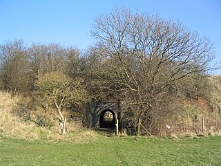
Tilton Cutting is a 4.4 hectares geological Site of Special Scientific Interest west of Tilton on the Hill in Leicestershire. It is a Geological Conservation Review site, and is owned and managed by the Leicestershire and Rutland Wildlife Trust as Tilton Railway Cutting.
Wymondham Rough is a 6.0 hectares biological Site of Special Scientific Interest (SSSI) east of Stapleford in Leicestershire. The SSSI is part of the 12.5 hectare Wymondham Rough nature reserve, which is managed by the Leicestershire and Rutland Wildlife Trust.

Ulverscroft Valley is a 110.8 hectares biological Site of Special Scientific Interest north-west of Markfield in Leicestershire. The site is in five separate blocks, and two areas are nature reserves managed by the Leicestershire and Rutland Wildlife Trust (LRWT). Lea Meadows is owned by the LRWT and it is also a scheduled monument. Part of Ulverscroft Nature Reserve is owned by the LRWT and part is owned by the National Trust and leased to the LRWT.

Ulverscroft is a 56-hectare (140-acre) nature reserve north of Markfield in Leicestershire, England. It is managed by the Leicestershire and Rutland Wildlife Trust (LRWT) and part of it is owned by the National Trust and part by the LRWT. The site is partly in Ulverscroft Valley, which is a Site of Special Scientific Interest.
