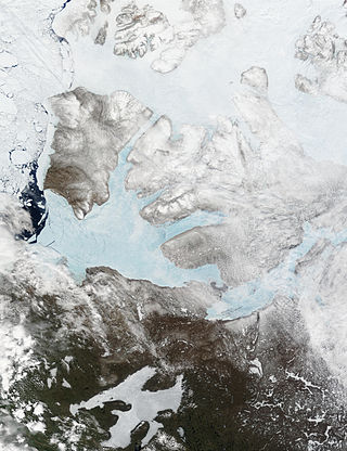
Banks Island is one of the larger members of the Arctic Archipelago. Situated in the Inuvik Region, and part of the Inuvialuit Settlement Region, of the Northwest Territories, it is separated from Victoria Island to its east by the Prince of Wales Strait and from the mainland by Amundsen Gulf to its south. The Beaufort Sea lies to its west, and to its northeast M'Clure Strait separates the island from Prince Patrick Island and Melville Island.

La Mauricie National Park is a national park located near Shawinigan in the Laurentian mountains, in the Mauricie region of Quebec, Canada. It covers 536 km2 (207 sq mi) in the southern Canadian Shield region bordering the Saint Lawrence lowlands. The park contains 150 lakes and many ponds.

Ukkusiksalik National Park is a national park in Nunavut, Canada. It covers 20,885 km2 (8,064 sq mi) of tundra and coastal mudflats south of the Arctic Circle and the hamlet of Naujaat, from Hudson Bay's Roes Welcome Sound towards the western Barrenlands and the source of Brown River. The park surrounds Wager Bay, a 100 km (62 mi)-long inlet on the Hudson Bay. Although the smallest of Nunavut's four national parks, it is the sixth largest in Canada. Its name relates to steatite found there: Ukkusiksalik means "where there is material for the stone pot".

The ciscoes are salmonid fish that differ from other members of the genus in having upper and lower jaws of approximately equal length and high gill raker counts. These species have been the focus of much study recently, as researchers have sought to determine the relationships among species that appear to have evolved very recently. The term cisco is also specifically used of the North American species Coregonus artedi, also known as lake herring.

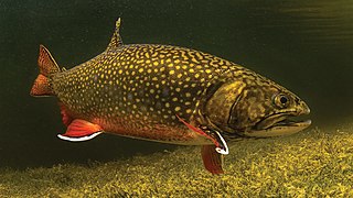
The brook trout is a species of freshwater fish in the char genus Salvelinus of the salmon family Salmonidae. It is native to Eastern North America in the United States and Canada, but has been introduced elsewhere in North America, as well as to Iceland, Europe, and Asia. In parts of its range, it is also known as the eastern brook trout, speckled trout, brook charr, squaretail, brookie or mud trout, among others. A potamodromous population in Lake Superior, as well as an anadromous population in Maine, is known as coaster trout or, simply, as coasters. The brook trout is the state fish of nine U.S. states: Michigan, New Hampshire, New Jersey, New York, North Carolina, Pennsylvania, Vermont, Virginia, and West Virginia, and the Provincial Fish of Nova Scotia in Canada.

The Arctic char or Arctic charr is a cold-water fish in the family Salmonidae, native to alpine lakes and arctic and subarctic coastal waters. Its distribution is Circumpolar North. It spawns in freshwater and populations can be lacustrine, riverine, or anadromous, where they return from the ocean to their fresh water birth rivers to spawn. No other freshwater fish is found as far north; it is, for instance, the only fish species in Lake Hazen which extend up to 81°56′N68°55′W on Ellesmere Island in the Canadian Arctic. It is one of the rarest fish species in Great Britain and Ireland, found mainly in deep, cold, glacial lakes, and is at risk there from acidification. In other parts of its range, such as the Nordic countries, it is much more common, and is fished extensively. In Siberia, it is known as golets and it has been introduced in lakes where it sometimes threatens less hardy endemic species, such as the small-mouth char and the long-finned char in Elgygytgyn Lake.

The Dolly Varden trout is a species of salmonid fish native to cold-water tributaries of the Pacific Ocean in Asia and North America. It belongs to the genus Salvelinus, or true chars, which includes 51 recognized species, the most prominent being the brook, lake and bull trout, as well as Arctic char. Although many populations are semi-anadromous, fluvial and lacustrine populations occur throughout its range. It is considered by taxonomists as part of the Salvelinus alpinus or Arctic char complex, as many populations of bull trout, Dolly Varden trout and Arctic char overlap.

Salvelinus is a genus of salmonid fish often called char or charr; some species are called "trout". Salvelinus is a member of the subfamily Salmoninae within the family Salmonidae. The genus has a northern circumpolar distribution, and most of its members are typically cold-water fish that primarily inhabit fresh waters. Many species also migrate to the sea.

Aulavik National Park ; from the Inuvialuktun for "place where people travel") is a national park located on Banks Island in the Northwest Territories of Canada. It is known for its access to the Thomsen River, one of the most northerly navigable rivers in North America. The park is a fly-in park, and protects approximately 12,274 square kilometres (4,739 sq mi) of Arctic Lowlands at the northern end of the island. The most practical way to visit the park is to charter a plane, and currently the park has four landing sites. Aulavik is considered a polar desert and often experiences high winds. Precipitation for the park is approximately 300 mm (12 in) per year. In the southern regions of the park a sparsely vegetated upland plateau reaches a height of 450 m (1,480 ft) above sea level.

Sachs Harbour is a hamlet located in the Inuvik Region of the Northwest Territories, Canada. Situated on the southwestern coast of Banks Island in the Inuvialuit Settlement Region, the population according to the 2021 census count was 103 people. Sachs Harbour is the only permanent settlement on Banks Island.

Arctic cisco, also known as omul Russian: Омуль, is an anadromous species of freshwater whitefish that inhabits the Arctic parts of Siberia, Alaska and Canada. It has a close freshwater relative in several lakes of Ireland, known as the pollan, alternatively regarded as conspecific with it, or as a distinct species.

The broad whitefish is a freshwater whitefish species. Dark silvery in colour, and like a herring in its shape, its distinctive features include a convex head, short gill rakers, and a mild overbite. It is found in the Arctic-draining streams, lakes, and rivers of far eastern Russia and North America. Its prey includes larval insects, snails, and shellfish. It is eaten by humans and brown bears.

Coregonus artedi, commonly known as the cisco, is a North American species of freshwater whitefish in the family Salmonidae. The number of species and definition of species limits in North American ciscoes is a matter of debate. Accordingly, Coregonus artedi may refer either in a narrow sense to one of the several types of cisco found e.g. in the Great Lakes, or in a broad sense to the complex of all ciscoes in continental North American lakes, Coregonus artedi sensu lato.

Hornaday River is a waterway located above the Arctic Circle on the mainland of Northern Canada.


