
Cloncurry is a rural town and locality in the Shire of Cloncurry, Queensland, Australia. It is informally known by local people as The Curry. In the 2021 census, the locality of Cloncurry had a population of 3,167 people.

Westwood is a town in the Rockhampton Region and a locality split between the Rockhampton Region and the Shire of Banana in Queensland, Australia. It was the first town that was gazetted by the Queensland Government. In the 2021 census, the locality of Westwood had a population of 199 people.

Dajarra is a town and a locality in the Shire of Cloncurry, Queensland, Australia. In the 2016 census, Dajarra had a population of 191 people; 60.3% of the population are Indigenous.
Mount Mulligan is a former mining town and now a rural locality in the Shire of Mareeba, Queensland, Australia. In the 2016 census Mount Mulligan had a population of 4 people.

Mount Molloy is a rural town and locality in the Shire of Mareeba, Queensland, Australia. It is a historic mining and timber town, 55 kilometres (34 mi) north of Cairns. The dominant industry in the area is cattle grazing; the town itself consists of a few shops and an old hotel. In the 2021 census, the locality of Mount Molloy had a population of 266 people.
Kynuna is an outback town in the Shire of McKinlay and a locality split between the Shire of McKinlay and the Shire of Winton in Queensland, Australia. In the 2016 census the locality of Kynuna had a population of 55 people.
Kajabbi is a rural town in the locality of Three Rivers, Shire of Cloncurry, Queensland, Australia.

Duchess is a rural town and locality in the Shire of Cloncurry, Queensland, Australia. In the 2016 census, Duchess had a population of 23 people.

Einasleigh is a town and a locality in the Shire of Etheridge, Queensland, Australia. In the 2016 census, the locality of Einasleigh had a population of 92 people.
Mount Cuthbert is a former copper mining town in the locality of Three Rivers, Shire of Cloncurry, Queensland, Australia. It is now a ghost town.

Palmer is a rural locality in the Shire of Cook, Queensland, Australia. In the 2021 census, Palmer had a population of 46 people.
Selwyn is a rural town and locality in the Shire of Cloncurry, Queensland, Australia. Selwyn is now an abandoned mining town. In the 2016 census the locality of Selwyn had a population of 50 people.
Nicholson is a coastal locality in the Shire of Burke, Queensland, Australia. It is on the border with the Northern Territory. In the 2021 census, Nicholson had a population of 32 people.
Bellevue is a rural locality in the Shire of Mareeba, Queensland, Australia. In the 2021 census, Bellevue had "no people or a very low population".
Crystalbrook is a rural locality in the Shire of Mareeba, Queensland, Australia. In the 2021 census, Crystalbrook had "no people or a very low population".
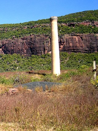
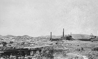
Kuridala is a former mining township and locality in the Shire of Cloncurry, Queensland, Australia. In the 2021 census, Kuridala had a population of 38 people.
Oakey Creek is a rural locality in the Rockhampton Region, Queensland, Australia. In the 2021 census, Oakey Creek had a population of 12 people.

Four Ways is an outback locality in the Shire of Cloncurry, Queensland, Australia. In the 2021 census, Four Ways had a population of 76 people.

Stokes is an outback locality in the Shire of Carpentaria, Queensland, Australia. In the 2021 census, Stokes had a population of 75 people.
Mount Mulgrave is a rural locality in the Shire of Mareeba, Queensland, Australia. In the 2021 census, Mount Mulgrave had a population of 11 people.
