Campbell County is a county in the U.S. state of South Dakota. As of the 2020 census, the population was 1,377, making it the fourth-least populous county in South Dakota. Its county seat is Mound City. The county was created in 1873 and organized in 1884. It was named for Norman B. Campbell, a Dakota Territory legislator in 1873 and son of General Charles T. Campbell.

Stark County is a county in the U.S. state of North Dakota. As of the 2020 census, the population was 33,646, making it the 7th most populous county in North Dakota. and was estimated to be 33,001 in 2023. Its county seat is Dickinson.

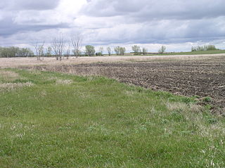
Oliver County is a county located in the U.S. state of North Dakota. As of the 2020 census, the population was 1,877. Its county seat and only city is Center.

Morton County is a county in the U.S. state of North Dakota. As of the 2020 census, the population was 33,291, making it the sixth most populous county in North Dakota. Its county seat is Mandan. Morton County is included in the Bismarck, ND, Metropolitan Statistical Area.
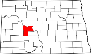
Mercer County is a county in the U.S. state of North Dakota. As of the 2020 census, the population was 8,350. Its county seat is Stanton.
Grant County is a county in the U.S. state of North Dakota. As of the 2020 census, the population was 2,301. Its county seat is Carson.

Cherry County is a county in the U.S. state of Nebraska. As of the 2020 United States Census, the population was 5,455. Its county seat is Valentine. The county was named for Lt. Samuel A. Cherry, an Army officer who was stationed at Fort Niobrara and was killed in South Dakota in 1881. Cherry County is in the Nebraska Sandhills. It is the state's largest county, at nearly 6,000 square miles (16,000 km2), larger than the state of Connecticut.
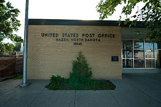
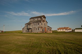
Hazen is a city in Mercer County, North Dakota, United States. The population was 2,281 at the 2020 census. Hazen was founded in 1913. Hazen has a K–12 school system.

Mandan is a city on the eastern border of Morton County and the eighth-most populous city in North Dakota. Founded in 1879 on the west side of the upper Missouri River, it was designated in 1881 as the county seat of Morton County. The population was 24,206 at the 2020 census. Across the Missouri River from Bismarck, Mandan is a core city of the Bismarck–Mandan Metropolitan Statistical Area.

The Mountain Time Zone of North America keeps time by subtracting seven hours from Coordinated Universal Time (UTC) when standard time (UTC−07:00) is in effect, and by subtracting six hours during daylight saving time (UTC−06:00). The clock time in this zone is based on the mean solar time at the 105th meridian west of the Greenwich Observatory. In the United States, the exact specification for the location of time zones and the dividing lines between zones is set forth in the Code of Federal Regulations at 49 CFR 71.
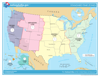
In the United States, time is divided into nine standard time zones covering the states, territories and other US possessions, with most of the country observing daylight saving time (DST) for approximately the spring, summer, and fall months. The time zone boundaries and DST observance are regulated by the Department of Transportation, but no single map of those existed until the agency announced intentions to make one in September 2022. Official and highly precise timekeeping services (clocks) are provided by two federal agencies: the National Institute of Standards and Technology (NIST) ; and the United States Naval Observatory (USNO). The clocks run by these services are kept synchronized with each other as well as with those of other international timekeeping organizations.

Turtle Mountain, or the Turtle Mountains, is an area in central North America, in the north-central portion of the U.S. state of North Dakota and southwestern portion of the Canadian province of Manitoba, approximately 62 miles (100 km) south of the city of Brandon on Manitoba Highway 10 / U.S. Route 281. It is a plateau 2,000 ft above sea level, 300 ft to 400 ft above the surrounding countryside, extending 20 mi (32 km) from north to south and 40 mi (64 km) from east to west. Rising 1,031 feet (314 m), North Dakota's most prominent peak, Boundary Butte, is located at the western edge of the plateau.

The tz database is a collaborative compilation of information about the world's time zones and rules for observing daylight saving time, primarily intended for use with computer programs and operating systems. Paul Eggert has been its editor and maintainer since 2005, with the organizational backing of ICANN. The tz database is also known as tzdata, the zoneinfo database or the IANA time zone database, and occasionally as the Olson database, referring to the founding contributor, Arthur David Olson.

The Regional designations of Montana vary widely within the U.S state of Montana. The state is a large geographical area that is split by the Continental Divide, resulting in watersheds draining into the Pacific Ocean, Gulf of Mexico and Hudson's Bay. The state is approximately 545 miles (877 km) east to west along the Canada–United States border and 320 miles (510 km) north to south. The fourth largest state in land area, it has been divided up in official and unofficial ways into a variety of regions. Additionally, Montana is part of a number of larger federal government administrative regions.

About 60% of Kentucky lies in the Eastern Time Zone, with the rest in the Central Time Zone, as follows:
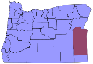
Time in Oregon is divided into two zones, with the vast majority in the Pacific Time Zone. Most of sparsely populated Malheur County, including its largest city, Ontario, and its county seat, Vale, are in the Mountain Time Zone due to their proximity to Boise, Idaho. The time zone division occurs at the southwest corner of township 35 S, range 37 E, continuing east to the state line, then south along the Oregon–Idaho border to the Nevada state line.
South Dakota lies in both the Mountain Time Zone and the Central Time Zone. Mountain Time contains most of the western half of the state, including Mount Rushmore. Rapid City is the largest city in the Mountain Time portion of the state. Central Time contains the eastern half of the state, including the state capital, Pierre, and the largest city in the Central Time portion of the state, Sioux Falls.
Current time for most counties: 13:01, January 16, 2025 CST [refresh]
Current time for El Paso and Hudspeth counties: 12:01, January 16, 2025 MST [refresh]
In North Macedonia, the standard time is Central European Time. Daylight saving time is observed from the last Sunday in March to the last Sunday in October. This is shared with several other EU member states.
