
Kauniainen is a small town and a municipality of 10,231 inhabitants in the Helsinki Metropolitan Area in Uusimaa, Finland. It is surrounded and enclaved by the City of Espoo, in the Capital Region of Greater Helsinki. Kauniainen was founded by a corporation in 1906, AB Grankulla, that parcelled land and created a suburb for villas; Kauniainen received the status of a market town in 1920, the Finnish name in 1949 and the title of kaupunki in 1972.
Tampere is a city in the Pirkanmaa region, located in the western part of Finland. Tampere is the most populous inland city in the Nordic countries. It has a population of 252,872; the urban area has a population of 341,696; and the metropolitan area, also known as the Tampere sub-region, has a population of 414,274 in an area of 4,970 km2 (1,920 sq mi). Tampere is the second largest urban area and the third most populous single municipality in Finland, after the cities of Helsinki and Espoo, and the most populous Finnish city outside the Helsinki Metropolitan Area. Today, Tampere is one of the most important urban, economic and cultural centres in the entire inland region.

Nokia is a town and municipality in southwestern Finland. It lies on the banks of the Nokianvirta River in the region of Pirkanmaa, about 15 kilometres (9 mi) west of Tampere. The distance to Tampere Airport from Nokia is 16 kilometres (9.9 mi) using road connections when circling Lake Pyhäjärvi. Its neighboring municipalities are Hämeenkyrö, Pirkkala, Sastamala, Tampere, Vesilahti and Ylöjärvi. As of 19 September 2023 it has a population of 35,595 and it is one of the fastest-growing cities in the area; today, Nokia is the 33rd largest municipality of Finland by population and the second largest municipality in Pirkanmaa after Tampere.
Pori is a city and municipality on the west coast of Finland. The city is located some 10 kilometres (6 mi) from the Gulf of Bothnia, on the estuary of the Kokemäki River, 110 kilometres (68 mi) west of Tampere, 140 kilometres (87 mi) north of Turku and 241 kilometres (150 mi) north-west of Helsinki, the capital of Finland. Pori was established in 1558 by Duke John, who later became King John III of Sweden.

Pirkkala is a municipality of Finland. It is located some 10 kilometres (6 mi) south-west from Tampere in the Pirkanmaa region. The municipality has a population of 20,644 and covers an area of 104.04 square kilometres (40.17 sq mi) of which 22.66 km2 (8.75 sq mi) is water. The population density is 253.67 inhabitants per square kilometre (657.0/sq mi), which makes it the most densely populated municipality in Finland that does not use the title of town or city. Pirkkala is also currently the fastest-growing municipality in the Pirkanmaa region. The municipality is unilingually Finnish.

Ylöjärvi is a town and a municipality in the Pirkanmaa region, 14 kilometres (9 mi) northwest of Tampere and 189 kilometres (117 mi) north of the capital city Helsinki in Finland. The town has a population of 33,731 and covers an area of 1,324.14 square kilometres (511.25 sq mi) of which 208.62 km2 (80.55 sq mi) is water. The population density is 30.24 inhabitants per square kilometre (78.3/sq mi).

Humppila is a municipality of Finland. It is located in the Tavastia Proper region. The municipality has a population of 2,139, which make it the smallest municipality in Tavastia Proper in terms of population. It covers an area of 148.61 square kilometres (57.38 sq mi) of which 0.65 km2 (0.25 sq mi) is water. The population density is 14.46 inhabitants per square kilometre (37.5/sq mi).

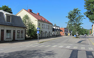
Hämeenkyrö is a municipality of Finland. It is part of the Pirkanmaa region, and is located 36 kilometres (22 mi) from Tampere. The municipality has a population of 10,310 and covers an area of 505.10 square kilometres (195.02 sq mi) of which 41.34 km2 (15.96 sq mi) is water. The population density is 22.23 inhabitants per square kilometre (57.6/sq mi).
Karkkila is a town and a municipality of Finland.
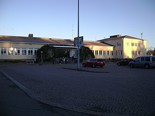
Riihimäki is a town and municipality in the south of Finland, about 69 kilometres (43 mi) north of Helsinki and 109 kilometres southeast of Tampere. An important railway junction is located in Riihimäki, since railway tracks from Riihimäki lead to Helsinki, Tampere and Lahti. Several businesses also operate in Riihimäki. Notably, Würth Oy has its Finnish headquarters and logistics center in Riihimäki. Valio has a major dairy in the Herajoki part of Riihimäki. The famous Sako rifles are also produced in Riihimäki. Riihimäki also has the second-highest flagpole in Finland.

Akaa is a town and a municipality in Pirkanmaa, Finland. It was created on January 1, 2007 when the town of Toijala and the municipality of Viiala were united into a single town. The municipality of Kylmäkoski was consolidated with Akaa on 1 January 2011.

Toijala railway station is located in the Toijala district of the town of Akaa, Finland.
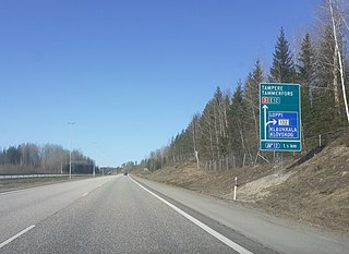
Finnish national road 3 is a highway in Finland between Helsinki and Vaasa via Hämeenlinna and Tampere. The road is 424 kilometres (263 mi) long and it is part of the European route E12. 180 kilometres (110 mi) of the highway is motorway, connecting Helsinki to Tampere. North of Tampere, the road is mostly two-lane road, with a share of 2+1 road. The busiest point on Highway 3 is in Helsinki, north of the Ring I junction, where the average traffic volume is about 90,000 vehicles per day.

Nokia Arena is an indoor arena in Tampere, Finland. It hosts ice hockey games, including the 2022 Men's World Championship, and large cultural events. It is also the home arena of Ilves and Tappara of the SM-liiga. Its construction was approved by the City Council of Tampere on 19 May 2010. The arena was officially opened on 3 December 2021.
The Tampere–Pori railway is a railway running between the cities of Tampere and Pori in Finland. The line carries passenger traffic from Tampere to Pori via five railway stations and continues as a freight line to the Port of Pori. Tampere–Pori railway was opened in 1895 and the line follows the river Kokemäenjoki.

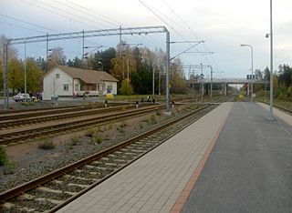
The Viiala railway station is located in the town of Akaa, Finland, in the urban area and district of Viiala. It is located along the Riihimäki–Tampere railway, and its neighboring stations are Lempäälä in the north and Toijala in the south.

The Vapriikki Museum Centre is a cluster of museums operating in the old factory premises of Tampella, in Tampere, Finland. The name Vapriikki derives from the Swedish word fabrik, meaning factory.
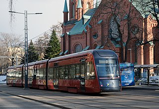
Transport in Tampere consists of car, bus, light rail and commuter rail services linking the city centre of Tampere, Finland to surrounding residential areas and towns in Pirkanmaa region. The system is managed by the Tampere Regional Transport Authority, branded as Nysse. The name originates from a local colloquialism nysse tulee, with nysse jokingly used to refer to any public transport vehicle.
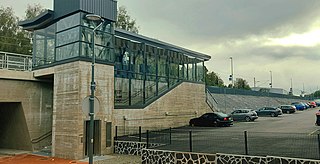
Tesoma railway station is a railway station in the Tesoma district in Tampere, Finland. The station opened on August 16 2021, with one track at first. The station is located on the Tampere–Pori railway between the track kilometres 196+080 and 196+370. It serves the Tampere commuter rail line M and long-distance traffic between Tampere and Pori. The trip from Tesoma to the Tampere railway station takes about 9 minutes. The location of the station is to the south of the Tesomajärvi shopping centre on the border of the districts of Ristimäki and Rahola.


