Santa Luzia is an island of the Barlavento archipelago in Cape Verde located between São Nicolau and São Vicente, the channel of Santa Luzia separates the island of São Vicente and is 8 km wide. The area is 34.2 km². Like all Cape Verdean islands, it is of volcanic origin. The highest point is Topona. Santa Luzia is 12.4 km long and 5.3 km wide.
Monte Verde is a mountain in the eastern part of the island of São Vicente, Cape Verde. At 744 m elevation, it is the island's highest point. The mountain is located 6 km (4 mi) east of the city centre of Mindelo.

Monte Penoso is a mountain on the island of Maio, Cape Verde. At 436 m elevation, it is the island highest point. It is situated in the eastern part of the island, 3 km southwest of Pedro Vaz and 13 km northeast of the island capital Porto Inglês. The mountain is of volcanic origin. It is part of the protected landscape Monte Penoso and Monte Branco, which covers 11.17 km2 (4.31 sq mi).

The Cruzinha Nature Reserve is a protected area in the northern part of the island of Santo Antão in the Cape Verde archipelago. It covers part of the north coast of the island, between the rivers Ribeira da Garça and the Ribeira do Mocho. It contains the only coastal dunes of Santo Antão. It takes its name from the village Cruzinha da Garça, part of the town Chã de Igreja.
Serra Negra is a hill in the southeastern part of the island of Sal in Cape Verde. Its maximum elevation is 104 m, the highest point in southern Sal. It stretches for about 2.5 km along the east coast of the island, between the headland Ponta da Fragata in the south and the Ponta do Morrinho Vermelho in the north. The nearest settlement is Murdeira, to the west. The mountain forms part of a protected area as a nature reserve, important as nesting area for seabirds and turtles. The nature reserve covers 3.31 km2 (1.28 sq mi) of land and 22.96 km2 (8.86 sq mi) of ocean.

Monte Grande is a mountain in the northern part of the island of Sal in Cape Verde. It is situated 8 km northeast of the island capital Espargos. At 406 m elevation, it is the highest point of the island. It is a protected landscape because of its geological value; the protected area covers 1,309 ha. There are pillow lava formations on the coast.
Rabo de Junco is a hill on the west coast of the island of Sal in Cape Verde. It is situated at the northern end of the Baía da Murdeira, 8 km southwest of the island capital Espargos. Its steep eroded south face towards the bay is an important nesting area for birds. Rabo de Junco and the surrounding area are protected as a nature reserve. It was mentioned as Rabadyunk in the 1747 map by Jacques-Nicolas Bellin. To its west lies the uninhabited islet Ilhéu Rabo de Junco.

Monte Trigo is the westernmost settlement on the island of Santo Antão, Cape Verde. It is situated on the coast, at the foot of the Tope de Coroa, the highest mountain of the island. It is 28 km west of the island capital Porto Novo. In 2010 its population was 274. About 5 km to the northwest is Ponta do Chão de Mangrade, the westernmost point of all Africa.
Morro is a settlement in the west of the island of Maio in Cape Verde. It is located 5 km north of the island capital Porto Inglês and 6 km south of Calheta. As of the 2010 census, its population was 310. The beach north of the village, Praia do Morro, is a 6.66 km2 nature reserve.

Xoxo is a settlement in the northeastern part of the island of Santo Antão in Cape Verde. It is situated 5 kilometres (3.1 mi) south of Ribeira Grande and 13 kilometres (8.1 mi) north of the island capital Porto Novo. The settlement lies in Cova-Paul-Ribeira da Torre Natural Park. The Ribeira da Torre flows through the settlement. The only road to Xoxo goes from Ribeira Grande through the Ribeira da Torre valley.

Cova-Paul-Ribeira da Torre Natural Park, in the east of the island of Santo Antão, is one of ten "natural parks" in the country of Cape Verde. Its area is 20.92 km2 (8.08 sq mi), of which 8.91 km2 (3.44 sq mi) in the municipality of Ribeira Grande, 8.85 km2 (3.42 sq mi) in the municipality of Paul and 3.16 km2 (1.22 sq mi) in the municipality of Porto Novo. Since 2016, the natural park is on the tentative list of World Heritage sites.
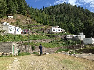
Pico da Cruz is a settlement in the northeastern part of the island of Santo Antão, Cape Verde. In 2010 its population was 138. It is situated 6 km southwest of Pombas and 10 km northeast of the island capital Porto Novo. Its elevation is about 1,400 meters. The village is named after the nearby mountain Pico da Cruz. It lies in the Cova-Paul-Ribeira da Torre Natural Park.
Moroços Natural Park, in the middle of the island of Santo Antão, is one of ten "natural parks" in Cape Verde. The protected area is 8.18 km2 (3.16 sq mi). It covers 7.46 km2 (2.88 sq mi) of the municipality of Ribeira Grande, and 0.71 km2 (0.27 sq mi) of Porto Novo.

Morrinho de Açúcar is a small hill in the northern part of the island of Sal in Cape Verde. It is situated 1 km from the north coast and 8 km north of the island capital Espargos. It is a remnant of a volcanic phonolitic chimney, surrounded by a vast plain. It is protected as a natural monument.
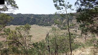
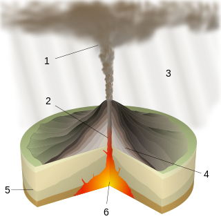
Cova is a volcanic caldera in the eastcentral part of the island of Santo Antão in Cape Verde. It is situated at the southwestern end of the municipality of Paul. Its lowest point is 1,166 meters, and the highest point of the crater rim is about 1,500 m. The diameter of the caldera is about 1.0 km. It forms a part of Cova-Paul-Ribeira da Torre Natural Park. The Cova formation dates from between 1.4 million and 700,000 years ago.
Ponta do Chão de Mangrade is the westernmost point of the Island of Santo Antão, and also the westernmost point of Cape Verde and all Africa. It is located 5 km northwest of Monte Trigo and 31 km west of Porto Novo, in a very remote area. The 1494 Treaty of Tordesillas divided the newly discovered lands outside Europe between Portugal and Spain along a meridian 370 leagues (2,193 km) west of this point.
Monte Tchota is a mountain located in the central part of Santiago Island in Cape Verde. Its elevation is 1,041 m. It is part of the Serra do Pico de Antónia Natural Park, and lies 1.5 km southeast of Pico de Antónia, the highest point of the island. The village Rui Vaz lies 3 km to the east.