
Abersychan is a settlement and community north of Pontypool in Torfaen, Wales, and lies within the boundaries of the historic county of Monmouthshire and the preserved county of Gwent.

The London boroughs are the 32 local authority districts that make up the Greater London county; each is governed by a London borough council. The London boroughs were all created at the same time as Greater London on 1 April 1965 by the London Government Act 1963 and are a type of local government district. Twelve were designated as Inner London boroughs and twenty as Outer London boroughs.

The Metropolitan Borough of Wirral is a metropolitan borough of Merseyside, in North West England. It has a population of 321,238, and encompasses 60 square miles (160 km2) of the northern part of the Wirral Peninsula. Major settlements include Birkenhead, Wallasey, Bebington, Heswall, Hoylake and West Kirby. The city of Liverpool over the Mersey, faces the northeastern side of Wirral. Bordering is the River Mersey to the east, the Irish Sea to the north and the River Dee to the west; the borough of Cheshire West and Chester occupies the remainder of the Wirral Peninsula and borders the borough of Wirral to the south. The borough of Wirral has greater proportions of rural areas than the Liverpool part of Merseyside.

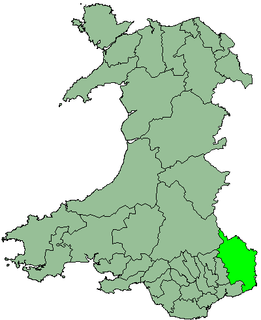
Blaenau Gwent is a county borough in Wales, sharing its name with a parliamentary constituency. It borders the unitary authority areas of Monmouthshire and Torfaen to the east, Caerphilly to the west and Powys to the north. Its main towns are Abertillery, Brynmawr, Ebbw Vale and Tredegar. Its highest point is Coity Mountain at 1,896 feet (578 m).

Bedford is a unitary authority area with borough status in the ceremonial county of Bedfordshire, England. Its council is based at Bedford, the county town of Bedfordshire. The borough contains one large urban area, the 71st largest in the United Kingdom that comprises Bedford and the adjacent town of Kempston, surrounded by a rural area with many villages. 75% of the borough's population live in the Bedford Urban Area and the five large villages which surround it, which makes up slightly less than 6% of the total land area of the Borough.

The Metropolitan Borough of Wigan is a metropolitan borough of Greater Manchester, in North West England. It is named after its largest component town and former county borough, Wigan and includes the towns and villages of Leigh, part of Ashton-in-Makerfield, Ince-in-Makerfield, Hindley, Orrell, Standish, Atherton, Tyldesley, Golborne, Lowton, Billinge, Astley, Haigh and Aspull. The borough was formed in 1974 and is an amalgamation of several former local government districts and parishes. The borough has three civil parishes and lies directly to the west of the City of Salford and southwest of the Metropolitan Borough of Bolton. The local authority is Wigan Metropolitan Borough Council.

Caerphilly is a county borough in southern Wales, straddling the ancient county boundary between Glamorgan and Monmouthshire. It is governed by Caerphilly County Borough Council.

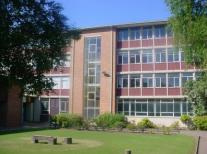
Torfaen is a county constituency represented in the House of Commons of the Parliament of the United Kingdom. It returns one Member of Parliament (MP), elected by the first past the post system.
Croesyceiliog is a suburb of Cwmbran.
Monmouth district was one of five districts of Gwent in Wales between 1974 and 1996. In 1988 the district was granted a charter conferring borough status, becoming the Borough of Monmouth.

Fairwater is a community and suburb of Cwmbran in the county borough of Torfaen, in south east Wales, and was built by the Cwmbran Development Corporation between 1963 and 1966.

The Blaenau Gwent People's Voice Group was a political party based in the Blaenau Gwent area of Wales.

Monmouthshire County Council is the governing body for the Monmouthshire principal area – one of the unitary authorities of Wales.

Gwent is a preserved county and a former local government county in south-east Wales. It was formed on 1 April 1974, under the Local Government Act 1972, and was named after the ancient Kingdom of Gwent. The authority was a successor to both the administrative county of Monmouthshire and the county borough of Newport.

The Afon Lwyd is a 13-mile long river in south-east Wales which flows from its source north of Blaenavon, through Abersychan, Pontnewynydd, Pontypool, Llanfrechfa and Cwmbran before flowing into the River Usk at Caerleon, which subsequently flows into the Bristol Channel in Newport.

Pontypool Museum – formerly the Valley Inheritance Museum – is an accredited museum located in Pontypool, Torfaen, south Wales. It is managed by the Torfaen Museum Trust. The museum is situated within the Georgian stable block that once formed part of residence of the Hanbury family – local ironmasters during the 18th and 19th centuries.
Park is an electoral ward of the Borough of Reading, in the English county of Berkshire. It is the far eastern ward and is bordered to its west by Abbey, Church and Redlands wards. On the north, east and south it is bordered by the civil parish of Earley in the Borough of Wokingham.

The 2015 United Kingdom general election in Wales was held on 7 May 2015 and all 40 seats in Wales were contested. The election for each seat was conducted on the basis of first-past-the-post.

