
Trelill (Cornish : Traughlille) [1] is a hamlet in North Cornwall, United Kingdom. Trelill Tunnel carries the disused railway line to Wadebridge and Trelill Wood is in the valley of the River Allen.
Trelill (Cornish : Traughlille) [1] is a hamlet in North Cornwall, United Kingdom. Trelill Tunnel carries the disused railway line to Wadebridge and Trelill Wood is in the valley of the River Allen.
Trelill was part of the larger St Kew parish. It was part of the estate of Plympton Priory and later the Bishop of Exeter, before the dissolution of the monasteries. For many years, the manor was held by the Molesworth family. [2]
Cornwall was an area where Methodism had a significant impact, and by the early 19th century there were 19 Methodist members in Trelill, so that a chapel to seat 130 was built in 1812. In 1854 the chapel was in use by the United Free Methodists and a small burial ground was added in 1914. The chapel closed in 1990 and has been converted into a private dwelling although the burial ground remained in use. [3] It is a Grade II listed building. [4]
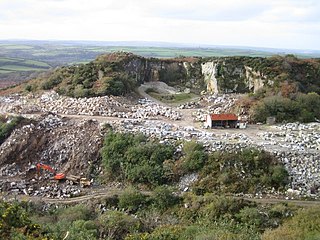
To the west of Trelill village is the abandoned Trelill Quarry. Tetrahedrite has been found here, [5] along with chert [6] and tuff. [7] Also nearby is the disused Trewethen Mine which had five shafts following a lode of lead-zinc for up to 260 fathoms (475 m). A second level of Antimony was also pursued here. [8]
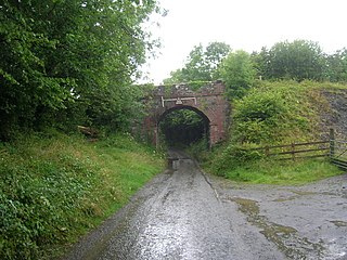
Trelill Tunnel is a railway tunnel on the now-closed North Cornwall Railway, which ran the Atlantic Coast Express to London, between Wadebridge and Camelford and passes directly under Trelill village. Construction of the tunnel, the only tunnel on the North Cornwall Railway [9] commenced in 1893 [10] and by January 1894 over 100 yards had been tunnelled into the hill. [11] The breakthrough took place around the end of June that year and by the end of August about one third of the 333 yards (304 m) length had been opened out to the full size. [11] The tunnel, which is built on a curve and a falling gradient towards St Kew Highway, is single-bore, but part of the agreement allowed the size to be increased to accommodate double-track although this was never required as traffic was always light. During the Second World War the tunnel was guarded by the Home Guard although the only event of any note was when a single German aircraft dropped some bombs which fell in a nearby field. [12] The line closed on 3 October 1966 as part of Dr Beeching's railway cuts and the track removed soon after, although the tunnel was still in existence in 2020.

The River Camel is a river in Cornwall, England. It rises on the edge of Bodmin Moor and with its tributaries its catchment area covers much of North Cornwall. The river flows into the eastern Celtic Sea between Stepper Point and Pentire Point having covered about 30 miles (50 km) making it the second longest river wholly in Cornwall. The river is tidal upstream to Egloshayle and is popular for sailing, birdwatching and fishing. The name Camel comes from the Cornish language for 'the crooked one', a reference to its winding course. Historically the river was divided into three named stretches. Heyl was the name for the estuary up to Egloshayle, the River Allen was the stretch between Egloshayle and Trecarne, whilst the Camel was reserved for the stretch of river between its source and Trecarne.
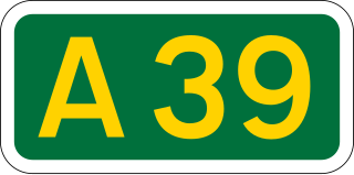
The A39 is an A road in south west England. It runs south-west from Bath in Somerset through Wells, Glastonbury, Street and Bridgwater. It then follows the north coast of Somerset, Devon and Cornwall through Williton, Minehead, Porlock, Lynmouth, Barnstaple, Bideford, Stratton, Camelford, Wadebridge and St Columb Major. It then joins the route of the A30 road for around 5 miles (8.0 km), re-emerging near Zelah to head for the south Cornish coast via Truro and Falmouth.
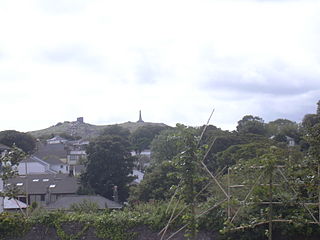
Carn Brea is a civil parish and hilltop site in Cornwall, England, United Kingdom. The population of Carn Brea including Bosleake and Church Coombe was 8,013 at the 2011 census. The hilltop site is situated approximately one mile (1.6 km) southwest of Redruth. The settlements of Bosleake, Brea, Broad Lane, Carn Arthen, Carn Brea Village, Carnkie, Four Lanes, Grillis, Illogan Highway, Pencoys, Penhallick, Piece, Pool, Tolskithy, Tregajorran, Treskillard, Tuckingmill and West Tolgus are in the parish.

The Bodmin and Wenford Railway is a 6 miles 12 chains (9.9 km) heritage railway at Bodmin in Cornwall, England. Its headquarters are at Bodmin General railway station and it connects with the national rail network at Bodmin Parkway.
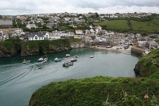
Port Isaac is a small fishing village on the Atlantic coast of north Cornwall, England, in the United Kingdom. The nearest towns are Wadebridge and Camelford, each ten miles (16 km) away. A nearby hamlet, Port Gaverne, is sometimes considered to be part of Port Isaac. The meaning of the village's Cornish name, Porthysek, is "corn port", indicating a trade in corn from the arable inland district.

Wadebridge is a town and civil parish in north Cornwall, England, United Kingdom. The town straddles the River Camel five miles upstream from Padstow. The permanent population was 6,222 in the census of 2001, increasing to 7,900 in the 2011 census. There are two electoral wards in the town. Their total population is 8,272.

The Camel Trail is a permissive cycleway in Cornwall, England, United Kingdom, that provides a recreational route for walkers, runners, cyclists and horse riders. As a rail trail, the route has only a slight incline following the River Camel from Padstow to Wenford Bridge via Wadebridge and Bodmin, at a total of 18.3 miles (29.5 km) long.
Chapel Amble is a village in the civil parish of St Kew, north Cornwall, England, United Kingdom. It is situated 2 miles (3.2 km) north of Wadebridge next to the River Amble, a tributary of the River Camel. The oldest part of the village lies on rising ground facing south-east across the river.
St Kew is a village in Cornwall, England, United Kingdom. It is also the name of the civil parish, which includes the church town, St Kew, and nearby St Kew Highway.
De Lank Quarries is an active quarry and a 54-acre geological Site of Special Scientific Interest in St Breward parish, north Cornwall, England, UK. The quarry, which received its SSSI notification in 1994, takes its name from the nearby De Lank river. The quarry produces typical biotite granites and are of such quality that a slab now forms the base section of the reception desk at the Geological Society of London. Other notable structures built of De Lank granite are the fourth Eddystone Lighthouse, 1882; the Royal Opera House in Covent Garden, London and the New Parliamentary Building in Whitehall, London
St Merryn is a civil parish and village in north Cornwall, England, United Kingdom. It is about 3.5 miles (5.6 km) south of the fishing port of Padstow and 11 miles (18 km) northeast of the coastal resort of Newquay.

The North Cornwall Railway (NCR) also known as the North Cornwall Line, was a standard gauge railway line running from Halwill in Devon, to Padstow in Cornwall, at a distance of 49 miles 67 chains via Launceston, Camelford and Wadebridge. The line was opened in late 19th century by the North Cornwall Railway Company with support throughout much of its construction and existence by the London and South Western Railway (LSWR).
The Okehampton–Bude line was a railway line built to serve Holsworthy in Devon, and Bude on the Cornish coast near the Devon border in England. The line branched from the main line at Meldon Junction to the west of Okehampton on the northern edge of Dartmoor. The line opened in 1879 to Holsworthy and in 1898 to Bude. It is now closed.
The Truro and Newquay Railway was a Great Western Railway line in Cornwall, England, designed to keep the rival London and South Western Railway (LSWR) out of the west of the county. The line was completed in 1905 and closed in 1963.

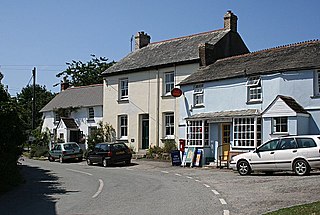
Pendoggett is a village in the civil parish of St Kew, Cornwall, England, United Kingdom. It is a linear village stradling the B3314 Wadebridge to Delabole road about five miles (8 km) northwest of Wadebridge, four miles (6.5 km) southeast of Delabole, and two miles (3 km) southeast of Port Isaac.

Wenfordbridge, or Wenford Bridge, is a hamlet some 6 miles (9.7 km) north of Bodmin and on the western flank of Bodmin Moor, in Cornwall, England. It takes its name from an old granite bridge over the River Camel, and lies on the border between the parishes of St Breward and St Tudy.

Ruthernbridge is a village in the parish of Withiel in Cornwall, England, UK.
Trequite is a hamlet in the parish of St Kew, Cornwall, England, United Kingdom. It is half a mile east of St Kew.
Mulberry Downs Quarry is a disused opencast tin mine in Cornwall, England, UK. Today the site is described as a 'chasm' being a steep or sheer-sided pit 700 foot (210 m) long and up to 100 foot (30 m) deep, and the quarry and immediate surroundings are heavily wooded. The quarry was designated as a Site of Special Scientific Interest (SSSI) in 1973 for its geological interest.
Wadebridge and Padstow Rural District was a local government division of Cornwall in England, UK, between 1968 and 1974. The rural district was created in 1968 through the abolition of Padstow Urban District and Wadebridge Rural District.
| Unitary authorities | |
|---|---|
| Major settlements (cities in italics) |
|
| Rivers | |
| Topics | |