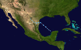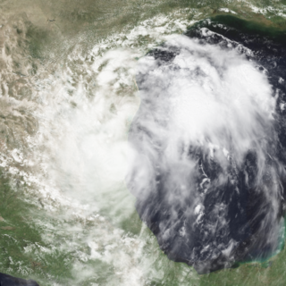
Tropical Storm Gabrielle caused moderate flooding in northeastern Mexico and southern Texas in August 1995. The eighth tropical cyclone and seventh named storm of the 1995 Atlantic hurricane season, Gabrielle developed from a tropical wave in the west-central Gulf of Mexico on August 9. Initially a tropical depression, the system gradually intensified and by the following day, it became a tropical storm. Favorable conditions caused Gabrielle to continue to strengthen, with the storm nearly reaching hurricane status late on August 11. However, it soon made landfall near La Pesca, Tamaulipas, thus halting further intensification. Once inland, Gabrielle rapidly weakened and dissipated by early on August 12.
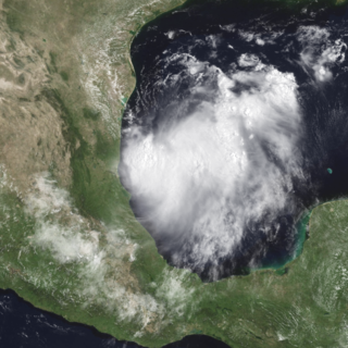
Tropical Storm Beryl made landfall just south of the Mexico–United States border in mid-August 2000, causing minimal damage. The second named storm of the 2000 Atlantic hurricane season, Beryl originated from a tropical wave near the African coastline. Tracking westward, the wave failed to organize substantially until entering the Bay of Campeche, at which time it developed into a tropical storm. Beryl rapidly deepened while in the Gulf of Mexico, and it initially was forecast to strengthen to a hurricane under favorable conditions for development. Instead, Beryl remained at moderate tropical storm intensity and failed to intensify any further. It made landfall in the Mexican state of Tamaulipas as a weak tropical storm with winds of 50 mph (80 km/h) on August 15, 2000 and dissipated over mountainous terrain shortly thereafter. One death was reported in Mexico due to drowning. Otherwise, no significant damage was reported associated with Beryl, as it affected a sparsely populated area of Mexico.

The 2011 Pacific hurricane season was a below average season in terms of named storms, although it had an above average number of hurricanes and major hurricanes. During the season, 13 tropical depressions formed along with 11 tropical storms, 10 hurricanes and 6 major hurricanes. The season officially began on May 15 in the East Pacific Ocean, and on June 1 in the Central Pacific; they both ended on November 30. These dates conventionally delimit the period of each year when most tropical cyclones form in the Pacific basin. The season's first cyclone, Hurricane Adrian formed on June 7, and the last, Hurricane Kenneth, dissipated on November 25.

The 2012 Pacific hurricane season was a moderately active Pacific hurricane season that saw an unusually high number of tropical cyclones pass west of the Baja California Peninsula. The season officially began on May 15 in the eastern Pacific Ocean, and on June 1 in the central Pacific (from 140°W to the International Date Line, north of the equator; they both ended on November 30. These dates conventionally delimit the period of each year when most tropical cyclones form in these regions of the Pacific Ocean. However, the formation of tropical cyclones is possible at any time of the year. This season's first system, Tropical Storm Aletta, formed on May 14, and the last, Tropical Storm Rosa, dissipated on November 3.

Tropical Storm Carlos was the first of five tropical cyclones to make landfall during the 2003 Pacific hurricane season. It formed on June 26 from a tropical wave to the south of Mexico. It quickly strengthened as it approached the coast, and early on June 27 Carlos moved ashore in Oaxaca with winds of 65 mph (105 km/h). The storm rapidly deteriorated to a remnant low, which persisted until dissipating on June 29. Carlos brought heavy rainfall to portions of southern Mexico, peaking at 337 mm (13.3 in) in two locations in Guerrero. Throughout its path, the storm damaged about 30,000 houses, with a monetary damage total of 86.7 million pesos. At least nine people were killed throughout the country, seven due to mudslides and two from river flooding; there was also a report of two missing fishermen.

The 2016 Pacific hurricane season was tied as the fifth-most active Pacific hurricane season on record, alongside the 2014 season. Throughout the course of the year, a total of 22 named storms, 13 hurricanes and six major hurricanes were observed within the basin. Although the season was very active, it was considerably less active than the previous season, with large gaps of inactivity at the beginning and towards the end of the season. It officially started on May 15 in the Eastern Pacific, and on June 1 in the Central Pacific ; they both ended on November 30. These dates conventionally delimit the period of each year when most tropical cyclones form in these regions of the Pacific Ocean. However, tropical development is possible at any time of the year, as demonstrated by the formation of Hurricane Pali on January 7, the earliest Central Pacific tropical cyclone on record. After Pali, however, no tropical cyclones developed in either region until a short-lived depression on June 6. Also, there were no additional named storms until July 2, when Tropical Storm Agatha formed, becoming the latest first-named Eastern Pacific tropical storm since Tropical Storm Ava in 1969, later was surpassed by Tropical Storm Aletta eight years later.

The 2017 Pacific hurricane season was an above average Pacific hurricane season in terms of named storms, though less active than the previous three, featuring eighteen named storms, nine hurricanes, and four major hurricanes. Despite the considerable amount of activity, most of the storms were weak and short-lived. The season officially started on May 15 in the eastern Pacific Ocean, and on June 1 in the central Pacific; they both ended on November 30. These dates conventionally delimit the period of each year when most tropical cyclones form in the respective regions. However, the formation of tropical cyclones is possible at any time of the year, as illustrated in 2017 by the formation of the season's first named storm, Tropical Storm Adrian, on May 9. At the time, this was the earliest formation of a tropical storm on record in the eastern Pacific basin proper. The season saw near-average activity in terms of accumulated cyclone energy (ACE), in stark contrast to the extremely active seasons in 2014, 2015, and 2016; and for the first time since 2012, no tropical cyclones formed in the Central Pacific basin. However, for the third year in a row, the season featured above-average activity in July, with the ACE value being the fifth highest for the month. Damage across the basin reached $375.28 million (2017 USD), while 45 people were killed by the various storms.

Hurricane Celia was the second-earliest forming Category 5 hurricane in the Eastern Pacific on record, after 1973's Hurricane Ava. The fourth tropical cyclone, third named storm, first hurricane, and first major hurricane of the very inactive 2010 Pacific hurricane season, Celia formed from a tropical wave about 370 mi (595 km) southeast of Acapulco, Mexico on June 18, Celia quickly organized as deep convection consolidated around the center, attaining hurricane status by June 20. Over the following days, the hurricane's winds fluctuated as wind shear impeded significant development hindering it from becoming potentially dangerous. Once this shear lightened on June 24, the storm rapidly intensified to attain its peak strength with winds of 160 mph (255 km/h) and an estimated barometric pressure of 921 mbar. Not long after reaching this strength, wind shear increased and the system entered a dry, stable environment. Over the following 42 hours, Hurricane Celia's sustained winds decreased to tropical storm force and the system began to stall over the open ocean by June 27. Despite highly unfavorable conditions, the storm managed to retain tropical storm status through June 28 and degenerated into a non-convective remnant low that evening. The remnants of Celia drifted northward, completing a counter-clockwise loop, and dissipated on June 30, 2010.

Tropical Storm Bonnie was a small and rather weak tropical storm that brought squally weather to the northern Caribbean Sea and Gulf Coast of the United States in July 2010. The third tropical cyclone and second named storm of the 2010 Atlantic hurricane season, Bonnie developed from a tropical wave over the Bahamas on July 22. It strengthened to a tropical storm while crossing the islands, and made landfall on the southeastern coast of Florida the following day. Inland, Bonnie weakened to a tropical depression before entering the Gulf of Mexico, where its surface circulation dissipated on July 24. The remnants of the storm moved ashore between Louisiana and Mississippi early on July 25, prompting severe thunderstorm and tornado warnings in the area.

Tropical Depression Five was an Atlantic tropical cyclone that lasted for 12 hours, although its remnants persisted for almost another week. Its precursor was from a non-tropical trough east of Florida, and on August 10 it developed in the southeastern Gulf of Mexico. It was the fifth depression of the 2010 Atlantic hurricane season. The system was declassified as a tropical cyclone the following day, a remnant circulation later moved over Louisiana and Mississippi, producing heavy rainfall and causing flooding. Along the Florida coast, the system produced heavy waves that contributed to two deaths. Moving inland, the remnants of the depression reached central Alabama before turning southward. The system nearly redeveloped into a tropical cyclone on August 16 after it again reached the Gulf of Mexico, but it became disorganized and turned northward into Mississippi. The depression twice caused BP to delay work in building a relief well to combat the Deepwater Horizon oil spill.

Tropical Storm Hermine was a near-hurricane strength tropical cyclone that brought widespread flooding from Guatemala northwards to Oklahoma in early September 2010. Though it was named in the western Gulf of Mexico, Hermine developed directly from the remnant low-pressure area associated with the short-lived Tropical Depression Eleven-E in the East Pacific. Throughout its lifespan, the storm caused 52 direct deaths and roughly US$740 million in damage to crops and infrastructure, primarily in Guatemala. The precursor tropical depression formed on September 3 in the Gulf of Tehuantepec and neared tropical storm intensity before making landfall near Salina Cruz, Mexico, on the next day. Though the depression quickly weakened to a remnant low, the disturbance crossed the Isthmus of Tehuantepec and tracked north into the warm waters of the Gulf of Mexico, where it reorganized into a tropical cyclone once again on September 5. There, the system quickly strengthened into a tropical storm and received the name Hermine before moving ashore near Matamoros, Mexico on September 7 as a high-end tropical storm. Over the next few days, Hermine weakened as it moved over the U.S. Southern Plains, eventually dissipating over Kansas on September 10.
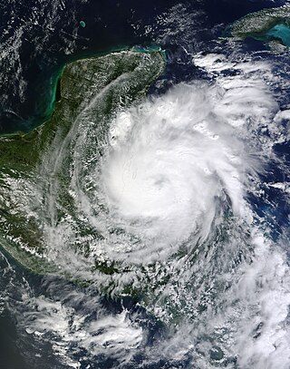
Hurricane Richard was a damaging tropical cyclone that affected areas of Central America in October 2010. It developed on October 20 from an area of low pressure that had stalled in the Caribbean Sea. The system moved to the southeast before turning to the west. The storm slowly organized, and the system intensified into a tropical storm. Initially, Richard only intensified slowly in an area of weak steering currents. However, by October 23, wind shear diminished, and the storm intensified faster as it headed toward Belize. The next day, Richard intensified into hurricane status, and further into its peak intensity as a Category 2 hurricane, reaching maximum winds of 100 mph (160 km/h). The hurricane made its only landfall on Belize at peak intensity. Over land, Richard quickly weakened, and later degenerated into a remnant low on October 25.
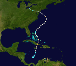
Hurricane Sandy was the sixth-costliest Atlantic hurricane on record. It lasted for over a week in late October-early November 2012. Classified as the eighteenth named storm, tenth hurricane, and second major hurricane of the annual hurricane season, Sandy originated from a tropical wave on October 22. Performing a small loop over the central Caribbean Sea, the system intensified into a tropical storm a day later and became the final hurricane of the season before briefly coming ashore the coast of Jamaica on October 24. After emerging between Jamaica and Cuba, Sandy began a period of rapid intensification into a Category 3 hurricane on the Saffir–Simpson hurricane wind scale, with maximum sustained winds of 115 mph (185 km/h). It made landfall at this intensity near Santiago de Cuba on October 25.

Tropical Storm Emily was a rapidly-forming tropical cyclone that made landfall on the west coast of Florida. The fifth named storm of the 2017 Atlantic hurricane season, Emily formed from a small area of low pressure that developed along a cold front in late July 2017. Unexpectedly, the low rapidly organized and strengthened into a tropical depression on July 30, and then into a tropical storm early the next day. Emily continued to intensify as it moved eastward, peaking with maximum sustained winds of 60 mph (95 km/h) as it made landfall near Longboat Key on the western Florida coast. The cyclone weakened quickly into a tropical depression shortly after landfall as its circulation became increasingly disrupted. Emerging into the Atlantic Ocean on August 1, Emily continued to weaken as it accelerated northeastward, becoming post-tropical early on August 2.

Hurricane Harvey was the costliest tropical cyclone on record, inflicting roughly $125 billion in damage across the Houston metropolitan area and Southeast Texas. It lasted from mid-August until early September 2017, with many records for rainfall and landfall intensity set during that time. The eighth named storm, third hurricane, and first major hurricane of the 2017 Atlantic hurricane season, Harvey originated from a broad area of low pressure southwest of Cape Verde that was first monitored on August 13. Tracking steadily westward, the disturbance developed strong convection, a well-defined circulation, and sustained tropical storm-force winds, leading to the classification of Tropical Storm Harvey late on August 17. Moderate easterly vertical wind shear kept Harvey weak, as it continued westwards into the Caribbean Sea; despite repeated predictions for gradual intensification by the National Hurricane Center, Harvey eventually opened up into a tropical wave on August 19. The remnants of Harvey continued to move westwards and reached the Yucatán Peninsula on August 22, and were forecast to regenerate into a tropical cyclone after exiting land.
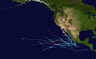
The 2021 Pacific hurricane season was a moderately active Pacific hurricane season, with above-average activity in terms of number of named storms, but below-average activity in terms of major hurricanes, as 19 named storms, 8 hurricanes, and 2 major hurricanes formed in all. It also had a near-normal accumulated cyclone energy (ACE). The season officially began on May 15, 2021 in the Eastern Pacific Ocean, and on June 1, 2021, in the Central Pacific in the Northern Hemisphere. The season ended in both regions on November 30, 2021. These dates historically describe the period each year when most tropical cyclogenesis occurs in these regions of the Pacific and are adopted by convention. However, the formation of tropical cyclones is possible at any time of the year, as illustrated by the formation of Tropical Storm Andres on May 9, which was the earliest forming tropical storm on record in the Eastern Pacific. Conversely, 2021 was the second consecutive season in which no tropical cyclones formed in the Central Pacific.

The 2022 Pacific hurricane season was an above average hurricane season in the eastern North Pacific basin, with nineteen named storms, ten hurricanes, and four major hurricanes. Two of the storms crossed into the basin from the Atlantic. In the central North Pacific basin, no tropical cyclones formed. The season officially began on May 15 in the eastern Pacific, and on June 1 in the central; both ended on November 30. These dates historically describe the period each year when most tropical cyclogenesis occurs in these regions of the Pacific and are adopted by convention.
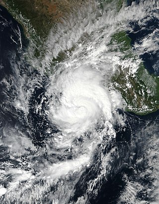
Hurricane Rick was a Category 2 Pacific hurricane that struck the southwestern coast of Mexico in late October 2021. Rick was the overall seventeenth named system and the eighth hurricane of the 2021 Pacific hurricane season, as well as the fifth named storm and fourth hurricane to make landfall along the Pacific coast of Mexico in 2021.
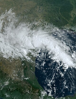
Tropical Storm Harold was a moderate tropical storm that made landfall in South Texas in August 2023. The eighth named storm of the 2023 Atlantic hurricane season, Harold developed from a tropical wave that entered the Gulf of Mexico on August 20, after passing through the Bahamas and Straits of Florida. The system steadily organized over the following days, over record-warm sea-surface temperatures in the Gulf, as it progressed westward. Although the disturbance had not become organized enough to become a tropical cyclone yet, due to the threat it posed to southern Texas, the United States–based National Hurricane Center (NHC) initiated advisories on the system as Potential Tropical Cyclone Nine on August 21. The disturbance organized into a tropical depression six hours later, before strengthening into a tropical storm the following morning and receiving the name Harold. Harold continued to strengthen as it moved quickly westward, and the cyclone made landfall on Padre Island, Texas, around 15:00 UTC on August 22, as a 60 mph (95 km/h) tropical storm. Harold quickly weakened as it moved inland over southern Texas and dissipated on August 23, though its remnant mid-level circulation and associated moisture affected the central United States for several more days.

