
Namushka Lodge Water Aerodrome, is located on the northeast side of Harding Lake in the Northwest Territories, Canada and is open from the middle of June until October.
Great Bear Lake Water Aerodrome, is located 1 nautical mile south of the lodge on the Dease Arm of Great Bear Lake, Northwest Territories, Canada and is open from the middle of July until September.
Obre Lake/North of Sixty Water Aerodrome on Obre Lake, Northwest Territories, Canada is adjacent to the lodge. The aerodrome is open from the middle of June until October.

Braeburn Airport, also known as the Cinnamon Bun Airstrip, in the Yukon, Canada, is adjacent to the Klondike Highway between Whitehorse and Carmacks. It is next to Braeburn Lodge and near Braeburn Lake. It receives no maintenance and pilots are advised to use caution as there are numerous holes in the runway caused by gophers.

Little Churchill River/Dunlop's Fly In Lodge Aerodrome,, is located in Northern Manitoba, Canada. It is on Waskaiowaka Lake, the source of the Little Churchill River, at the point where the river leaves the lake.
Molson Lake Airport,, is located 2 nautical miles northwest of Molson Lake, Manitoba, Canada. The airstrip services Molson Lake Lodge and is maintained by the workers at the lodge.
Nejanilini Lake Airport,, is located adjacent to Nejanilini Lake, Manitoba, Canada and serves "The Lodge at Little Duck".
North Seal River Airport,, is located on the shore of Egenolf Lake adjacent to North Seal River, Manitoba, Canada.
Pine Dock Water Aerodrome,, is located in Big Bullhead Bay on Lake Winnipeg, 1 nautical mile south of Pine Dock, on Lake Winnipeg, Manitoba, Canada.

Chilko Lake Aerodrome,, is located near to Chilko Lake, British Columbia, Canada.

Black Lake Water Aerodrome,, is located 2 nautical miles east northeast of the community of Black Lake, Saskatchewan, Canada and on Black Lake.
Cree Lake/Crystal Lodge Aerodrome,, is located adjacent to Crystal Lodge, a fly-in fishing lodge on Cree Lake, Saskatchewan, Canada. The airport is located on Ispatinow Island, the largest island in the lake.
Davin Lake Airport, formerly TC LID: CKW6, was located adjacent to Davin Lake Lodge, a fly-in fishing lodge in northern Saskatchewan, Canada.
Moose Lake (Lodge) Airport is located adjacent to Moose Lake, British Columbia, Canada.
Moose Lake (Lodge) Water Aerodrome,, is located on Moose Lake, British Columbia, Canada.
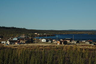
Colville Lake is a settlement corporation located in the Sahtu Region of the Northwest Territories, Canada. The community is located 50 km (31 mi) north of the Arctic Circle, on a lake of the same name, and is northeast of Norman Wells. This settlement is the administrative office of the Behdzi Ahda band government.

Sambaa K'e is a "Designated Authority" in the Dehcho Region of the Northwest Territories, Canada. The community is located near the Alberta border, east of Fort Liard, on the shore of the lake also known as Sambaa K'e. It has no all-weather road, but can be reached by winter road early in the year or by air year-round.

Wekweètì, officially the Tłı̨chǫ Community Government of Wekweètì is a community in the North Slave Region of the Northwest Territories, Canada. Wekweètì is a Tłı̨chǫ aboriginal community and is located 195 km (121 mi) north of Yellowknife. It has no year-round road access but does have a winter ice road connection; the majority of transportation to and from the community is through the Wekweètì Airport. Wekweètì is the closest community to the Ekati Diamond Mine on the border with Nunavut. Wekweètì is part of the Tlicho Government.
Cree Lake Water Aerodrome,, is located adjacent to Crystal Lodge, a fly-in fishing lodge on Cree Lake, Saskatchewan, Canada. The airport is located alongside Cree Lake/Crystal Lodge Aerodrome on Ispatinow Island, the largest island in the lake.
Graham Lake Water Aerodrome, is located on Graham Lake, near the Yellow Dog Lodge, approximately 55 km (34 mi) north northeast of Yellowknife, Northwest Territories, Canada.
