Budapest is the capital and most populous city of Hungary. It is the ninth-largest city in the European Union by population within city limits and the second largest city on the Danube river. The city has an estimated population of 1,752,286 over a land area of about 525 square kilometres. Budapest, which is both a city and municipality, forms the centre of the Budapest metropolitan area, which has an area of 7,626 square kilometres and a population of 3,303,786. It is a primate city, constituting 33% of the population of Hungary.

Buda is the part of Budapest, the capital city of Hungary, that lies on the western bank of the Danube. Historically, “Buda” referred only to the royal walled city on Castle Hill, which was constructed by Béla IV between 1247 and 1249 and subsequently served as the capital of the Kingdom of Hungary from 1361 to 1873. In 1873, Buda was administratively unified with Pest and Óbuda to form modern Budapest.

Miskolc is a city in northeastern Hungary, known for its heavy industry. With a population of 161,265 as of 1 January 2014, Miskolc is the fourth largest city in Hungary. It is also the county capital of Borsod-Abaúj-Zemplén and the regional centre of Northern Hungary.

Zalaegerszeg is the administrative center of Zala county in western Hungary.

Ferenc Kazinczy,, was a Hungarian author, poet, translator, neologist, an agent in the regeneration of the Hungarian language and literature at the turn of the 19th century. Today his name is connected with the extensive Language Reform of the 19th century, when thousands of words were coined or revived, enabling the Hungarian language to keep up with scientific progress and become an official language of the nation in 1844. For his linguistic and literary works he is regarded as one of the cultural founders of the Hungarian Reform Era along with Dávid Baróti Szabó, Ferenc Verseghy, György Bessenyei, Mátyás Rát and János Kis.

Count Lajos Batthyány de Németújvár was the first Prime Minister of Hungary. He was born in Pozsony on 10 February 1807, and was executed by firing squad in Pest on 6 October 1849, the same day as the 13 Martyrs of Arad.
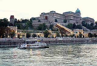
Castle Hill is a hill in Budapest's 1st district. Geographically, it is connected to the Buda Hills and Rose Hill (Rózsadomb). The Castle Quarter (Várnegyed) is located on the top of the hill with many monuments around the Buda Castle. The area is one of the most popular attractions in the capital, and can be accessed by bus or in the carriages of a funicular.

Hatvan is a town in Heves county, Hungary. Hatvan is the Hungarian word for "sixty". It is the county's third most populous town following Eger and Gyöngyös.
The architecture of Hungary is understood as the architecture of the territory of the country of Hungary, and in a wider, of the Kingdom of Hungary, from the conquest to the present day.
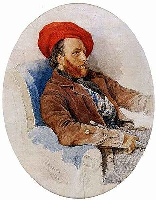
Frigyes Feszl was an architect and a significant figure in the Hungarian romantic movement.
Acsa is a village in Pest County, Hungary.
Vácszentlászló is a village and commune in the comitatus of Pest in Hungary.
Boldog is a municipality in the Hatvan kistérség of Heves County, Northern Hungary Region. It is situated between the rivers Zagyva and Galga and is located 9 km from Hatvan.

The Battle of Isaszeg took place in the Spring Campaign of the Hungarian War of Independence from 1848 to 1849, between the Austrian Empire and the Hungarian Revolutionary Army supplemented by Polish volunteers. The Austrian forces were led by Field Marshal Alfred I, Prince of Windisch-Grätz and the Hungarians by General Artúr Görgei. The battle was one of the turning points of the Hungarian War of Independence, being the decisive engagement of the so-called Gödöllő operation, and closing the first phase of the Spring Campaign.
The following is a timeline of the history of the city of Budapest, Hungary.

The Battle of Hatvan was the first battle in the Spring Campaign of the Hungarian War of Independence of 1848–1849, fought on 2 April 1849 between the Habsburg Empire and the Hungarian Revolutionary Army. This battle was the start of the Hungarian offensive whose aim was to liberate central and western Hungary, and its capital, from imperial occupation. The Austrian force was commanded by General Franz Schlik, while the Hungarians were led by Colonel András Gáspár, and lieutenant-colonel Ernő Poeltenberg. The Polish Legion under Colonel Józef Wysocki also fought alongside the Hungarians. The Hungarians were victorious, and advanced towards the Hungarian capitals, Buda and Pest.
Aszód is a district in north-eastern part of Pest County. Aszód is also the name of the town where the district seat is found. The district is located in the Central Hungary Statistical Region.

The Battle of Vác, fought between 15 and 17 July 1849, was one of two important battles which took place in Vác during the Hungarian War of Independence. This battle, fought between the Russian Empire's intervention forces led by Field Marshal Ivan Paskevichand and the Hungarian Army of the Upper Danube led by General Artúr Görgei, was part of the Summer Campaign. After the lost battle of Komárom from 11 July 1849, Görgei tried to lead his army to the planned concentration point of the Hungarian troops around Szeged, but the Russians cut his road at Vác. In the battle, the still convalescent Görgei managed to capture Vác from the Russians, repulse the Russian attacks, then to retreat towards North-East, as much superior Russian forces arrived. Fearing that Görgei will cut their supply lines, after the battle, the four times bigger Russian army, instead of marching towards Szeged in order to unite with the Austrian main army of Field Marshal Julius Jacob von Haynau, and to crush the much weaker Hungarian forces which were gathering there, followed Görgei's retreating troops, enabling them to arrive to the Hungarian concentration point with several days in front of them, creating the condition to unite with the Southern Hungarian troops, and crush the Austrian army of Haynau before the Russians arrived. Considering the fact that the actual plan of Görgei was to arrive to the concentration point before the Russians, and, as a result of the battle of Vác from 15 to 17 July, he managed to achieve this, this battle is considered a strategic victory for the Hungarians.
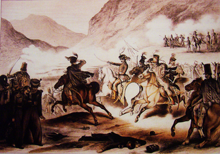
The Battle of Tura was fought around the village of Tura by the cavalry of the IX. and the X. corps of the Hungarian revolutionary army led by General Mór Perczel and the Russian cavalry detachment led by Lieutenant General Aleksandr Petrovich Tolstoy and the 1. brigade of the 5. infantry division led by Lieutenant General Ivan Mikhaylovich Labintsov. The Hungarians advanced towards North in order to relieve the Russian pressure over General Artúr Görgei's Army of the Upper Danube, which after the second battle of Vác from 15 to 17 July was heading towards the Hungarian armies meeting point around Szeged. The battle started between the Hungarian cavalry units under Perczel and the Russian cavalry under Tolstoy. The Hungarians pushed back the Russian cavalry, but when the Russian infantry led by Labintsov arrived, Perczel retreated. The Russians did not pursued his troops. Although the Russians remained the masters of the battlefield, Perczel's objective to ease the Russian pressure over Görgei's troops succeeded, helping in this way the latter to succeed in his march to Southern Hungary.


