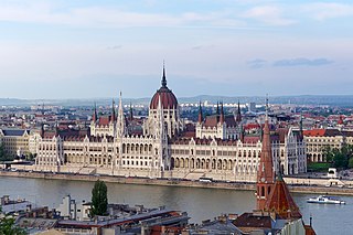
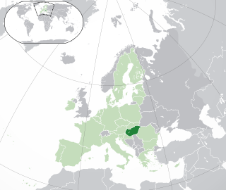
Budapest is the capital and most populous city of Hungary. It is the ninth-largest city in the European Union by population within city limits and the second largest city on the Danube river. The city has an estimated population of 1,752,286 over a land area of about 525 square kilometres. Budapest, which is both a city and municipality, forms the centre of the Budapest metropolitan area, which has an area of 7,626 square kilometres and a population of 3,303,786. It is a primate city, constituting 33% of the population of Hungary.

Buda is the part of Budapest, the capital city of Hungary, that lies on the western bank of the Danube. Historically, “Buda” referred only to the royal walled city on Castle Hill, which was constructed by Béla IV between 1247 and 1249 and subsequently served as the capital of the Kingdom of Hungary from 1361 to 1873. In 1873, Buda was administratively unified with Pest and Óbuda to form modern Budapest.

Debrecen is Hungary's second-largest city, after Budapest, the regional centre of the Northern Great Plain region and the seat of Hajdú-Bihar County. A city with county rights, it was the largest Hungarian city in the 18th century and it is one of the Hungarian people's most important cultural centres. Debrecen was also the capital city of Hungary during the revolution in 1848–1849. During the revolution, the dethronement of the Habsburg dynasty was declared in the Reformed Great Church. The city also served as the capital of Hungary by the end of World War II in 1944–1945. It is home to the University of Debrecen.

Kaposvár is a city with county rights in southwestern Hungary, south of Lake Balaton. It is one of the leading cities of Transdanubia, the capital of Somogy County, and the seat of the Kaposvár District and the Roman Catholic Diocese of Kaposvár.

Székesfehérvár, known colloquially as Fehérvár, is a city in central Hungary, and the country's ninth-largest city. It is the regional capital of Central Transdanubia, and the centre of Fejér County and Székesfehérvár District. The area is an important rail and road junction between Lake Balaton and Lake Velence.

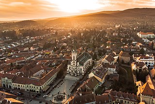
Esztergom is a city with county rights in northern Hungary, 46 kilometres northwest of the capital Budapest. It lies in Komárom-Esztergom County, on the right bank of the river Danube, which forms the border with Slovakia there. Esztergom was the capital of Hungary from the 10th until the mid-13th century when King Béla IV of Hungary moved the royal seat to Buda.

Csepel, officially known as the 21st District of Budapest is a district and a neighbourhood in Budapest, Hungary. Csepel officially became part of Budapest on 1 January 1950.
The history of the Jews in Hungary dates back to at least the Kingdom of Hungary, with some records even predating the Hungarian conquest of the Carpathian Basin in 895 CE by over 600 years. Written sources prove that Jewish communities lived in the medieval Kingdom of Hungary and it is even assumed that several sections of the heterogeneous Hungarian tribes practiced Judaism. Jewish officials served the king during the early 13th century reign of Andrew II. From the second part of the 13th century, the general religious tolerance decreased and Hungary's policies became similar to the treatment of the Jewish population in Western Europe.
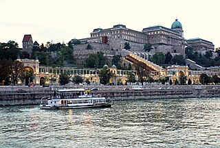
Castle Hill is a hill in Budapest's 1st district. Geographically, it is connected to the Buda Hills and Rose Hill (Rózsadomb). The Castle Quarter (Várnegyed) is located on the top of the hill with many monuments around the Buda Castle. The area is one of the most popular attractions in the capital, and can be accessed by bus or in the carriages of a funicular.
Kőszeg is a town in Vas County, Hungary. The town is known for its historical character.

Hatvan is a town in Heves county, Hungary. Hatvan is the Hungarian word for "sixty". It is the county's third most populous town following Eger and Gyöngyös.

German Hungarians are the ethnic German minority of Hungary, sometimes also called Danube Swabians, many of whom call themselves "Shwoveh" in their own Swabian dialect. There are 131,951 German speakers in Hungary. Danube Swabian is a collective term for a number of German ethnic groups who lived in the former Kingdom of Hungary, including the Kingdom of Croatia-Slavonia and Vojvodina. Other ethnic German groups previously lived on the territory of both the former Hungarian kingdom as well as on the territory of present-day Hungary since the Middle Ages onwards, most notably in Budapest but not only.
Solymár is an urban village in northwest of Budapest metropolitan area, bordering the 3rd and 2nd districts of the city, as well as Nagykovácsi, Pilisszentiván, Pilisvörösvár, Csobánka, Pilisborosjenő, and Üröm. Its picturesque surroundings and good accessibility the 64, 64A, 164, 264, 157 and 964 city buses from Hűvösvölgy, 218 from Óbuda, a train from Budapest Nyugati, and coaches from Árpád-híd) made it a desirable destination for affluent city-dwellers moving to suburban homes outside of Budapest from the mid-1990s.

Nagykovácsi is small town located in Budakeszi District, in the western part of Pest county, central Hungary. It is situated some 15 km (9 mi) north-west of the centre of Budapest, in a valley. According to the 2011 census, the population amounted to 7095, though this figure does not include individuals who own property as a secondary residence in the town. Nagykovácsi today attracts tourists and new residents alike, due to its proximity to the capital city, attractive and peaceful setting, surrounding by hills and forests. Some of the nearby areas have been designated conservation areas—Budai Tájvédelmi Körzet —in order to protect several of its rare species of flora. Its location has contributed to the town's development in recent decade. The American International School of Budapest chose Nagykovácsi as the site for its new campus in 2000.

Bátaszék is a town in Tolna County, Hungary. The majority residents are Hungarians, with a significant minority of Germans.

Budaörs is a town in Pest County, Budapest metropolitan area, Hungary.

The city of Budapest was officially created on 17 November 1873 from a merger of the three neighboring cities of Pest, Buda and Óbuda. Smaller towns on the outskirts of the original city were amalgamated into Greater Budapest in 1950. The origins of Budapest can be traced to Celts who occupied the plains of Hungary in the 4th century BC. The area was later conquered by the Roman Empire, which established the fortress and town of Aquincum on the site of today's Budapest around AD 100. The Romans were expelled in the 5th century by the Huns, who were challenged by various tribes during the next several centuries. The Hungarian conquest of the Carpathian Basin started at the end of the 9th century, and the Kingdom of Hungary was established at the end of the 11th century.

Páty is a village in Pest county, Budapest metropolitan area, Hungary. It has a population of 7,476 (2018). The neighbouring villages are: Zsámbék, Tök, Budajenő, Telki, Nagykovácsi, Budakeszi, Biatorbágy and Herceghalom. The Zsambeki basin are bound by Mézes (Honey) valley which is called as the Gate of Páty also. The Paty-basin is 180 m over the sea level in general, but its outskirts reach 210–360 m high.

Újbuda is the 11th district of Budapest, Hungary. It is the most populous district of Budapest with 137,426 inhabitants (2008). Until the 1890s, Újbuda's present territory was a field south of the historical town of Buda. The construction of a new residential area started in the 1900s, the present district was formed in 1930. From 1880 to 1980, Újbuda's population increased from 1,180 to 178,960. There are boulevards, avenues with tram lines, and communist-era housing estates in the district. Line 4 of the Budapest metro passes through Újbuda.

The Monastery of St Lawrence at Buda, also known as the Pauline Monastery of Budaszentlőrinc, is a former monastery belonging to the Pauline Order. Destroyed by the Ottomans, the remains of the monastery grounds are in an area called Szépjuhászné which is in the saddle between Hárshegy and János Hill in the 2nd district of Budapest. It is where the Pauline Order founded their first friary. Today, only the foundation walls of the monastery remain.