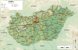
Hungary is a landlocked country in East-Central Europe with a land area of 93,030 square km. It measures about 250 km from north to south and 524 km from east to west. It has 2,106 km of boundaries, shared with Austria to the west, Serbia, Croatia and Slovenia to the south and southwest, Romania to the southeast, Ukraine to the northeast, and Slovakia to the north.

The Tisza, Tysa or Tisa, is one of the major rivers of Central and Eastern Europe. Once, it was called "the most Hungarian river" because it flowed entirely within the Kingdom of Hungary. Today, it crosses several national borders.

Komárno, colloquially also called Révkomárom, Öregkomárom, Észak-Komárom in Hungarian; is a town in Slovakia at the confluence of the Danube and the Váh rivers. Historically it was formed by the "old town" on the left bank of Danube, present day Komárno in Slovakia, and by a "new town" on the right bank, present day Komárom in Hungary, which were historically one administrative unit. Following World War I and the Treaty of Trianon, the border of the newly created Czechoslovakia cut the historical, unified town in half, creating two new independent towns in two countries. Komárno and Komárom are connected by the Elisabeth Bridge, which used to be an official border crossing between Slovakia and Hungary until border checks were lifted due to the Schengen Area rules. In 2020, a new road bridge was opened.

Szolnok is the county seat of Jász-Nagykun-Szolnok county in central Hungary. A city with county rights, it is located on the banks of the Tisza river, in the heart of the Great Hungarian Plain, which has made it an important cultural and economic crossroads for centuries. Szolnok also has one of Hungary’s best waterpolo teams.

Mosonmagyaróvár is a town in Győr-Moson-Sopron County in northwestern Hungary. It lies close to both the Austrian and Slovakian borders and has a population of 32,752.

The Danube Swabians is a collective term for the ethnic German-speaking population who lived in various countries of central-eastern Europe, especially in the Danube River valley, first in the 12th century, and in greater numbers in the 17th and 18th centuries. Most were descended from earlier 18th-century Swabian settlers from Upper Swabia, the Swabian Jura, northern Lake Constance, the upper Danube, the Swabian-Franconian Forest, the Southern Black Forest and the Principality of Fürstenberg, followed by Hessians, Bavarians, Franconians and Lorrainers recruited by Austria to repopulate the area and restore agriculture after the expulsion of the Ottoman Empire. They were able to keep their language and religion and initially developed strongly German communities in the region with German folklore. Thousands also came from Eastern Europe.

Transdanubia is a traditional region of Hungary. It is also referred to as Hungarian Pannonia, or Pannonian Hungary.

Kossuth Lajos Square, also known as Kossuth Square, is a city square situated in the Lipótváros neighbourhood of Budapest, Hungary, on the bank of the Danube. Its most notable landmark is the Hungarian Parliament Building. There is a station of the M2 (East-West) line of the Budapest Metro on the square as well as a stop for the scenic Tram No. 2.
Budakeszi is a town in Pest County, in the Budapest metropolitan area, Hungary. It is located beyond the János Hill at the western city limits of Budapest, about 12 km (7 mi) west of the Zero Kilometre Stone in the city centre. A popular recreational area, the landscape is characterized by forests, predominantly oaks, by vineyards and by orchards.

Kolárovo is a town in the south of Slovakia near the town of Komárno. It is an agricultural center with 11,000 inhabitants.

Kiskőrös is a town in Bács-Kiskun, Hungary. Kiskőrös is situated between the Danube and Tisza rivers at around 46°37′14″N19°17′19″E. Sándor Petőfi, the national poet of Hungary, was born here.
Solymár is an urban village in northwest of Budapest metropolitan area, bordering the 3rd and 2nd districts of the city, as well as Nagykovácsi, Pilisszentiván, Pilisvörösvár, Csobánka, Pilisborosjenő, and Üröm. Its picturesque surroundings and good accessibility the 64, 64A, 164, 264, 157 and 964 city buses from Hűvösvölgy, 218 from Óbuda, a train from Budapest Nyugati, and coaches from Árpád-híd) made it a desirable destination for affluent city-dwellers moving to suburban homes outside of Budapest from the mid-1990s.

Diósd is a small town located between the larger cities of Budapest and Érd in the Budapest metropolitan area, Pest County, Hungary.

Kravany nad Dunajom is a village and municipality in the Komárno District in the Nitra Region of south-west Slovakia.
Iža is a village in south-western Slovakia.

Abony is a town in Pest County, Hungary.

Törökbálint[ˈtørøɡbaːlint] is a town in Pest county, Hungary. Törökbálint received town status on 1 July 2007.

Hungarian art stems from the period of the conquest of the Carpathian basin by the people of Árpád in the 9th century. Prince Árpád also organized earlier people settled in the area.

The Devil's Dykes, also known as the Csörsz árka or the Limes Sarmatiae, are several lines of Roman fortifications built mostly during the reign of Constantine the Great (306–337), stretching between today's Hungary, Romania and Serbia.
Partiscum was a fort in the Roman province of Dacia along the limes of Marisus river. It is the most Western fort of Dacia. Its ruins are located nearby Szeged, Csongrád-Csanád County, Hungary. Latest research showed that the most likely place was in Szeged, near the Tisza river, at the old Castle of Szeged.