Gödöllő is a city in Pest County, Budapest metropolitan area, Hungary, about 30 km (20 mi) northeast from the outskirts of Budapest. Its population is 34,396 according to the 2010 census and is growing rapidly. It can be easily reached from Budapest with the suburban railway (HÉV), and national railway (MÁV-START).

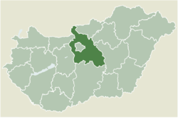
Pest is a county (vármegye) in central Hungary. It covers an area of 6,393.14 square kilometres (2,468.41 sq mi), and has a population of 1,339,090 (2023). It surrounds the national capital Budapest and the majority of the county's population live in the suburbs of Budapest. It shares borders with Slovakia and the Hungarian counties Nógrád, Heves, Jász-Nagykun-Szolnok, Bács-Kiskun, Fejér, and Komárom-Esztergom. The River Danube flows through the county. The capital of Pest County is Budapest, although Budapest is not part of Pest County. Starting 2018, they also constitute different NUTS:HU level 2 regions, as previously Pest County has lost catch-up aids from the European Union because of the high development of Budapest.

Miskolc is a city in northeastern Hungary, known for its heavy industry. With a population of 161,265 as of 1 January 2014, Miskolc is the fourth largest city in Hungary. It is also the county capital of Borsod-Abaúj-Zemplén and the regional centre of Northern Hungary.

Sárospatak is a town in Borsod-Abaúj-Zemplén County, northern Hungary. It lies 70 kilometres northeast from Miskolc, in the Bodrog river valley. The town, often called simply Patak, is a cultural centre, a historical town and a popular tourist destination.

Temerin is a town and municipality located in the South Bačka District of the autonomous province of Vojvodina in Serbia. The town has a population of 19,613, while the municipality has a population of 28,287.

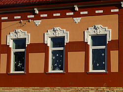
Dabas is a town in Pest County, Hungary, and the center of a microregion. It has a population of 17,000.

Cegléd is a city in Pest county, Hungary, approximately 70 km (43 mi) southeast of the Hungarian capital, Budapest.

Brockton Village is a former town, and now the name of a neighbourhood, in Toronto, Ontario, Canada. It comprises a section of the old Town of Brockton which was annexed by the City of Toronto in 1884.

Nagykovácsi is small town located in Budakeszi District, in the western part of Pest county, central Hungary. It is situated some 15 km (9 mi) north-west of the centre of Budapest, in a valley. According to the 2011 census, the population amounted to 7095, though this figure does not include individuals who own property as a secondary residence in the town. Nagykovácsi today attracts tourists and new residents alike, due to its proximity to the capital city, attractive and peaceful setting, surrounding by hills and forests. Some of the nearby areas have been designated conservation areas—Budai Tájvédelmi Körzet —in order to protect several of its rare species of flora. Its location has contributed to the town's development in recent decade. The American International School of Budapest chose Nagykovácsi as the site for its new campus in 2000.
Ádánd is a Hungarian village of 2,416 inhabitants located in Somogy, Hungary, in the south side of lake Balaton.

Gyömrő is a town in Pest county, Budapest metropolitan area, Hungary. The City of Gyömrő is situated in the center of the hilly region of Monor, in the outskirt of the capital city, Budapest. The whole territory of Gyömrő is 26,51 km2, its internal area is 6.45 km2. The number of inhabitants is about 15,290.

Sávoly is a village in Somogy county, Hungary.

Szécsény is a town in Nógrád county, Hungary.

Mogyoród is a small traditional village in Pest County, Hungary. The Battle of Mogyoród took place here on 14 March 1074, between Solomon, King of Hungary and his cousins Géza and Ladislaus, who were claiming rights to the throne. To commemorate the victory, László Benchmarks were installed, establishing a monastery on Klastrom mountain. Among the sights of the village is the Roman Catholic church, built between 1745 and 1749, the statue of St John of Nepomuk, carved from stone, and the Baroque parish built by the Bishop of Vác. The Hungaroring race track is located in the town, home to the Hungarian Grand Prix.

The city of Budapest was officially created on 17 November 1873 from a merger of the three neighboring cities of Pest, Buda and Óbuda. Smaller towns on the outskirts of the original city were amalgamated into Greater Budapest in 1950. The origins of Budapest can be traced to Celts who occupied the plains of Hungary in the 4th century BC. The area was later conquered by the Roman Empire, which established the fortress and town of Aquincum on the site of today's Budapest around AD 100. The Romans were expelled in the 5th century by the Huns, who were challenged by various tribes during the next several centuries. The Hungarian conquest of the Carpathian Basin started at the end of the 9th century, and the Kingdom of Hungary was established at the end of the 11th century.

Vácrátót is a village and commune in the comitatus of Pest in Hungary.

The Middle Ages in the Banat started around 900. Around that time, Duke Glad ruled Banat, according to the Gesta Hungarorum. Archaeological finds and 10th-century sources evidence that Magyars settled in the lowlands in the early 10th century, but the survival of Avar, Slav and Bulgar communities can also be documented. A local chieftain, Ajtony, converted to Eastern Orthodoxy around 1000, but his attempts to control the delivery of salt on the Mureș River brought him into conflict with Stephen I of Hungary. Ajtony died fighting against the royal army in the first decades of the 11th century. His realm was transformed into a county of the Kingdom of Hungary. Counties were the most prominent units of royal administration.

District XVII of Budapest is a suburban district of Budapest on the left bank of the Danube, in the eastern part of the capital. It is Budapest's largest district, with an area of 54.82 km2, and home to nearly 90,000 people, making it the seventh most populous district of Budapest. Towns that were different in nature, but closely connected, were annexed to the capital in 1950 as part of the Greater Budapest plan. It is one of the most beautifully located districts of Pest, which is partly located as high as the 235 meters Gellért Hill. As the district is part of the Pest Plain, which gradually rises from the Danube to the east, the district's area is almost entirely hilly. The 241 meter high Erdő Hill, the highest point of the Pest side and the Pest Plain is also located here.
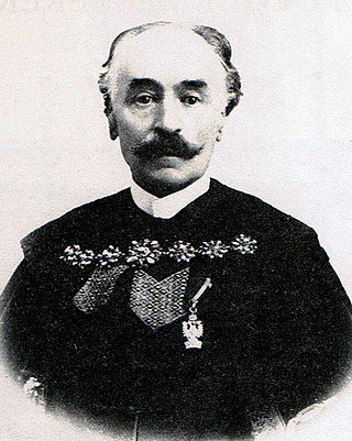
Károly Kamermayer was a Hungarian jurist and councillor, who served as the first mayor of Budapest between 1873 and 1896. During his tenure, the city grew into the country's administrative, political, economic, trade, and cultural hub, and Budapest had become one of the cultural centers of Europe.

Dabas is a district in southern part of Pest County. Dabas is also the name of the town where the district seat is found. The district is located in the Central Hungary Statistical Region.