Tuscaloosa Regional Airport

Last updated
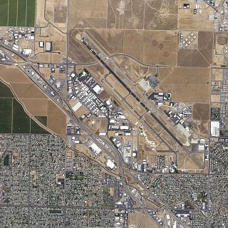
Tuscaloosa Regional Airport
Van De Graaff Field
Tuscaloosa Regional Airport.jpg
NAIP image 2006
Summary
Airport typePublic
OwnerCity of Tuscaloosa
OperatorCity of Tuscaloosa Department of Transportation, Airport Management Division
Serves Tuscaloosa, Alabama
Location Tuscaloosa County, Alabama, U.S.
Elevation  AMSL 170 ft / 52 m
Coordinates 33°13′14″N087°36′41″W / 33.22056°N 87.61139°W / 33.22056; -87.61139
Map
USA Alabama location map.svg
Airplane silhouette.svg
KTCL
Runways
Direction LengthSurface
ftm
4/226,4991,981Asphalt
12/304,0011,220Asphalt
Statistics (2016)
Aircraft operations53,371
Based aircraft93

Tuscaloosa Regional Airport( IATA : TCL, ICAO : KTCL, FAA LID : TCL) is 3.5 miles northwest of Tuscaloosa, in Tuscaloosa County, Alabama. [1] The airport is owned and operated by the City of Tuscaloosa. The FAA's National Plan of Integrated Airport Systems for 2011–2015 categorized the airport as a general aviation facility. [2]

An IATA airport code, also known as an IATA location identifier, IATA station code or simply a location identifier, is a three-letter code designating many airports around the world, defined by the International Air Transport Association (IATA). The characters prominently displayed on baggage tags attached at airport check-in desks are an example of a way these codes are used.

ICAO airport code four-letter code designating many airports around the world

The ICAOairport code or location indicator is a four-letter code designating aerodromes around the world. These codes, as defined by the International Civil Aviation Organization and published in ICAO Document 7910: Location Indicators, are used by air traffic control and airline operations such as flight planning.

Federal Aviation Administration United States Government agency dedicated to civil aviation matters

The Federal Aviation Administration (FAA) is a governmental body of the United States with powers to regulate all aspects of civil aviation in that nation as well as over its surrounding international waters. Its powers include the construction and operation of airports, air traffic management, the certification of personnel and aircraft, and the protection of U.S. assets during the launch or re-entry of commercial space vehicles. Powers over neighboring international waters were delegated to the FAA by authority of the International Civil Aviation Organization.

Contents

Tuscaloosa Regional Airport had 2,400 commercial passenger boardings (enplanements) in calendar year 2011. [3] Most of this traffic was athletic charters from the University of Alabama. The Tuscaloosa Industrial Park is next to the airport.

Generally speaking, a calendar year begins on the New Year's Day of the given calendar system and ends on the day before the following New Year's Day, and thus consists of a whole number of days. A year can also be measured by starting on any other named day of the calendar, and ending on the day before this named day in the following year. This may be termed a "year's time", but not a "calendar year". To reconcile the calendar year with the astronomical cycle certain years contain extra days.

University of Alabama public university located in Tuscaloosa, Alabama, United States

The University of Alabama is a public research university in Tuscaloosa, Alabama. It is the flagship of the University of Alabama System. Established in 1820, the University of Alabama (UA) is the oldest and largest of the public universities in Alabama. The university offers programs of study in 13 academic divisions leading to bachelor's, master's, Education Specialist, and doctoral degrees. The only publicly supported law school in the state is at UA. Other academic programs unavailable elsewhere in Alabama include doctoral programs in anthropology, communication and information sciences, metallurgical engineering, music, Romance languages, and social work.

Facilities

Tuscaloosa Regional Airport covers 724 acre s (293  ha ) at an elevation of 170 feet (52 m). It has two asphalt runways: 4/22 is 6,499 by 150 feet (1,981 x 46 m) and 11/29 is 4,001 by 100 feet (1,220 x 30 m). [1] Runway 4 has an Instrument Landing System and approach lights, allowing landings in visibility as low as a half mile.

Acre unit of area

The acre is a unit of land area used in the imperial and US customary systems. It is traditionally defined as the area of one chain by one furlong, which is exactly equal to 10 square chains, ​1640 of a square mile, or 43,560 square feet, and approximately 4,047 m2, or about 40% of a hectare. Based upon the International yard and pound agreement of 1959, an acre may be declared as exactly 4,046.8564224 square metres. The acre is a statute measure in the United States and was formerly one in the United Kingdom and almost all countries of the former British Empire, although informal use continues.

Hectare metric unit of area

The hectare is an SI accepted metric system unit of area equal to a square with 100-metre sides, or 10,000 m2, and is primarily used in the measurement of land. There are 100 hectares in one square kilometre. An acre is about 0.405 hectare and one hectare contains about 2.47 acres.

Elevation Height of a geographic location above a fixed reference point

The elevation of a geographic location is its height above or below a fixed reference point, most commonly a reference geoid, a mathematical model of the Earth's sea level as an equipotential gravitational surface . The term elevation is mainly used when referring to points on the Earth's surface, while altitude or geopotential height is used for points above the surface, such as an aircraft in flight or a spacecraft in orbit, and depth is used for points below the surface.

In 2010 the airport had 55,763 aircraft operations, average 152 per day: 71% general aviation, 27% military, 2% air taxi, and <1% airline. 76 aircraft were then based at the airport: 60% single-engine, 24% multi-engine, 8% jet and 8% helicopter. [1]

General aviation civil use of aircraft excluding commercial transportation

General Aviation (GA) represents the 'private transport' and recreational flying component of aviation.

Air taxi on-demand commercial air transportation, particularly of smaller quantities of passenger or cargo by aeroplane or helicopter

An air taxi is a small commercial aircraft which makes short flights on demand.

Helicopter Type of rotor craft in which lift and thrust are supplied by rotors

A helicopter is a type of rotorcraft in which lift and thrust are supplied by rotors. This allows the helicopter to take off and land vertically, to hover, and to fly forward, backward, and laterally. These attributes allow helicopters to be used in congested or isolated areas where fixed-wing aircraft and many forms of VTOL aircraft cannot perform.

The airport has two full-service FBOs: Hawthorne Global Aviation Services & Dixie Air Services. [4]

History

Origins

In 1939 Oliver Parks was brought to Alabama to set up a Civilian Pilot Training Program, CPTP, for the University of Alabama. A brick hangar was built on the property and the first class of students were licensed before the end of 1939. [5] The airport was opened in April 1940 as Van De Graaff Field. It originally consisted of 4 turf runways: 00/18 (2500 by 500 feet), 04/22 (3777 by 600 feet), 09/27 (4082 by 600 feet), 13/31 (5208 by 600 feet).

Oliver L. "Lafe" Parks was a pioneer in the fields of pilot training and aviation studies in the early decades of aviation.

Civilian Pilot Training Program governmental program conceived by the Civil Aeronautics Authority of the United States

The Civilian Pilot Training Program (CPTP) was a flight training program (1938–1944) sponsored by the United States government with the stated purpose of increasing the number of civilian pilots, though having a clear impact on military preparedness.

World War II

During World War II, the field was revamped to include a single main runway (the current 11/29). The rest of the field was usable as an all-way field.

The Civil Aeronautics Administration designated van de Graff Field as an intermediate field (#59). It operated as a United States Army Air Forces primary (phase 1) pilot training field by a detachment of the 51st Flying Training Group, Greenville Army Airfield, Mississippi. In addition to the main field, the following known sub-bases and auxiliaries were used:

Pilot training was provided under contact by the Alabama Institute of Aeronautics, Inc. Flying training was performed primarily with Fairchild PT-19s, in addition to PT-17 Stearmans and a few P-40 Warhawks. Beginning in June 1943, Free French Air Force flight cadets began to arrive at the school for Primary flight training, having graduated from the preflight screening school at Craig Field. [6]

Military operations were inactivated on September 8, 1944, with the drawdown of AAFTC's pilot training program. Free French training was transferred to the Hawthorne School of Aeronautics, Orangeburg, South Carolina. The airfield was turned over to city control at the end of the war though the War Assets Administration. [7] [8] [9]

Commercial air service

Runway 11/29 was paved in the early 1950s. A northeast-southwest runway (4/22) was built in 1970, along with a passenger terminal, to facilitate jet service. Airline service to Tuscaloosa began on June 10, 1949, on a 25-seat Douglas DC-3 as one of the original six destinations served by Southern Airways. [10] Southern later served Tuscaloosa with Martin 4-0-4s, and with Douglas DC-9s by 1972. [10] Service would peak in the mid-1970s with four daily departures to Atlanta, Memphis and New Orleans. [10] In 1979 Southern and North Central Airlines merged to form Republic Airlines, which pulled out of Tuscaloosa on June 1, 1984, as most passengers were drawn to nearby Birmingham's airport. [11] Briefly following the exit of Republic, Sunbelt Airlines provided 2 daily flights to Memphis from June 1 through its elimination of service on September 13, 1984. [12]

On April 15, 1986 American Eagle began flying between Tuscaloosa and Nashville. [13] The service was initially operated by Air Midwest and operated three times daily from Tuscaloosa on 19 seat Fairchild Swearingen Metroliners. [13] Service ended with the closure of the Nashville hub in June 1996, with service being redirected to Dallas/Fort Worth on 34 seat Saab 340s via Jackson. [14] Due to dwindling ridership, the city voluntarily removed itself from the Essential Air Service program resulting in service being discontinued on April 18, 1997. [15]

Atlantic Southeast Airlines flew between Tuscaloosa and Atlanta from 1982 to June 1992. [15] GP Express Airlines would continue service to Atlanta from June 6, 1992, through the elimination of its EAS subsidy on June 30, 1994. [16] No airlines have served Tuscaloosa since the departure of American Eagle in 1997. [17]

Attempts to restore commercial service

In the 2000s (decade) the city and the airport tried to lure airlines back to the airport. Between 2002 and 2006 the airport received $2.2 million in federal, state, and local money to improve its facilities, including $400,000 from the FAA as part of a program to help restore airline service to smaller cities. The city matched the grant with $100,000 of local funding. In 2006 the city authorized paying $8500 to a consulting firm to court airlines in an effort to revive service to the airport. City and airport officials stated their belief that the area was in a different economic picture with the Mercedes-Benz plant in the city (the only one in North America) and new developments around the campus of the University of Alabama, including an expansion to Bryant–Denny Stadium. [18] [19]

DayJet announced per seat VLJ service on two pilot planes nonstop to 14 hubs in 3 states in July 2008 from Tuscaloosa. DayJet discontinued all passenger service operations on September 19, 2008 citing inability to raise financing needed for continued operations. [20]

While visiting Tuscaloosa on April 29, 2011, to assess devastation reliefs efforts in the wake of the April 27th tornado disaster, President Barack Obama landed at Tuscaloosa Regional Airport in the Boeing C-32 presidential transport plane. The C-32 is the U.S. Air Force designation for the Boeing 757-200 jetliner.

Jet charters appear at Tuscaloosa, but scheduled air service has eluded Tuscaloosa Regional to date. Many charters fly college football, basketball, gymnastics, and volleyball teams visiting the University of Alabama, or take the University of Alabama teams to their away games. Most football charters are operated by Boeing 737's, Boeing 757's, or Airbus A321's. At times, more than one aircraft is used for larger games, with one flying the team and support staff and the other flying university alumni or fans that have paid for a charter. Basketball, gymnastics, and volleyball charters are typically operated on a CRJ200, CRJ700, ERJ 135/145, EMB 120, or Saab 2000. There are also freight charters commonly operated by McDonnell Douglas DC-9s and Boeing 727s to supply the automotive companies which support the Mercedes Benz manufacturing plant.

See also

Related Research Articles

Meadows Field Airport airport

Meadows Field is a public airport in Kern County, California, three miles northwest of Downtown Bakersfield. It is the main airport for the Bakersfield area, and one of two international airports in the San Joaquin Valley. Also known as Kern County Airport #1, it is in Oildale, California.

St. Pete–Clearwater International Airport airport

St. Pete–Clearwater International Airport is a public/military airport in Pinellas County, Florida serving the Tampa Bay Area. It is nine miles north of downtown St. Petersburg, seven miles southeast of Clearwater, and seventeen miles southwest of Tampa.

Birmingham–Shuttlesworth International Airport airport in Birmingham, Alabama, USA

Birmingham–Shuttlesworth International Airport, formerly Birmingham Municipal Airport and later Birmingham International Airport, is a civil-military airport serving Birmingham, Alabama and its metropolitan area, including Tuscaloosa. It is in Jefferson County, five miles northeast of downtown Birmingham, near the interchange of Interstates 20 and 59.

Mobile Regional Airport

Mobile Regional Airport is a public/military airport 13 miles west of Mobile, in Mobile County, Alabama. The airport is owned and operated by the Mobile Airport Authority, a self-funded entity that receives no local tax dollars.

Augusta Regional Airport Public airport near Augusta, GA, US

Augusta Regional Airport is a city-owned public airport seven miles (11 km) south of Augusta, in Richmond County, Georgia.

Modesto City–County Airport airport in California

Modesto City–County Airport is two miles (3 km) southeast of Modesto in Stanislaus County, California.

McNary Field airport

McNary Field is in Marion County, Oregon, two miles southeast of downtown Salem, which owns it. The airport is named for U.S. Senator Charles L. McNary.

Palm Springs International Airport

Palm Springs International Airport, formerly Palm Springs Municipal Airport, is two miles (3 km) east of downtown Palm Springs, California. The airport covers 940 acres (380 ha) and has two runways. The airport is highly seasonal, with most flights operating during the winter.

Santa Maria Public Airport

Santa Maria Public Airport is three miles (5 km) south of Santa Maria, in northern Santa Barbara County, California.

Dothan Regional Airport

Dothan Regional Airport is a public airport in Dale County, Alabama, seven miles northwest of Dothan, a city mostly in Houston County.

Montgomery Regional Airport

Montgomery Regional Airport is a civil-military airport seven miles southwest of Montgomery, the capital of Alabama. Owned by the Montgomery Airport Authority, it is used for general aviation and military aviation, and sees three airlines.

Lincoln Airport (Nebraska) public airport and military airbase serving Lincoln, Nebraska, USA

Lincoln Airport is a public/military airport five miles northwest of downtown Lincoln, the state capital, in Lancaster County, Nebraska. It is owned by the Lincoln Airport Authority and is the second-largest airport in Nebraska.

Bellingham International Airport airport in Bellingham, Washington, United States

Bellingham International Airport is three miles (5 km) northwest of Bellingham, in Whatcom County, Washington, and the third-largest commercial airport in Washington. BLI covers 2,190 acres of land.

Chennault International Airport

Chennault International Airport is a public use airport located four nautical miles (7 km) east of the central business district of Lake Charles, a city in Calcasieu Parish, Louisiana, United States. It is owned by the Chennault International Airport Authority. The main runway is the longest at any airport between Houston and Cape Canaveral.

Scholes International Airport at Galveston reliever airport serving Galveston, Texas, USA

Scholes International Airport at Galveston is a city-owned, public-use airport located three nautical miles (6 km) southwest of the central business district of Galveston, a city in Galveston County, Texas, United States. The airport is included in the National Plan of Integrated Airport Systems for 2011–2015, which categorized it as a reliever airport.

Stockton Metropolitan Airport Joint civil-military airport near Stockton, CA

Stockton Metropolitan Airport is a joint civil-military airport three miles southeast of downtown Stockton, a city in San Joaquin County, California. It is owned by the County of San Joaquin.

Blythe Airport airport

Blythe Airport is seven miles west of Blythe, in Riverside County, California. The National Plan of Integrated Airport Systems for 2011–2015 categorized it as a general aviation facility.

Fletcher Field public-use airport in Coahoma County, Mississippi

Fletcher Field is a public use airport in Coahoma County, Mississippi, United States. It is owned by the Coahoma County Airport Board and located seven nautical miles (13 km) northeast of the central business district of Clarksdale, Mississippi. This airport is included in the National Plan of Integrated Airport Systems for 2011–2015, which categorized it as a general aviation facility. There is no scheduled commercial airline service.

Greenwood–Leflore Airport

Greenwood–Leflore Airport is a public airport seven miles east of Greenwood, the county seat of Leflore County, Mississippi. It is owned by the City of Greenwood and Leflore County, but is actually in Carroll County.

Acadiana Regional Airport is a public use airport in Iberia Parish, Louisiana, United States. It is owned by Iberia Parish, managed by the Iberia Parish Airport Authority and is located four nautical miles (7 km) northwest of the central business district of New Iberia, Louisiana. From 1960 to 1965 it was operated by the U.S. Navy as Naval Auxiliary Air Station New Iberia as an advanced flight training base with Training Squadron Twenty Seven (VT-27) as the principal assigned unit. VT-27 operated TS-2A Tracker aircraft, modified versions of the Grumman S-2 Tracker with antisubmarine warfare (ASW) equipment removed and converted for use as multi-piston engine trainers. NAAS New Iberia was closed in 1965 when VT-27 was reassigned to NAS Corpus Christi, Texas and control of the airfield reverted to the local civilian government.

References

PD-icon.svg This article incorporates  public domain material from the Air Force Historical Research Agency website http://www.afhra.af.mil/ .

  1. 1 2 3 4 FAA Airport Master Record for TCL ( Form 5010 PDF ). Federal Aviation Administration. Effective 30 June 2011.
  2. National Plan of Integrated Airport Systems for 2011–2015: Appendix A (PDF, 2.03 MB). Federal Aviation Administration. Updated 4 October 2010.
  3. Passenger Boarding (Enplanement) and All-Cargo Data for U.S. Airports. Federal Aviation Administration. Updated 9 October 2012.
  4. FlightAware.com Tuscaloosa Regional Airport FBOs
  5. Gilbert Guinn. The Arnold Scheme: British Pilots, the American South and the Allies' Daring Plan.
  6. Free French Air Force primary trainign school
  7. PD-icon.svg This article incorporates  public domain material from the Air Force Historical Research Agency website http://www.afhra.af.mil/ .
  8. Shaw, Frederick J. (2004), Locating Air Force Base Sites History’s Legacy, Air Force History and Museums Program, United States Air Force, Washington DC, 2004.
  9. Manning, Thomas A. (2005), History of Air Education and Training Command, 1942–2002. Office of History and Research, Headquarters, AETC, Randolph AFB, Texas ASIN: B000NYX3PC
  10. 1 2 3 Nicholson, Gilbert (April 18, 1997). "1970s saw 8 flights a day from Tuscaloosa". The Tuscaloosa News. p. 4A.
  11. Ochoa, Mandy (April 10, 1984). "Leaders urge Republic to reconsider June 1 pullout". The Tuscaloosa News. p. 3.
  12. Heine, Max (September 11, 1984). "Airline leaving Tuscaloosa". The Tuscaloosa News. p. 3.
  13. 1 2 Reporters, Staff (April 8, 1986). "Airline switching Nashville flights to Dallas hub". The Tuscaloosa News. p. 1.
  14. Nicholson, Gilbert (June 14, 1996). "Tuscaloosa-Nashville air link starts April 15". The Tuscaloosa News. p. 5A.
  15. 1 2 Nicholson, Gilbert (April 18, 1997). "Last call for boarding...Tuscaloosa loses its airline service today". The Tuscaloosa News. p. 1A.
  16. Nicholson, Gilbert (May 6, 1994). "Flights to Atlanta will end". The Tuscaloosa News. p. 1A.
  17. Editorial Staff (October 14, 2001). "We need to find some use for municipal airport". The Tuscaloosa News. p. 9A.
  18. Morton, Jason (November 24, 2006). "Federal dollars help airport grow". The Tuscaloosa News. New York Times Company.
  19. Lee, Suevon (August 15, 2006). "Airport receives $400,000 grant; Money for new airline service, could restore commercial status". The Tuscaloosa News. New York Times Company.
  20. DayJet Discontinues Passenger Operations