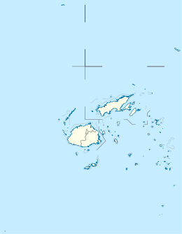
Fiji is a group of volcanic islands in the South Pacific, lying about 4,450 kilometres (2,765 mi) southwest of Honolulu and 1,770 km (1,100 mi) north of New Zealand. Of the 332 islands and 522 smaller islets making up the archipelago, about 106 are permanently inhabited. The total land size is 18,272 km2 (7,055 sq mi). It has the 26th largest Exclusive Economic Zone of 1,282,978 km2 (495,361 sq mi).
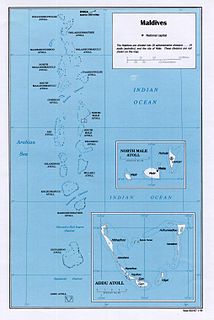
Maldives is an island country in the Indian Ocean, South Asia, south-southwest of India. It has a total land size of 298 km2 (115 sq mi) which makes it the smallest country in Asia. It consists of approximately 1,190 coral islands grouped in a double chain of 26 atolls, spread over roughly 90,000 square kilometers, making this one of the most geographically dispersed countries in the world. It has the 31st largest exclusive economic zone of 923,322 km2 (356,497 sq mi). Composed of live coral reefs and sand bars, the atolls are situated atop a submarine ridge, 960 km (600 mi) long that rises abruptly from the depths of the Indian Ocean and runs from north to south. Only near the southern end of this natural coral barricade do two open passages permit safe ship navigation from one side of the Indian Ocean to the other through the territorial waters of Maldives. For administrative purposes the Maldives government organized these atolls into twenty-one administrative divisions.

The Samoan Islands are an archipelago covering 3,030 km2 (1,170 sq mi) in the central South Pacific, forming part of Polynesia and the wider region of Oceania. Administratively, the archipelago comprises all of the Independent State of Samoa and most of American Samoa. The nearest land masses of the two Samoan jurisdictions are separated by 64 km (40 mi) of ocean.

Ducie Island is an uninhabited atoll in the Pitcairn Islands. It lies 575 kilometres (357 mi) east of Pitcairn Island, and 300 kilometres (190 mi) east of Henderson Island, and has a total area of 1.5 square miles (3.9 km2), which includes the lagoon. It is 1.5 miles (2.4 km) long, measured northeast to southwest, and about 1 mile (1.6 km) wide. The island is composed of four islets: Acadia, Pandora, Westward and Edwards.
Rose Atoll, sometimes called Rose Island or Motu O Manu by people of the nearby Manu'a Islands, is an oceanic atoll within the U.S. territory of American Samoa. An uninhabited wildlife refuge, it is the southernmost point belonging to the United States. The land area is 0.214 km2. The total area of the atoll, including lagoon and reef flat amounts to 5 km2. Just west of the northernmost point is a channel into the lagoon, about 40 m wide. There are two islets on the northeastern rim of the reef, larger Rose Island in the east and the non-vegetated Sand Island in the north.

Ono-i-Lau is a group of islands within a barrier reef system in the Fijian archipelago of Lau Islands. There are four central volcanic islands: Onolevu, Doi Lovoni and Ndavura, the uppermost parts of the volcanic edifice rising from the Lau Ridge slightly more than 1,000 metres below sea level and on which the reef and other islands are built. There are also three clusters of coral limestone islets, Yanuya and Mana on the barrier reef and Niuta. A sand cay, Udui, is not counted as one of the six “islands”.

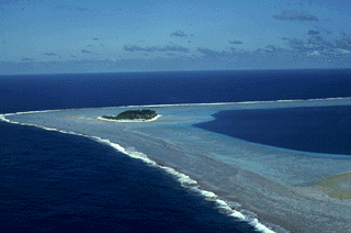
Wailagi Lala is the northernmost outpost of Fiji's Lau Islands. This tiny atoll, with an area of just 30 hectares and rising no more than 3 metres (10 ft) above mean sea level, is situated at 16.45° South and 179.6° West. It is the only true atoll in Fiji.

Conway Reef, known since 1976 by its Fijian name Ceva-I-Ra Reef,, is a coral reef of atoll type 450 km southwest of the Fiji Islands and part of the Republic of Fiji. It is at 21°44′18″S174°38′24″E. It is 2.5 km long in an east-west direction. On the middle of the reef is a small sand cay, 1.8 meters high and about 320 metres long and 73 metres wide, with a land area of two hectares. A stranded wreck of a coaster lies 240 metres south of the centre of the cay, and the wreck of a fishing vessel lies on the northeast end of the reef. The reef is uninhabited apart from birds which appear to have almost no fear of humans. Administratively, the reef is part of the Western Division, Fiji and of the Nadroga-Navosa province.

Amanu, Timanu, or Karere, is an atoll in the Tuamotu archipelago. Amanu lies at right angles to neighbouring Hao Atoll; this orientation is quite rare for the Tuamotu atolls.

Southern Maalhosmadulu Atoll is an administrative division of the Maldives. It consists of two separate natural atolls, namely the southern part of Maalhosmadulhu Atoll and the smaller natural atoll known as Goifulhafehendhu Atoll. Situated on the west of the Maldives atoll chain, it consists of 75 islands of which 13 are inhabited with a population of over 11,000 people. The remaining 57 islands are uninhabited, in addition to five islands being developed as resorts. Thulhaadhoo Island is traditionally well known for its lacquerwork handicrafts.

Anuanuraro is an atoll in French Polynesia, Pacific Ocean. It is part of the Duke of Gloucester Islands, a subgroup of the Tuamotu group. Anuanuraro's nearest neighbor is Anuanurunga, which is located about 29 km to the southeast.
Anuanurunga is an atoll in French Polynesia, Pacific Ocean. It is part of the Duke of Gloucester Islands, a subgroup of the Tuamotu group. Anuanurunga's nearest neighbor is Nukutepipi, which is located about 22 km (14 mi) to the ESE.

Nukutepipi, or Nuku-te-pipi is an atoll in French Polynesia, Pacific Ocean. It is part of the Duke of Gloucester Islands, a subgroup of the Tuamotu group. Nukutepipi's nearest neighbor is Anuanurunga, which is located about 22 km to the WNW.

Raraka, or Te Marie, is an atoll in the west of the Tuamotu group in French Polynesia. It lies 17 km to the southeast of Kauehi Atoll.

Morane is an uninhabited small isolated atoll of the Tuamotu Archipelago in French Polynesia. It is located 153 km southwest of Maria Est, its closest neighbour. Morane Atoll is the southernmost atoll of the Tuamotus proper. It measures 5.8 km in length, 3.5 km in width and has a land area of 2.85 km2. The lagoon has an area of 11 km2 and has no passes. The islands on its reef are covered with screw pine (Pandanus) and coconut trees.

Kuop or Neoch is an atoll in the state of Chuuk, Federated States of Micronesia. Its area of 0.5 km2 is uninhabited.

Ivan Mikhailovich Simonov (1794–1855) was a Russian astronomer and a geodesist.

Severe Tropical Cyclone Ula was a powerful and long-lived tropical cyclone during late December 2015 and mid-January 2016. It originated from a tropical disturbance on December 26, 2015, east of the Solomon Islands. Moving generally east, development was initially slow and the system finally reached cyclone strength—having gale-force winds—on December 30. The newly christened Tropical Cyclone Ula turned sharply south and rapidly intensified, attaining hurricane-strength the following day. A shift to the southwest brought the system close to the northern islands of Tonga on January 2, 2016. It subsequently brushed several islands in the Lau Group of Fiji before weakening. Nearly degrading to a tropical depression, Ula turned to the northwest and regained strength. After turning back to the southwest, it achieved its peak intensity as a Category 4 on the Australian scale with winds of 185 km/h (115 mph) on January 10. Thereafter, the storm bypassed Vanuatu to the southeast and New Caledonia to the east as it accelerated southward.

Tuvana-i-Colo is an uninhabited atoll in the southeastern part of the island state of Fiji in the Pacific Ocean. It is the second most southern atoll of the Lau archipelago and represents Fiji's third most southern landmass. It is located about 25 km south of Ono-i-Lau, the southernmost inhabited Fijian atoll, and 8 kilometres east-northeast of the neighboring atoll Tuvana-i-Ra. It is completely surrounded by a fringing reef.