Tuxedo was founded when land was purchased by a group of businessmen between 1903 and 1910 to establish a planned "exclusive residential-only suburban enclave."[4][5] From 1903 to 1905, the Tuxedo Park Company Limited, directed by Winnipeg-based real estate agent Frederick W. Heubach[6] on behalf of American investors Frederick E. Kenaston,[7] E. C. Warner, and Walter D. Douglas, began to purchase land for residential development. The company acquired farmland owned by Mary and Archibald Wright, along with several smaller land purchases, bringing the total area to about 1,200 hectares (3,000 acres). To transform the native scrub vegetation into what Heubach envisioned as a "Suburb Beautiful", Heubach hired Rickson A. Outhet, an architect and engineer out of New York City, to create an appropriate plan.[8] The Outhet plan was never implemented.[9]
In 1910, after acquiring additional land, Heubach and his associates formed the South Winnipeg Company, which absorbed the Tuxedo Park Company, and commissioned American landscape architects Olmsted Brothers to plan the subdivision. Their plan included a site intended for the University of Manitoba, then located in downtown Winnipeg.
Although development of the area was delayed for a variety of reasons investors continued to support the venture and several companies were created to manage land transactions and investments: Tuxedo (Winnipeg) Syndicate Limited, South Winnipeg Limited (later South Winnipeg 1923 Limited), Norwood (Winnipeg) Syndicate Limited, Warner Land Company, Tuxedo Estates Limited, Kenaston Realty Company, University Estates Limited, Assiniboine Estates Limited, Assiniboine Investments Limited, South Assiniboine Estates Limited, West Rydal Limited, and The Canadian Agency.
The Town of Tuxedo was formally incorporated on 24 January 1913, with Heubach as its first mayor and a four-member council. Other mayors included David R. Finkelstein (served 1915–1951),[10] Cecil A. R. Lamont (1952–1961),[11] and Clive K. Tallin (1961–1971).[12] The town had its own police department, fire department, and recreation commission, and was part of a health unit including St. James, Assiniboia, St. Vital, Fort Garry, and Charleswood. There were three public schools in the town, managed by the Assiniboine South School Division No. 3, including Tuxedo School No. 1709,[13] opened in 1927. Also in the late 1920s, Heubach Park was established, a purely residential subdivision within Tuxedo.[1]
The Metropolitan Planning Commission indicated as far back as 1946[14] that Grant Avenue would be extended through the Town of Tuxedo.[15] In the mid-1950s, a project to extend Grant Avenue through Tuxedo and onto Charleswood, terminating at Roblin Boulevard, would lead to the bisection of Heubach Park. However, Tuxedo mayor Cecil Lamont opposed this plan[16] and preferred that the major thoroughfare be placed southward near Eldride.[15] The Town changed its position by 1960, making way for the $50 million project, which included an additional 1,600 homes and the westward extension of Grant Avenue over the next 10 years.[17] The initial portion of the new subdivision would be located west of Heubach Park between Corydon Avenue and Mountbatten Road.
Until the 1960s, retail locations were prohibited in Tuxedo. Rules were eased to allow the construction of an apartment complex and a small shopping mall, Tuxedo Park Shopping Centre, which opened on October 30, 1963. Liquor sales followed suit in 1969.[4] A monument celebrating the incorporation of the Town was installed in Heubach Park in July 1970, dedicated by the Metropolitan Corporation of Greater Winnipeg.[18] In 1972, Tuxedo amalgamated with Winnipeg and 12 other suburbs in the Unicity scheme.[19] Records for the Tuxedo Park Company, as well as municipal records for Tuxedo, are now held at the City of Winnipeg Archives.[20]
In the early 1990s, Larry Fleisher, who then represented Tuxedo on Winnipeg City Council, requested spending $250,000 on improving Heubach Park and for the project to commence by 1993.[21] In the 2010s, commercial development of Tuxedo South led to the opening of several shopping areas, including an IKEA store, an Outlet Collection mall, and a Seasons of Tuxedo big-box cluster.[22]
Neighbourhoods
The suburb of Tuxedo contains multiple neighbourhoods. They all are part of the Assiniboine South Neighbourhood Cluster, the city ward of Charleswood-Tuxedo-Westwood, the provincial electoral district of Tuxedo, and the federal electoral district of Winnipeg South Centre.
Old Tuxedo
Old Tuxedo is a suburban neighbourhood in Winnipeg bounded by the Assiniboine River to the north, Park Boulevard North to the west, Roblin Boulevard to the south, Tuxedo Avenue to the southeast, and Route 90 to the east. It is one of the few areas that still reflects the Olmsted Company's original plan for the Town of Tuxedo.[23]
Residential development began shortly after the town's incorporation in 1913. Early building covenants limited houses to occupying no more than 40 per cent of their lots and to a maximum height of 18 m (60 ft), shaping the neighbourhood's low-density character.
The first house built in Old Tuxedo was Carey House, constructed in 1915 at 121 Park Boulevard North. Designed by architect Raymond Carey, son-in-law of developer F. W. Heubach, the three-storey residence was built for Carey and his wife, Clare.[24] The Winnipeg Architectural Society describes the house as classically inspired, with Georgian and French Classical influences expressed through its roofline, symmetry, and detailing. Carey House was still standing in 2023.
The Manitoba Agricultural College
Old Tuxedo also contains several institutional sites. The original buildings of the Manitoba Agricultural College are located in the neighbourhood and have been used as a school for the deaf, Fort Osborne Barracks, and a juvenile court.[25] The site later became part of the Asper Jewish Community Campus, which includes the Berney Theatre, Rady Centre, and Gray Academy of Jewish Education, among other organizations.[26] It was designated a provincial historic site in 1995.[25]
The neighbourhood is also home to the Manitoba Youth Centre, a provincial juvenile detention facility.[27] Nearby amenities include the Kenaston Willow Parkette.[28]
According to the 2016 Census, Old Tuxedo is 85.4 per cent Anglophone. The largest non-white groups identified were Indigenous or Métis (10.4 per cent) and Filipino (6.6 per cent). The average household income was reported as $186,161, compared with a citywide average of $44,915.[29]
Tuxedo
This neighbourhood is bordered by Corydon Boulevard to the north, Route 90 to the east, Grant Avenue to the south, and the Assiniboine Park to the West. According to the 2016 Census, the neighbourhood is 86.4% Anglophone with 10 exclusively Francophone residents.[30] The neighbourhood is majority white, with the largest non-white ethnic groups being Indigenous or Métis (3.6%). The average income of the neighbourhood is $116,538, three times higher than the city average of $44,915.
South Tuxedo
South Tuxedo's borders are Grant Avenue to the north, Route 90 to the east, the Canadian National Rail lines to the south, and Shaftesbury Avenue to the west. According to the 2016 Census, the neighbourhood is 89.7% Anglophone.[30] The neighbourhood is majority white, with the largest non-white ethnic groups being South Asian (3.6%) followed by Chinese (2.5%) and Indigenous or Métis (2.5%). The average income of the neighbourhood is $107,549, two and a half times higher than the city average of $44,915.
Tuxedo also has a large Jewish population. 33% of Winnipeg's Jewish population live in Tuxedo, with Tuxedo being home to the Asper Jewish Community Campus. 31.4% of Tuxedo's population is Jewish.[43]
Tuxedo has a low crime rate. The table below shows the crime rates of various crimes in each of the Tuxedo neighbourhoods. The crime data spans 5 years from the year 2017 to the year 2021. The rates are crimes per 100,000 residents per year. Note: The crime table includes adjacent areas (Assiniboine Park and Edgeland) not counted in the Tuxedo population figure of 7,145.
Crime rates per 100,000 people in Tuxedo neighbourhoods, 2017–2021[44]
↑Rate per 100,000 people per year: Figure is calculated by dividing the total incidents of a crime by the neighbourhood population, then multiplying by 100,000, and then dividing by 5, as the data spans 5 years
↑Aggravated assault: Includes assaults which cause bodily harm or utilize weapons; includes the following categories given on Winnipeg CrimeMaps: aggravated assault, aggravated sexual assault, assault against peace officer, assault with weapon or causing bodily harm, attempted murder, firearms offences, sexual assault with a weapon.
↑Common assault: Excludes assaults which cause bodily harm or utilize weapons; includes the following categories given on Winnipeg CrimeMaps: assault against peace officer, common assault, other assaults, sexual assault.
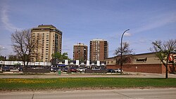
International real estate developer, financier and former Lord Mayor of London, England, Sir Denys Lowson (via South Winnipeg Development Co. Ltd.),[47] announced in March 1963[48] that Bird Construction was chosen as the company to build the Tuxedo Park Shopping Centre (2025 Corydon Avenue) designed by Smith Carter architects[49] and opened on 30 October 1963.[48] The new Centre included a 10-pin bowling alley and billiards.[50] Other initial retailers were MacIver Nanton Toys, Height Hairstylists, and Tuxedo Book & Record Shop. A Bank of Montreal branch, a Safeway supermarket, and a Shell gas station continue to operate today. The Shopping Centre was phase 1 of 2 phases on 15 acres of land, with the second phase seeing the construction of 3 apartment towers.[47]
Heubach Park (originally Olmsted Park) is a purely residential subdivision within Tuxedo that was created in the late 1920s.[5][1] Heubach Park itself comprises 26 acres of landscaped land (trees, shrubs). At one time, there was a flower bed at the southern edge of the Park at Grant Avenue, but it was later removed. As much as possible, utility wires were buried so as not to be visually cluttering.[1] Privately owned and run and situated south of Assiniboine Park, the Tuxedo Golf Course was constructed between 1932 and 1933[51] and officially opened in May 1934.[52] It features both regular 18-hole golf as well as 18-hole miniature golf runs.[53]
↑"Table I: Population of Manitoba, Saskatchewan, and Alberta by Districts, Townships, Cities, Towns, and Incorporated Villages in 1916, 1911, 1906, and 1901". Census of Prairie Provinces, 1916. Vol.Population and Agriculture. Ottawa: Government of Canada. 1918.
↑"Table 8: Population by districts and sub-districts according to the Redistribution Act of 1914 and the amending act of 1915, compared for the census years 1921, 1911 and 1901". Census of Canada, 1921. Ottawa: Government of Canada. 1922.
↑"Table 7: Population of cities, towns and villages for the province of Manitoba in census years 1901-26, as classed in 1926". Census of Prairie Provinces, 1926. Vol.Census of Manitoba, 1926. Ottawa: Government of Canada. 1927.
↑"Table 12: Population of Canada by provinces, counties or census divisions and subdivisions, 1871-1931". Census of Canada, 1931. Ottawa: Government of Canada. 1932.
↑"Table 4: Population in incorporated cities, towns and villages, 1901-1936". Census of the Prairie Provinces, 1936. Vol.I: Population and Agriculture. Ottawa: Dominion Bureau of Statistics. 1938.
↑"Table 10: Population by census subdivisions, 1871–1941". Eighth Census of Canada, 1941. Vol.II: Population by Local Subdivisions. Ottawa: Dominion Bureau of Statistics. 1944.
↑"Table 6: Population by census subdivisions, 1926-1946". Census of the Prairie Provinces, 1946. Vol.I: Population. Ottawa: Dominion Bureau of Statistics. 1949.
↑"Table 6: Population by census subdivisions, 1871–1951". Ninth Census of Canada, 1951. Vol.I: Population, General Characteristics. Ottawa: Dominion Bureau of Statistics. 1953.
↑"Table 6: Population by sex, for census subdivisions, 1956 and 1951". Census of Canada, 1956. Vol.Population, Counties and Subdivisions. Ottawa: Dominion Bureau of Statistics. 1957.
↑"Table 6: Population by census subdivisions, 1901–1961". 1961 Census of Canada. Series 1.1: Historical, 1901–1961. Vol.I: Population. Ottawa: Dominion Bureau of Statistics. 1963.
↑"Population by specified age groups and sex, for census subdivisions, 1966". Census of Canada, 1966. Vol.Population, Specified Age Groups and Sex for Counties and Census Subdivisions, 1966. Ottawa: Dominion Bureau of Statistics. 1968.
↑"Table 2: Population of Census Subdivisions, 1921–1971". 1971 Census of Canada. Vol.I: Population, Census Subdivisions (Historical). Ottawa: Statistics Canada. 1973.
This page is based on this Wikipedia article Text is available under the CC BY-SA 4.0 license; additional terms may apply. Images, videos and audio are available under their respective licenses.