
Druid Hills Historic District is a historic district in Druid Hills and Atlanta in DeKalb County, Georgia, United States, that is listed on the National Register of Historic Places (NRHP).

The National Register of Historic Places is a United States federal official list of places and sites considered worthy of preservation. In the state of Massachusetts, there are over 4,300 listings, representing about 5% of all NRHP listings nationwide and the second-most of any U.S. state, behind only New York. Listings appear in all 14 Massachusetts counties.

Dorchester Park is a historic park bounded by Dorchester Avenue, Richmond, Adams and Richview Streets in the Dorchester neighborhood of Boston, Massachusetts.
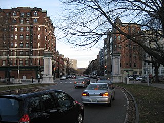
The Fenway-Boylston Street District is a historic district encompassing a series of predominantly residential buildings lining The Fenway in the Fenway–Kenmore of Boston, Massachusetts. Developed beginning in the 1890s, the area is emblematic of Boston's upper-class residential development of the period, with architect-designed houses built for some of the city's leading families. The district was listed on the National Register of Historic Places in 1984.
The Highlands Historic District is a historic district roughly bounded by June, Cherry, and Weetamoe Streets, Lincoln, Highland, President, North Main, and Hood Avenues in Fall River, Massachusetts. The district lies just north of the Lower Highlands Historic District.
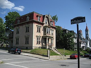
Church Street Historic District is a historic district roughly on Church Street between Park Ave. and Highland St. in Ware, Massachusetts. This mainly residential area includes some of Ware's finest late 19th century houses and a well-preserved collection of Greek Revival houses. The area was developed primarily in response to the growth of industry to the south. The district was listed on the National Register of Historic Places in 1983.

The Ware Millyard Historic District encompasses a 19th-century mill complex and industrial mill village in the town of Ware, Massachusetts. It is roughly bounded by South Street, the Ware River, Upper Dam Complex, Park Street, Otis Avenue and Church Street. The area includes surviving mill buildings, the oldest of which date to the 1840s, and a collection of tenement-style housing built for the millworkers, built between 1845 and the 1880s.

Pulaski Park is a city park along the Connecticut River in Holyoke, Massachusetts. Originally called Prospect Park when it was laid out in 1884, it was given its present name in 1939 in honor of American Revolutionary War hero Casimir Pulaski, for whom there is a memorial in the park's center. The original 5.1-acre (2.1 ha) park was designed by the Olmsted Brothers landscape design firm.

Nahant Beach Boulevard, also Nahant Causeway and Nahant Road, is a historic road on the isthmus connecting Nahant, Massachusetts to the mainland at Lynn, Massachusetts, United States. The road runs from the Lynn Rotary, its junction with Lynn Shore Drive and the Lynnway, about 1.5 miles (2.4 km) to Wilson Road in Nahant. It passes through Nahant Beach Reservation, a state park offering beach access on the isthmus. The road offers expansive views of the area coastlines and Boston Harbor. Both the park and the roadway are administered by the Massachusetts Department of Conservation and Recreation.

The Tavern Acres Historic District encompasses a residential development known as Tavern Acres, which was built in the 1920s with a landscape design by Henry Vincent Hubbard, then with the Olmsted Brothers landscape design firm. It is bounded by Bradstreet Rd., Green and Main Sts. and Park Way in North Andover, Massachusetts. The district encompasses Memorial Park, the Stevens Library, and properties facing Memorial Park and further along Bradstreet Road. The district was listed on the National Register of Historic Places in 1995.

The Middlesex Fells Reservoirs Historic District is a historic district roughly bounded by Pond St., Woodland Rd., I-93, and MA 28 in Stoneham and Medford, Massachusetts. It encompasses a portion of the Middlesex Fells Reservation, a state park managed by the Massachusetts Department of Conservation and Recreation (DCR). The principal features of the district are three reservoirs and their associated gate houses and pumping stations, which were developed by the Metropolitan District Commission starting in the late 19th century. The district was listed on the National Register of Historic Places in 1990.
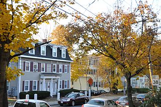
The Washington Square Historic District of Lowell, Massachusetts encompasses a historic subdivision laid out in 1832. The focal point of the subdivision is Kittridge Park, which lies on the eastern side of the district and was an original part of the subdivision plan developed by the Nesmith Brothers. It was the first significant residential subdivision in the city aimed at a wealthier clientele, and was designed by landscape architect Alexander Wadsworth. The district was added to the National Register of Historic Places in 1982, and expanded slightly in 1999.

The H. H. Richardson Historic District of North Easton is a National Historic Landmark District in the village of North Easton in Easton, Massachusetts. It consists of five buildings designed by noted 19th-century architect Henry Hobson Richardson, and The Rockery, a war memorial designed by Frederick Law Olmsted. It was declared a National Historic Landmark in 1987.

The Gray Cliff Historic District is a residential historic district encompassing a cluster of exceptionally high quality houses built in Newton, Massachusetts, between about 1890 and 1940. When first listed on the National Register of Historic Places in 1986, it included only the eight houses at 35, 39, 43, 53, 54, 64, 65, and 70 Gray Cliff Road, which were predominantly Shingle style house built before the turn of the 20th century. The district was expanded in 1990 to include an adjacent area known as The Ledges, where the houses were built between 1900 and 1940, and are mainly Colonial Revival and Tudor Revival in their styling.

The Old Chestnut Hill Historic District encompasses the historic residential heart of the Newton portion of Chestnut Hill, Massachusetts. When first listed on the National Register of Historic Places in 1986, the district extended along Hammond Street, between Beacon Street and the MBTA Green Line right-of-way, and along Chestnut Hill Road between Hammond and Essex, including properties along a few adjacent streets. The district was expanded in 1990 to include more of Chestnut Hill Road and Essex Road, Suffolk Road and the roads between it and Hammond, and a small section south of the Green Line including properties on Hammond Street, Longwood Road, and Middlesex Road. A further expansion in 1999 added a single property on Suffolk Road.
The Beacon Street Historic District is a historic district running most of the length of Beacon Street in Brookline, Massachusetts, roughly from Saint Mary's Road, near Kenmore Square, to Ayr Road near Cleveland Circle. It includes a small number of properties on adjacent streets, and was listed on the National Register of Historic Places in 1985.

The Fisher Hill Historic District encompasses a residential area in central Brookline, Massachusetts. The area was subdivided and built out beginning in the 1880s, with landscaping design by Frederick Law Olmsted and John Charles Olmsted. The district is bounded on the west by Chestnut Hill Avenue, Baxter Road, and Channing Road, and on the south by Massachusetts Route 9. Its eastern boundary runs along Buckminster Street to Dean Road, joining the northern boundary of Clinton Road, running between Dean Road and Chestnut Hill Avenue. Prior to its development in the 1880s, Fisher Hill had a relatively small number of landowners. Some of them banded together, hiring the Olmsteds to design a subdivision plan for the entire district. Lots were sold to wealthy individuals, who built fashionable houses, often designed by architects. In 1914 a restrictive covenant was entered into by a significant number of property owners, restricting their properties to strictly single-family residential uses.

Walnut Hills Cemetery is a historic cemetery on Grove Street and Allandale Road in Brookline, Massachusetts. It encompasses 45.26 acres (18.32 ha), with mature trees and puddingstone outcrops, and was laid out in 1875 in the then-fashionable rural cemetery style. Many past prominent citizens of the town, including architect H. H. Richardson, are buried here. The cemetery was listed on the National Register of Historic Places in 1985.
Boston, Massachusetts is home to many listings on the National Register of Historic Places. This list encompasses those locations that are located south of the Massachusetts Turnpike. See National Register of Historic Places listings in northern Boston for listings north of the Turnpike. Properties and districts located elsewhere in Suffolk County's other three municipalities are also listed separately.

The Chestnut Hill Historic District encompasses the historic portion of the village of Chestnut Hill that lies in Brookline, Massachusetts, with only slight overlap into adjacent Newton. The 70-acre (28 ha) district is bounded on the north by Middlesex Road, on the east by Reservoir Lane, on the south by Crafts Road and Massachusetts Route 9, and on the west by Dunster Road. A small portion of the district extends south of Route 9, including a few houses and the Baldwin School on Heath Street. The district was listed on the National Register of Historic Places on October 17, 1985.


