
The 2005 Pacific typhoon season was the least active typhoon season since 2000, producing 23 named storms, of which 13 became typhoons. It was an event in the annual cycle of tropical cyclone formation, in which tropical cyclones form in the western Pacific Ocean. The season ran throughout 2005, though most tropical cyclones typically develop between May and October. The season's first named storm, Kulap, developed on January 13, while the season's last named storm, Bolaven, dissipated on November 20. The season's first typhoon, Haitang, reached typhoon status on July 13, and became the first super typhoon of the year three days later.

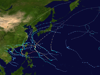
The 2007 Pacific typhoon season was a below average season which featured 24 named storms, fourteen typhoons, and five super typhoons. It was an event in the annual cycle of tropical cyclone formation, in which tropical cyclones form in the western Pacific Ocean. The season ran throughout 2007, though most tropical cyclones typically develop between May and November. The season's first named storm, Kong-rey, developed on March 30, while the season's last named storm, Mitag, dissipated on November 27. The season's first typhoon, Yutu, reached typhoon status on May 18, and became the first super typhoon of the year on the next day.

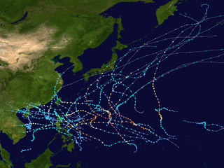
The 2004 Pacific typhoon season was an extremely active season that featured the second-highest ACE ever recorded in a single season, second only to 1997, which featured 29 named storms, nineteen typhoons, and six super typhoons. It was an event in the annual cycle of tropical cyclone formation, in which tropical cyclones form in the western Pacific Ocean. The season ran throughout 2004, though most tropical cyclones typically develop between May and October. The season's first named storm and also the first typhoon, Sudal, developed on April 4, later was reached typhoon status two days later, and became the first super typhoon of the year three days later. The season's last named storm, Noru, dissipated on December 21.

The 2003 Pacific typhoon season was a slightly below average yearlong period of tropical cyclogenesis exhibiting the development of 45 tropical depressions, of which 21 became named storms; of those, 14 became typhoons. Though every month with the exception of February and March featured tropical activity, most storms developed from May through October. During the season, tropical cyclones affected the Philippines, Japan, China, the Korean Peninsula, Indochina, and various islands in the western Pacific.

The 2002 Pacific typhoon season was a slightly above average Pacific typhoon season, producing twenty-six named storms, fifteen becoming typhoons, and eight super typhoons. It had one of the highest ACE of any season worldwide, with over 400 units. It was an event in the annual cycle of tropical cyclone formation, in which tropical cyclones form in the western Pacific Ocean. The season ran throughout 2002, though most tropical cyclones typically develop between May and October. The season's first named storm, Tapah, developed on January 11, while the season's last named storm, Pongsona, dissipated on December 11. The season's first typhoon, Mitag, reached typhoon status on March 1, and became the first super typhoon of the year four days later.

The 2001 Pacific typhoon season was the fourth and final consecutive year with below-average activity, making it the lowest four-year period of activity since 1976–1979, due to the presence of a strong La Niña that had persisted from 1998 to 2001. The season produced twenty-five named storms, sixteen typhoons and three super typhoons. It ran year-round in 2001, with most tropical cyclones in the northwestern Pacific Ocean tending between May and November.

The 1988 Pacific typhoon season had no official bounds; it ran year-round in 1988, but most tropical cyclones tend to form in the northwestern Pacific Ocean between May and November. These dates conventionally delimit the period of each year when most tropical cyclones form in the northwestern Pacific Ocean. Tropical Storms formed in the entire west Pacific basin were assigned a name by the Joint Typhoon Warning Center. Tropical depressions that enter or form in the Philippine area of responsibility are assigned a name by the Philippine Atmospheric, Geophysical and Astronomical Services Administration or PAGASA. This can often result in the same storm having two names.

The 2008 Pacific typhoon season was a below average season which featured 22 named storms, eleven typhoons, and two super typhoons. The season had no official bounds; it ran year-round in 2008, but most tropical cyclones tend to form in the northwestern Pacific Ocean between May and November. These dates conventionally delimit the period of each year when most tropical cyclones form in the northwestern Pacific Ocean.

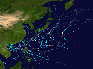
The 2012 Pacific typhoon season was a slightly above average but destructive season, though rather active since 2004. It produced 25 named storms, fourteen typhoons, and four intense typhoons. It was an event in the annual cycle of tropical cyclone formation, in which tropical cyclones form in the western Pacific Ocean. The season ran throughout 2012, though most tropical cyclones typically develop between May and October. The season's first named storm, Pakhar, developed on March 28, while the season's last named storm, Wukong, dissipated on December 29. The season's first typhoon, Guchol, reached typhoon status on June 15, and became the first super typhoon of the year on June 17.
The 2009 Pacific typhoon season was a below average season that spawned only 22 named storms, 13 typhoons, and five super typhoons. It was also recognized as the deadliest season in the Philippines for decades. The first half of the season was very quiet whereas the second half of the season was extremely active. The season's first named storm, Kujira, developed on May 3 while the season's last named storm, Nida, dissipated on December 3.
The 2010 Pacific typhoon season, with 14 named storms is the least active Pacific typhoon season on record. Seven of them strengthened into typhoons while one reached super typhoon intensity. The Pacific typhoon season during 2010 was in fact less active than the 2010 Atlantic hurricane season, with only two other occurrences of that happening, 2005 and 2020. In the same year, the Pacific hurricane season broke the same record being the least active season on record. During the season, no storms made landfall in mainland Japan, only the second such occurrence since 1988. Also, all of the 14 named storms developed west of 150°E.

Severe Tropical Storm Faxai, known in the Philippines as Tropical Storm Juaning, was a short-lived tropical storm that had minor effects on land. The twentieth named storm of the 2007 Pacific typhoon season, Faxai originated from a tropical depression over the open waters of the western Pacific Ocean in late October. The storm quickly strengthened, becoming a severe tropical storm on October 26 as it rapidly traveled toward the northeast. The storm became extratropical the following day as it brushed Japan. The remnants dissipated on October 28.

Typhoon Meranti was the first of the record nine named storms to develop during August within the 2004 Pacific typhoon season. Forming from an area of low pressure on August 3, Meranti gradually strengthened. On August 5, the storm underwent a brief period of rapid intensification, attaining its peak intensity later that day. According to the Japan Meteorological Agency, the storm attained winds of 140 km/h (87 mph) 10-minute winds) while the Joint Typhoon Warning Center reported that the storm attained winds of 165 km/h (103 mph) 1-minute winds). The following day, the typhoon quickly weakened to a tropical storm due to unfavorable conditions. By August 9, the system completed an extratropical transition; the remnants of the storm persisted until August 13, at which time it was absorbed by a large, non-tropical low.

Typhoon Kirogi, known in the Philippines as Typhoon Ditang, was a large typhoon that caused severe damage in Japan during early July 2000. Forming out of an area of disturbed weather on June 30, Kirogi initially tracked slowly towards the north. On July 3, the storm underwent rapid intensification and attained Category 4 status on the Saffir–Simpson Hurricane Scale the next day, according to the JTWC. On July 5, the Japan Meteorological Agency (JMA) assessed the storm to have reached its peak intensity with winds of 155 km/h (96 mph) 10-minute sustained) and a barometric pressure of 940 mbar. Over the following several days, the storm tracked towards the northeast and accelerated towards Japan. Early on July 8, Kirogi brushed eastern Japan before transitioning into an extratropical cyclone.
The 2011 Pacific typhoon season was a below average season that produced a total of 21 named storms, 8 typhoons, and four super typhoons. This season was much more active than the previous season, although both seasons were below the Pacific typhoon average of 26. The season ran throughout 2011, though most tropical cyclone tend to develop between May and October. The season's first named storm, Aere, developed on May 7 while the season's last named storm, Washi dissipated on December 19.
This timeline documents all of the events of the 2012 Pacific typhoon season, the period that tropical cyclones formed in the Western Pacific Ocean during 2012. Most of these tropical cyclones formed between May and November 2012. The scope of this article is limited to the Pacific Ocean, north of the equator between 100°E and the International Date Line. Tropical storms that form in the entire Western Pacific basin are assigned a name by the Japan Meteorological Agency (JMA). Tropical depressions that form in this basin are given a number with a "W" suffix by the United States' Joint Typhoon Warning Center (JTWC). In addition, the Philippine Atmospheric, Geophysical and Astronomical Services Administration (PAGASA) assigns names to tropical cyclones that enter or form in the Philippine area of responsibility. These names, however, are not in common use outside of the Philippines.

The 2022 Pacific typhoon season was the third consecutive season to have below-average tropical cyclone activity, with twenty-five named storms, although it was more active than the previous seasons by named storm count. Ten became typhoons, and three of those intensified into super typhoons. This low activity was caused by an unusually strong La Niña that had persisted from 2020. The season's first named storm, Malakas, developed on April 6, while the last named storm, Pakhar, dissipated on December 12. The season's first typhoon, Malakas, reached typhoon status on April 12. The season ran throughout 2022, though most tropical cyclones typically develop between May and October. Tropical storms Megi and Nalgae were responsible for more than half of the casualties, while typhoons Hinnamnor and Nanmadol both caused $1 billion in damages.

Typhoon Toraji, known in the Philippines as Typhoon Isang, was one of the deadliest tropical cyclones to hit the island country of Taiwan, since 1961. The eight named storm and the third typhoon of the 2001 Pacific typhoon season, Toraji's origins were from an area of convection that persisted to the west of Guam. Moving north-northwest over favorable conditions, the disturbance intensified to a tropical depression, while the JTWC issued a TCFA on the newly developed system. On July 26, the depression entered the Philippine Area of Responsibility, with the PAGASA naming it Isang. Strong easterly wind shear inhibited further development; however, as the shear relaxed, both the JTWC and PAGASA upgraded the system to a tropical storm with also the JMA following suit hours later. Now named Toraji, the storm slowly intensified, reaching typhoon status on the next day. Toraji continued to gain strength until it made landfall as a Category 2 typhoon near Taipei on July 29. Despite the rugged terrains of the country, the JTWC upgraded the system further to a Category 3, shortly before weakening as it moved offshore on Taiwan Strait. The JMA and PAGASA downgraded the typhoon to a tropical storm, with the latter issuing their final advisory as it moved out of their AOR. It continued to weaken, with the JTWC also downgrading the system to a tropical storm, before making landfall near Fuzhou on July 31 before it was last noted by the next day.

Typhoon Man-yi, known in the Philippines as Typhoon Bebeng, was a powerful tropical cyclone that battered Japan as a weakening typhoon and became the second super typhoon of the 2007 Pacific typhoon season, just after Yutu. The fourth named storm and the third typhoon of this season, Man-yi formed from a monsoon trough near the Philippines on July 5. The disturbance gradually organized and on 12:00 UTC on July 27, the JTWC issued a TCFA for the developing system. Under favorable conditions, the disturbance rapidly organized to a tropical storm, with the JMA naming it Man-yi. As it entered the Philippine Area of Responsibility on July 11, the storm explosively organized on the Philippine Sea, before passing near Okinawa on 13:00 UTC on the next day. Man-yi began to weaken on July 13 due to increasingly unfavorable conditions, before scraping southern Japan on the night of the same day. Due to the deteriorating conditions of the typhoon, the JMA and the JTWC downgraded the system to a tropical storm, before issuing their final warning as it became extratropical on July 15.

Typhoon Songda, known in the Philippines as Super Typhoon Chedeng, was the strongest tropical cyclone worldwide in 2011, an exceptionally strong and catastrophic typhoon that lashed the eastern coast of the Philippines as a Category 5–equivalent super typhoon and affected the nearby Taiwan and Japan as a weakening tropical cyclone. The fourth tropical depression, second named storm and the first super typhoon of the 2011 Pacific typhoon season, Songda formed from a non-tropical low that was embedded from the Intertropical Convergence Zone on May 17. An area of low-pressure subsequently formed and became organized for the JTWC to issue a TCFA on the system and the JMA to issue advisories, before both agencies declared it a tropical storm, earning the name Songda. Under favorable conditions, Songda slowly intensified as it entered the Philippine Area of Responsibility, with the PAGASA naming it Chedeng on May 23. On the next day, the three agencies declared the system a typhoon before rapidly intensifying to a super typhoon over the Philippine Sea. As it entered an unfavorable environment for further strengthening, Songda slowly weakened as it passed near Taiwan, before becoming extratropical near Japan. The remnants of the system slowly moved to the northeast, before absorbing to another extratropical cyclone to the south of Alaska.


