Typhoon Mitag (2002)

Last updated

Map key
  Tropical depression (≤38 mph, ≤62 km/h)
  Tropical storm (39–73 mph, 63–118 km/h)
  Category 1 (74–95 mph, 119–153 km/h)
  Category 2 (96–110 mph, 154–177 km/h)
  Category 3 (111–129 mph, 178–208 km/h)
  Category 4 (130–156 mph, 209–251 km/h)
  Category 5 (≥157 mph, ≥252 km/h)
  Unknown
Storm type
Disc Plain black.svg Tropical cyclone
Solid black.svg Subtropical cyclone
ArrowUp.svg Extratropical cyclone, remnant low, tropical disturbance, or monsoon depression

The origins of Typhoon Mitag were from a trough near the equator in late February 2002. [3] A circulation developed on February 25 south of Pohnpei, which initially had disorganized convection due to moderate wind shear. After further organization, [1] the system developed into a tropical depression on February 26. Located south of the subtropical ridge, [3] [4] it moved generally westward, intensifying into Tropical Storm Mitag near Chuuk State in the Federated States of Micronesia (FSM) on February 28. This was based on analysis from the Japan Meteorological Agency (JMA); [nb 3] [4] the Joint Typhoon Warning Center (JTWC) [nb 4] estimated that the system intensified into a tropical storm a day prior. [3] It passed just south of Weno in Chuuk while continuing westward, [6] intensifying quickly due to decreasing wind shear. [1] The JTWC upgraded the storm to a typhoon on March 1, [3] and the JMA followed suit a day later. [4]

GMS-5 visible imagery of Mitag at its peak intensity on March 5 Typhoon Mitag 2002.jpg
GMS-5 visible imagery of Mitag at its peak intensity on March 5

Despite being early in the season, Mitag intensified significantly to the east of the Philippines. [3] On March 2, an eye was observed on satellite imagery in the center of the deepest convection. Late that day, Mitag passed just south of the island of Yap in the FSM. [1] On March 3, the typhoon entered the area of warning responsibility of the Philippine Atmospheric, Geophysical and Astronomical Services Administration (PAGASA); the agency gave it the local name "Basyang". [7] An approaching deep-layer trough turned the typhoon to the northwest and later to the north. [3] Although southwesterly wind shear was expected to restrict intensification, Mitag turned to the northeast in the same direction as the shear, causing the outflow to increase. After completing an eyewall replacement cycle, very deep convection surrounded the eye, and Dvorak numbers peaked at 7.0. On this basis, the JTWC upgraded Mitag to a super typhoon on March 5, estimating peak winds of 260 km/h (160 mph)1 minute sustained) while the storm was located about 610 km (380 mi) east of Catanduanes in the Philippines. This made it the only super typhoon on record in the month [1] until Typhoon Maysak of 2015. Also on March 5, the JMA estimated peak winds of 175 km/h (109 mph)10 minute sustained), [4] PAGASA assessed the same intensity as JMA, and the National Meteorological Centre of China estimated peak winds of 205 km/h (127 mph)10 minute sustained). [7] For about a day, the typhoon maintained its peak winds, [4] before increasing wind shear and cool, dry air imparted significant weakening. In a 24‑hour period, the JTWC estimated that winds decreased by 110 km/h (68 mph)1 minute sustained) while the storm turned to the northeast, [3] and on March 7, Mitag weakened below typhoon-force. [4] A surge in the monsoon combined with the upper-level Westerlies displaced the low-level circulation from the upper-level center, causing the low-level system to turn to the east and south. On March 8, the JTWC issued its last advisory, [3] and Mitag dissipated on March 9. [4]

Impact

Tropical Storm Mitag first affected Chuuk State in the FSM, producing a wind gust of 76 km/h (47 mph) and heavy rainfall up to 176 mm (6.9 in). The rains caused a few minor landslides and flooded some homes on Weno Island. [6]

Later, Mitag passed near several islands in Yap State, first affecting Woleai. On the island, high wind gusts of around 170 km/h (110 mph) knocked out power and downed breadfruit and coconut trees. The winds destroyed a few houses, forcing residents to evacuate to a local school. Mitag dropped heavy rainfall while passing by Yap state, peaking at 255 mm (10.0 in) on Ngulu Atoll. [6] On Yap, the typhoon produced sustained winds of 56 km/h (35 mph), with gusts to 141 km/h (88 mph). [1] The winds also caused an islandwide power outage that lasted for about two days, and damaged the roof of the Yap International Airport terminal. High waves and storm surge damaged coastal structures and flooded areas up to 183 m (600 ft) inland. The seawall at the capital city of Colonia was damaged, and portions of the town were flooded 1.5 m (4.9 ft) deep. [6] The storm destroyed over 150 houses on Yap, leaving hundreds staying in shelters. [8] Across the island, the winds knocked down trees onto roads, and saltwater intrusion caused severe crop damage; most of the taro and banana crops were destroyed. Damage in the FSM totaled $150 million, of which $100 million from crop damage. [6]

Lastly, the typhoon passed about 320 km (200 mi) north of Palau, producing gusty winds but no damage. There was an indirect death on the island after a person was crushed by a tree; he had been helping a friend cut down the tree out of fear it could cause damage during the storm. [6]

Aftermath

After Mitag struck Yap, the state's governor declared a 30‑day state of emergency and asked for aid from the national government. [9] On May 29, United States President George W. Bush declared a major disaster for Yap, which allocated funding for repairing storm damage and storm damage mitigation. [10] Crop damage from Mitag caused food shortages in Yap and Chuuk, and health problems related to the storm killed one person on Nomwin. [6] Residents and businesses in Palau sent $3,000 in donations and other relief supplies to Yap, as well as $3,000 worth of oil. [11] The state government sent about $2,000 to storm victims. [12] Hospitals in Guam sent medical teams to Yap with blankets, clothing, and medical supply. [13]

See also

Notes

  1. All damage totals are in 2002  United States dollars.
  2. The Japan Meteorological Agency uses 10-minute sustained winds, while the Joint Typhoon Warning Center uses 1-minute sustained winds. The conversion factor between the two is 1.14. [2]
  3. The Japan Meteorological Agency is the official Regional Specialized Meteorological Center for the western Pacific Ocean. [4]
  4. The Joint Typhoon Warning Center is a joint United States Navy  United States Air Force task force that issues tropical cyclone warnings for the western Pacific Ocean and other regions. [5]

Related Research Articles

<span class="mw-page-title-main">2002 Pacific typhoon season</span> Typhoon season in the Western Pacific Ocean

The 2002 Pacific typhoon season was a slightly above average Pacific typhoon season, producing twenty-six named storms, fifteen becoming typhoons, and eight super typhoons. It had one of the highest ACE of any season worldwide, with over 400 units. It was an event in the annual cycle of tropical cyclone formation, in which tropical cyclones form in the western Pacific Ocean. The season ran throughout 2002, though most tropical cyclones typically develop between May and October. The season's first named storm, Tapah, developed on January 11, while the season's last named storm, Pongsona, dissipated on December 11. The season's first typhoon, Mitag, reached typhoon status on March 1, and became the first super typhoon of the year four days later.

<span class="mw-page-title-main">Typhoon Chataan</span> Pacific typhoon in 2002

Typhoon Chataan, known in the Philippines as Typhoon Gloria, was the deadliest natural disaster in the history of Chuuk, a state in the Federated States of Micronesia (FSM). The typhoon formed on June 28, 2002, near the FSM, and for several days it meandered while producing heavy rainfall across the region. On Chuuk, the highest 24-hour precipitation total was 506 mm (19.9 in), which was greater than the average monthly total. The rain produced floods up to 1.5 m (4.9 ft) deep, causing landslides across the island that killed 47 people. There was also one death on nearby Pohnpei, and damage in the FSM totaled over $100 million.

<span class="mw-page-title-main">Typhoon Isa</span> Pacific typhoon in 1997

Typhoon Isa was the first of a record eleven super typhoons to occur during the 1997 Pacific typhoon season. The second tropical cyclone of the season, Isa developed from a disturbance in the monsoon trough near the Caroline Islands on April 12. It moved erratically at first, though after attaining tropical storm status it curved westward due to the subtropical ridge to its north. Isa very gradually intensified, and on April 20 the typhoon reached peak 1-min winds of 270 km/h (170 mph), as reported by the Joint Typhoon Warning Center; Japan Meteorological Agency reported maximum 10-min winds of 155 km/h (95 mph). After turning northward, it accelerated to the northeast, and merged with a larger extratropical cyclone on April 24.

<span class="mw-page-title-main">Timeline of the 2008 Pacific typhoon season</span>

This timeline documents all the storm formations, strengthening, weakening, landfalls, extratropical transitions, as well as dissipation during the 2008 Pacific typhoon season. The 2008 Pacific typhoon season officially started on January 1, 2008 and ended on January 1, 2009. The first tropical cyclone of the season formed on January 13. The timeline also includes information which was not operationally released, meaning that information from post-storm reviews by the various warning agencies, such as information on a storm that was not operationally warned on, has been included.

<span class="mw-page-title-main">Typhoon Rammasun (2008)</span> Pacific typhoon in 2008

Typhoon Rammasun, known in the Philippines as Typhoon Butchoy, was recognized as the second typhoon of the 2008 Pacific typhoon season by the Japan Meteorological Agency (JMA) and the Philippine Atmospheric, Geophysical and Astronomical Services Administration (PAGASA). Rammasun was also recognised as the third tropical storm, the second typhoon and the first super typhoon of the 2008 Pacific typhoon season by the Joint Typhoon Warning Center (JTWC).

<span class="mw-page-title-main">
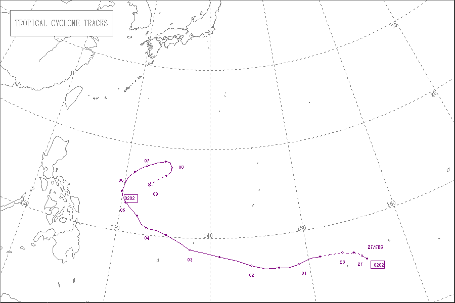
Meteorological history of Typhoon Durian</span>

Typhoon Durian's meteorological history began with its origins as a tropical disturbance near Chuuk State on November 23, 2006, and lasted until its dissipation off the coast of Andhra Pradesh, India, on December 9. Durian formed as a tropical depression on November 25 near Chuuk State. Situated south of a ridge, the system tracked west-northwest over a region characterized by low wind shear and good upper-level divergence. Late on November 26, the depression intensified into a tropical storm and was named Durian. Steady strengthening took place over the following two days as the system approached the Philippines. After attaining typhoon status on November 29, Durian underwent a period of rapid intensification, culminating with it attaining peak winds of 195 km/h (121 mph) and a barometric pressure of 915 mbar. Durian brushed the southern coast of the Catanduanes at this intensity, where a record gust of 320 km/h (200 mph) was observed.

<span class="mw-page-title-main">2014 Pacific typhoon season</span> Typhoon season in the Western Pacific Ocean

The 2014 Pacific typhoon season was a slightly below average season, featuring twenty-three tropical storms, eleven typhoons, eight super typhoons, and seven Category 5 typhoons. The season's peak months August and September saw minimal activity caused by an unusually strong and a persistent suppressing phase of the Madden–Julian oscillation (MJO). The season ran throughout 2014, though most tropical cyclones typically develop between May and October. The season began with the development of Tropical Storm Lingling on January 18, and ended after Tropical Storm Jangmi which dissipated on January 1 of the next year.

<span class="mw-page-title-main">2019 Pacific typhoon season</span> Typhoon season in the Western Pacific Ocean

The 2019 Pacific typhoon season was the costliest Pacific typhoon season on record, just ahead of the previous year. The season featured fairly above-average tropical cyclone activity for the second consecutive year, producing 29 named storms, 17 typhoons, and five super typhoons. The season's first named storm, Pabuk, reached tropical storm status on January 1, becoming the earliest-forming tropical storm of the western Pacific Ocean on record, breaking the previous record that was held by Typhoon Alice in 1979. The season's first typhoon, Wutip, reached typhoon status on February 20. Wutip further intensified into a super typhoon on February 23, becoming the strongest February typhoon on record, and the strongest tropical cyclone recorded in February in the Northern Hemisphere. The season's last named storm, Phanfone, dissipated on December 29 after it made landfall in the Philippines.

<span class="mw-page-title-main">Typhoon Sudal</span> Pacific typhoon in 2004

Typhoon Sudal, known in the Philippines as Typhoon Cosme, was the strongest typhoon to strike the island of Yap in the Federated States of Micronesia (FSM) in about 50 years. Yap is one of the four administrative divisions of the FSM. The entire island, only 17 km (11 mi) in length, experienced typhoon force winds, and 90% of the structures were damaged or destroyed. Damage was most severe in southeastern Yap, where the eyewall struck and winds exceeded 185 km/h (115 mph), but the center of the typhoon passed south of the island.

<span class="mw-page-title-main">Typhoon Lupit (2003)</span> Pacific typhoon in 2003

Typhoon Lupit, known in the Philippines as Typhoon Yoyoy, destroyed the food supply in several small islands in Yap State in the Federated States of Micronesia (FSM). It formed on November 18, 2003, from the monsoon trough to the west of the Marshall Islands. Early in its duration, it moved generally to the west or west-southwest. On November 21, the depression intensified into Tropical Storm Lupit, the 21st storm named by the Japan Meteorological Agency of the 2003 Pacific typhoon season. Two days later, it strengthened into a typhoon and developed an eye. Lupit later began a prolonged movement to the northwest, during which it passed near several islands in Yap State. The typhoon reached peak intensity on November 26, with peak 10-minute sustained winds of 185 km/h (115 mph). It later weakened due to increasing wind shear and drier air, and after recurving to the northeast, Lupit became extratropical south of Japan on December 2.

<span class="mw-page-title-main">Timeline of the 2014 Pacific typhoon season</span>

This timeline documents all of the events of the 2014 Pacific typhoon season. Most of the tropical cyclones forming between May and November. The scope of this article is limited to the Pacific Ocean, north of the equator between 100°E and the International Date Line. Tropical storms that form in the entire Western Pacific basin are assigned a name by the Japan Meteorological Agency. Tropical depressions that form in this basin are given a number with a "W" suffix by the United States' Joint Typhoon Warning Center. In addition, the Philippine Atmospheric, Geophysical and Astronomical Services Administration (PAGASA) assigns names to tropical cyclones that enter or form in the Philippine area of responsibility. These names, however, are not in common use outside of the Philippines.

<span class="mw-page-title-main">Tropical Storm Fern</span> Pacific severe tropical storm in 1996

Severe Tropical Storm Fern was a damaging storm that struck Yap in the 1996 Pacific typhoon season. A tropical depression formed on December 21, when a low-level circulation center began to produce deep convection. The depression strengthened into a tropical storm the next day, and was given the name Fern by the Joint Typhoon Warning Center (JTWC). The storm slowly intensified into a Category 1 typhoon on the Saffir–Simpson hurricane wind scale, according to JTWC. Fern peaked north of Yap on December 26, with JTWC assessing winds of 150 km/h (90 mph), while the Regional Specialized Meteorological Center, Japan Meteorological Agency (JMA) assessed peak winds of 110 km/h (70 mph), just below typhoon strength. The storm soon became sheared and weakened slowly. Fern continued to weaken to a tropical depression on December 30. Both agencies stopped advisories later on the same day.

<span class="mw-page-title-main">Tropical Storm Mekkhala (2015)</span> Pacific typhoon in 2015

Severe Tropical Storm Mekkhala, known in the Philippines as Severe Tropical Storm Amang, was an early-season tropical cyclone that made landfall over the Philippines in January 2015. Mekkhala killed three people in the Bicol Region and caused light crop damage. Notably, the storm disturbed Pope Francis’ visit to the country after the victims of Typhoon Haiyan on November 8, 2013. Although the storm also caused an airplane crash in Tacloban, nobody was hurt in the incident.

<span class="mw-page-title-main">Typhoon Maysak (2015)</span> Pacific typhoon in 2015

Typhoon Maysak, known in the Philippines as Typhoon Chedeng, was the most powerful pre-April tropical cyclone on record in the Northwestern Pacific Ocean. The fourth named storm of the 2015 Pacific typhoon season, Maysak originated as a tropical depression on March 26. The next day, the Japan Meteorological Agency (JMA) upgraded the depression to a tropical storm and assigned it the name Maysak. According to the JMA, Maysak became the second typhoon of the year on March 28. The typhoon underwent explosive intensification into a Category 5 super typhoon on March 31, passing near the islands of Chuuk and Yap in the Federated States of Micronesia. After maintaining that intensity for 18 hours, Maysak weakened, made landfall over the Philippine island of Luzon as a minimal tropical storm, and dissipated shortly afterwards.

<span class="mw-page-title-main">Typhoon Noul (2015)</span> Pacific typhoon in 2015

Typhoon Noul, known in the Philippines as Super Typhoon Dodong, was a relatively small but powerful tropical cyclone that affected several areas but caused minor damage. The sixth named storm and third typhoon of the annual typhoon season, Noul formed as a tropical depression over the eastern Caroline Islands on May 2, 2015. It moved generally to the west and west-northwest, gradually intensifying into a tropical storm and later typhoon. On May 9, Noul began rapid deepening as it developed a well-defined eye. Early the next day, the Japan Meteorological Agency (JMA) estimated peak 10 minute sustained winds of 205 km/h (125 mph), while the American-based Joint Typhoon Warning Center (JTWC) estimated peak 1 minute winds of 260 km/h (160 mph), equivalent to Category 5 on the Saffir–Simpson hurricane wind scale. Noul struck northeastern Luzon in the Philippines at that intensity and greatly weakened. After passing east of Taiwan, the typhoon accelerated to the northeast and weakened due to unfavorable conditions. On May 12, Noul became extratropical south of Japan, and the remnants continued to the northeast for several days, dissipating on May 16.

<span class="mw-page-title-main">Typhoon Dolphin (2015)</span> Pacific typhoon in 2015

Typhoon Dolphin was a powerful tropical cyclone that produced the first typhoon-force winds on Guam since Typhoon Pongsona in 2002. The seventh named storm of the 2015 Pacific typhoon season, Dolphin formed on May 6 in the vicinity of the Federated States of Micronesia (FSM). Moving eastward at first, the storm slowly organized before beginning a north and west-northwest trajectory. Dolphin intensified into a typhoon before passing between Guam and Rota on May 15, producing typhoon-force winds on both islands. It later rapidly intensified as it curved to the north. The American-based Joint Typhoon Warning Center (JTWC) designated Dolphin as a super typhoon, while the Japan Meteorological Agency (JMA) estimated 10 minute sustained winds of 185 km/h (115 mph). Dolphin turned to the northeast and weakened, becoming extratropical on May 20 and exiting the western Pacific basin on May 24.

<span class="mw-page-title-main">Tropical Storm Sanba (2018)</span> Pacific tropical storm in 2018

Tropical Storm Sanba, known in the Philippines as Tropical Storm Basyang, was a weak tropical cyclone that affected southern and central parts of the Philippines in mid-February 2018. Sanba developed as a tropical depression in the open Pacific Ocean on February 8. The system moved generally westward while slowly developing, finally attaining tropical storm status on February 11. Soon after, wind shear caused the system to lose organization and remain as a minimal tropical storm through February 11 and 12. During this time, Sanba moved westwards then west-northwestwards, making landfall over northeastern Mindanao on February 13. The system weakened into a tropical depression before making another landfall in southeastern Negros later that day. After traversing the Philippine Islands, Sanba failed to reorganize significantly in the Sulu Sea and dissipated two days later west of Palawan.

<span class="mw-page-title-main">Typhoon Percy (1990)</span> Pacific typhoon in 1990

Typhoon Percy, known in the Philippines as Typhoon Klaring, was the third tropical cyclone to affect the country in 1990. The fourth and the last tropical cyclone to be formed in June of the 1990 Pacific typhoon season, Typhoon Percy originated from an area of disturbed weather spawned by the Western Pacific monsoon trough on June 20. That same day, the disturbance was classified as a tropical depression as it slowly organized and on June 21, the depression obtained tropical storm intensity. After initially tracking westward, Percy turned towards the southwest while slowly deepening. During this time, Percy affected several of the Carolina Islands. Thirty homes were damaged and airline services were halted in and out of Yap. Farther south-southwest, seven homes were destroyed on the Ngulu Atoll. Furthermore, one boy was killed on Koror, where numerous homes lost their roofs and communication lines were downed. Percy then turned back to the west-northwest and became a typhoon on June 23. It then began to deepen at a faster rate, with Percy attaining its maximum intensity of 145 km/h (90 mph) on June 25. Two days later, on June 27, increased wind shear began to induce a weakening trend and the typhoon brushed Luzon, where eight people were killed and over 30,000 lost their homes. Despite that however, damages in the country was minor.

<span class="mw-page-title-main">Typhoon Wutip (2019)</span> Pacific typhoon in 2019

Typhoon Wutip, known in the Philippines as Tropical Depression Betty, was the most powerful February typhoon on record, surpassing Typhoon Higos of 2015. The third tropical cyclone, second tropical storm, and the first typhoon of the 2019 Pacific typhoon season, Wutip originated from a low-pressure area on February 16, 2019, that generally tracked westward, passing just south of the Federated States of Micronesia (FSM), before organizing into a tropical depression on February 18. The depression was later classified a tropical storm a day later, attaining the name Wutip from the Japan Meteorological Agency. The storm gradually intensified as it turned northwest, before it underwent rapid intensification on February 23, while passing to the southwest of Guam, and reached its first peak intensity. With winds of 270 km/h (165 mph) estimated by the Joint Typhoon Warning Center, Wutip became the first Category 5-equivalent super typhoon on record in the month of February. Wutip underwent an eyewall replacement cycle shortly afterward and weakened. The storm finished its cycle on February 24, rapidly intensifying once again. Wutip reached a secondary peak intensity the following day, again attaining Category 5-equivalent winds. Thereafter, Wutip rapidly weakened throughout its lifespan from strong wind shear as it moved northwestward, before dissipating over the Philippine Sea on March 2.

<span class="mw-page-title-main">Typhoon Jelawat (2018)</span> Pacific typhoon in 2018

Typhoon Jelawat, known in the Philippines as Tropical Storm Caloy, was a powerful typhoon that affected the Caroline Islands on March 2018. The third tropical storm and the first typhoon of the 2018 Pacific typhoon season, Jelawat originated as a tropical disturbance that struck the Federated States of Micronesia before organizing into a tropical depression on March 24. It further intensified into a tropical storm on the following day, according to the Japan Meteorological Agency, receiving the name Jelawat. Drifting northward, the storm remained unorganized while staying east of the Philippines, though environmental conditions were becoming more favorable as the storm moved along its path. On March 29, Jelawat took an unexpected sharp turn east as it intensified into a typhoon. Upon shifting northeast, Jelawat rapidly intensified on March 30 due to low vertical wind shear and substantial outflow, peaking as a Category 4-equivalent super typhoon. Shortly afterward, the storm began to weaken as wind shear sharply increased, falling below typhoon strength on March 31. The storm transitioned into a subtropical cyclone on April 1, before dissipating on that same day.

References

  1. 1 2 3 4 5 6 Gary Padgett (2002). "Monthly Global Tropical Cyclone Summary, March 2002". Archived from the original on September 1, 2011. Retrieved August 6, 2012.
  2. Joint Typhoon Warning Center (2005). "Frequently Asked Questions". Archived from the original on September 1, 2013. Retrieved July 23, 2006.
  3. 1 2 3 4 5 6 7 8 Joint Typhoon Warning Center. Super-Typhoon (STY) 02W (Mitag) (PDF) (Report). United States Navy. Archived from the original (PDF) on February 21, 2013. Retrieved July 25, 2012.
  4. 1 2 3 4 5 6 7 8 Annual Report on Activities of the RSMC Tokyo – Typhoon Center 2002 (PDF) (Report). Japan Meteorological Agency. 8. Archived from the original (PDF) on October 14, 2013. Retrieved July 24, 2012.
  5. "Joint Typhoon Warning Center Mission Statement". Joint Typhoon Warning Center. 2011. Archived from the original on July 26, 2007. Retrieved July 25, 2012.
  6. 1 2 3 4 5 6 7 "Storm Data and Unusual Weather Phenomena with Late Reports and Corrections" (PDF). 44 (3). National Oceanic and Atmospheric Administration. March 2002: 134–136. Retrieved August 7, 2012.{{cite journal}}: Cite journal requires |journal= (help)[ permanent dead link ]
  7. 1 2 Gary Padgett (2002). "Monthly Global Tropical Cyclone Tracks, March 2002". Archived from the original on September 1, 2011. Retrieved August 6, 2012.
  8. "Micronesia - Typhoon Mitag OCHA Situation Report No. 1". ReliefWeb. UN Office for the Coordination of Humanitarian Affairs. March 4, 2002. Archived from the original on October 29, 2019. Retrieved August 7, 2012.
  9. "Federated States of Micronesia: Typhoon Mitag information bulletin No.01/02". ReliefWeb. International Red Cross and Red Crescent Movement. March 4, 2002. Archived from the original on August 20, 2016. Retrieved August 7, 2012.
  10. President Declares Major Disaster For Micronesia (Report). Federal Emergency Management Agency. May 29, 2002.
  11. Jowie C. Aquino (May 3, 2002). "Yap welcomes Palau's contributions". Palau Horizon. Retrieved August 7, 2012.
  12. "Relief goods for Yap ready for shipment". Palau Horizon. April 9, 2002. Retrieved August 7, 2012.
  13. Susan M. Koerner (March 30, 2002). "Guam Naval Hospital Helps Remote Islands Residents". Navy News Service. Archived from the original on November 1, 2019. Retrieved August 7, 2012.
Typhoon Mitag (Basyang)
Mitag 2002-03-05 1400Z.jpg
Mitag at peak intensity on March 5