
Cilacap Regency is a regency in the southwestern part of Central Java province in Indonesia. Its capital is the town of Cilacap, which had 260,376 inhabitants in mid 2023, spread over three administrative districts.

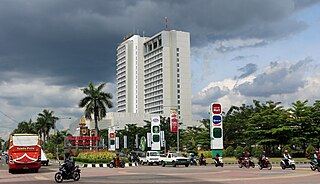
Cilegon is a major coastal industrial city in Banten province, Indonesia, covering 162.51 km2 (62.75 sq mi). It is located on the island of Java. The city had a population of 374,464 at the 2010 Census and 434,896 at the 2020 Census; the official estimate as at mid 2023 was 470,378.

Tegal is a city in the northwest part of Central Java of Indonesia. It is situated on the north coast of the province of Central Java, about 175 km (109 mi) from Semarang, the capital of the province. It had a population of 239,599 at the 2010 Census and 273,825 at the 2020 Census; the official estimate as of the start of 2024 was 293,818.

Kuningan is a town and district located in eastern West Java, Indonesia, between Cirebon and Tasikmalaya, about 200 km east of Jakarta. It is the administrative center of Kuningan Regency. The district is located east of Mount Cereme/Ciremai, the highest mountain in West Java. The eastern part of the district is a valley. The district's landmark is a statue of a horse, called Kuda Kuningan and its motto is Kuningan Aman (Safe) Sehat (Healthy) Rindang (Leafy) Indah (Beautiful), abbreviated as Kuningan ASRI.

Wonosobo Regency is a regency in Central Java province in Indonesia. The regency seat is located in the town of Wonosobo, located at 7.3684940°S 109.8983841°E,on the Dieng Plateau, about 120 km from Semarang City. Wonosobo Regency shares borders with Temanggung and Magelang Regencies to the east, Purworejo Regency to the south, Kebumen Regency and Banjarnegara Regency to the west, and Batang Regency and Kendal Regency to the north. The regency's area is 984.68 km2 and its population was 754,883 at the 2010 census and 879,124 at the 2020 census; the official estimate as at mid 2023 was 909,664.

Klaten Regency is a regency in Central Java province in Indonesia. It covers an area of 701.52 km2 and had a population of 1,130,047 at the 2010 Census and 1,260,506 at the 2020 Census; the official estimate as at mid 2023 was 1,284,386. Its administrative centre is in the town of the same name; the town extends over 35.85 km2 to encompass three of the regency's districts, with a combined total of 135,681 inhabitants in mid 2023; a fourth district (Kalikotes) is part of its urban area.
Boyolali is a regency in the eastern part of Central Java province in Indonesia. It covers an area of 1,015.10 km2, and had a population of 930,531 at the 2010 census and 1,062,713 at the 2020 census; the official estimate as at mid 2023 was 1,090,131, comprising 547,713 males and 542,416 females. The administrative centre is the town of Boyolali.

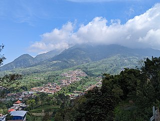
Magelang is a regency in Central Java, Indonesia, famous for its 9th century Buddhist temple of Borobudur. Its capital is Mungkid. It covers an area of 1,085.73 km2 and had a population of 1,181,723 at the 2010 Census and 1,299,859 at the 2020 Census; the official estimate as at mid 2023 was 1,330,656. These figures exclude the autonomous city of Magelang, which is separately administered but is geographically enclaved within the regency, which borders Temanggung Regency to the north, Semarang Regency to the northeast, Boyolali Regency to the east, the Special Region of Yogyakarta to the south and southeast, Purworejo Regency to the southwest, and Wonosobo Regency to the west.

Sumenep, officially the Sumenep Regency, was previously spelled as Samanap or Zamanap in English, is a regency of the East Java province, Indonesia. It has an area of 2,093.47 square kilometres and the population of 1,142,210 as of 2023. The administrative capital is Kota Sumenep. Since 2014, Sumenep Regency has been recognized by UNESCO as the area that has the most Mpu in the world and most of them are in Aeng Tong-Tong Village, Saronggi District.

Indramayu, named after the God Indra, is a town and district which serves as the capital of Indramayu Regency in the West Java province of Indonesia, and is located in the northern coastal area of West Java, east from Jakarta, north-east from the city of Bandung, and north-west of the city of Cirebon. Most of its land are situated below sea level, which makes the district vulnerable to high tide in stormy conditions. The district is only protected by some dunes and barrages at the seaside.

Purwakarta is a town and an administrative district (kecamatan) in West Java, Indonesia which serves as the regency seat of the Purwakarta Regency. It covers a land area of 24.39 km2, and had a population of 165,447 at the 2010 Census, rising to 179,233 at the 2020 Census; the official estimate as at mid 2023 was 183,813 - comprising 92,178 males and 91,635 females.

Pandeglang Regency is a regency of Banten province, Indonesia. It is mainly located on the west and south coasts of the island of Java and is the most westerly regency on Java Island, but it also includes several offshore islands such as Panaitan, Peucang, Deli and Tinjil. It is bounded by Serang Regency to the north, Lebak Regency to the east, the Java Sea to the south, and the Sunda Strait to the west. The regency has a land area of 3,053.13 km2, and a population at the 2010 Census of 1,149,610, rising to 1,272,687 at the 2020 Census; the official estimate as of mid-2023 was 1,391,056. The regency seat is the town of Pandeglang in the northeast of the regency, but the most densely-populated district outside of the northeast agglomeration is the town of Labuan on the west coast.
Sukoharjo Regency is a regency in the Central Java province in Indonesia. It covers an area of 493.23 km2 and had a population of 824,238 at the 2010 Census and 907,587 at the 2020 Census; the official estimate as of mid-2023 was 932,680. Its administrative centre is in the town of Sukoharjo, about 10 km south of Surakarta. This regency is bordered by the city of Surakarta in the north, Karanganyar Regency in the east, Wonogiri Regency and Yogyakarta in the south as well as Klaten Regency in the west. The regency is part of the metropolitan zone of Surakarta, which is known as Subosukawonosraten.

Ambarawa is a town and an administrative district (kecamatan) of the Semarang Regency, located between the cities of Semarang and Salatiga in Central Java Province of Indonesia. Administratively, it is bordered by the districts of Banyubiru to the south, Jambu to the west, Bandungan to the north, and Bawen to the east.

Temanggung Regency is an inland regency in the Central Java Province of Indonesia. It covers a land area of 870.65 km2 and had a population of 708,546 at the 2010 Census and 790,174 at the 2020 Census; the official estimate as of mid-2023 was 808,446, comprising 406,100 males and 402,346 females. Its capital is the town of Temanggung.
Rembang Regency is a regency on the extreme northeast coast of Central Java Province, on the island of Java in Indonesia. The regency covers an area of 1,036.70 km2 on Java, and it had a population of 591,359 at the 2010 Census and 645,333 at the 2020 Census; the official estimate as of mid-2023 was 660,166, of whom 331,870 were males and 328,296 were females. Its administrative capital is the town of Rembang.
Sragen Regency is a regency in the eastern part of Central Java province in Indonesia. It covers an area of 994.57 km2 and had a population of 858,266 at the 2010 Census and 976,951 at the 2020 Census; the official estimate as at mid 2023 was 997,485. Its capital is the town of Sragen, located about 30 km to the northeast of Surakarta. Sragen is bordered by East Java Province to the east.

Semarang is a landlocked regency in Central Java province in Indonesia. It covers an area of 1,019.27 km2 and had a population of 930,727 at the 2010 census and 1,053,094 at the 2020 census; the official estimate at mid 2023 was 1,080,648, comprising 538,117 males and 542,531 females. These figures exclude the independent cities of Semarang and Salatiga, which are administratively separate from the regency. The regency's capital is Ungaran, which lies immediately to the south of Semarang City.

Kudus is the capital and the namesake of the Kudus Regency in Central Java, Indonesia. Its name has an Arabic etymology connected to its foundation by the legendary figure Sunan Kudus. It also houses the mosque established by Sunan Kudus named Menara Kudus Mosque, one of the most important and influential mosques in Indonesia. According to the 2010 census, its population was 92,776, but by mid-2022 this had declined to 88,635.

The Semarang metropolitan area, known locally as Kedungsepur, is a metropolitan area anchored by the city of Semarang in Central Java, Indonesia. It additionally includes the city of Salatiga, as well as Demak Regency, Grobogan Regency, Kendal Regency, and Semarang Regency. It is the fourth most populous metropolitan area in Indonesia with an estimated population of about 6.2 million as at mid 2023.

