
Brighton is a former town and current neighborhood of Boston, Massachusetts, United States, located in the northwestern corner of the city. It is named after the English city of Brighton. Initially Brighton was part of Cambridge, and known as "Little Cambridge". Brighton separated from Cambridge in 1807 after a bridge dispute, and was annexed to Boston in 1874. For much of its early history, it was a rural town with a significant commercial center at its eastern end.
Allston is an officially recognized neighborhood in Boston, Massachusetts, United States. It was named after the American painter and poet Washington Allston. It comprises the land covered by the zip code 02134. For the most part, Allston is administered collectively with the adjacent neighborhood of Brighton. The two are often referred to together as Allston–Brighton. Boston Police Department District D-14 covers the Allston-Brighton area and a Boston Fire Department Allston station is located in Union Square which houses Engine 41 and Ladder 14. Engine 41 is nicknamed "The Bull" to commemorate the historic stockyards of Allston.
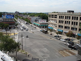
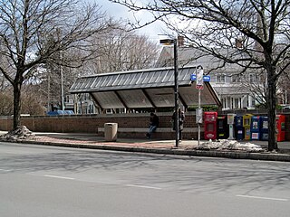
Packard's Corner is located in Boston, Massachusetts at the intersection of Commonwealth Avenue and Brighton Avenue. Packard's Corner is serviced by the Packards Corner stop on the B branch of the MBTA's Green Line, a light rail line that runs mostly above ground.

The Boston Elevated Railway (BERy) was a streetcar and rapid transit railroad operated on, above, and below, the streets of Boston, Massachusetts and surrounding communities. Founded in 1894, it eventually acquired the West End Street Railway via lease and merger to become the city's primary mass transit provider. Its modern successor is the state-run Massachusetts Bay Transportation Authority (MBTA), which continues to operate in part on infrastructure developed by BERy and its predecessors.

Key bus routes of the Massachusetts Bay Transportation Authority (MBTA) system were the 15 routes that had high ridership and higher frequency standards than other bus lines, according to the 2004 MBTA Service Policy. Together, they accounted for roughly 40% of the MBTA's total bus ridership. These key bus routes ensured basic geographic coverage with frequent service in the densest areas of Boston, and connected to other MBTA services to give access to other areas throughout the region.

The E branch is a light rail line in Boston, Cambridge, Medford, and Somerville, Massachusetts, operating as part of the Massachusetts Bay Transportation Authority (MBTA) Green Line. The line runs in mixed traffic on South Huntington Avenue and Huntington Avenue between Heath Street and Brigham Circle, in the median of Huntington Avenue to Northeastern University, then into the Huntington Avenue subway. The line merges into the Boylston Street subway just west of Copley, running to North Station via the Tremont Street subway. It then follows the Lechmere Viaduct to Lechmere, then the Medford Branch to Medford/Tufts. As of February 2023, service operates on eight-minute headways at weekday peak hours and eight to nine-minute headways at other times, using 13 to 17 trains.

The B branch, also called the Commonwealth Avenue branch or Boston College branch, is a branch of the MBTA Green Line light rail system which operates on Commonwealth Avenue west of downtown Boston, Massachusetts. One of four branches of the Green Line, the B branch runs from Boston College station down the median of Commonwealth Avenue to Blandford Street. There, it enters Blandford Street portal into Kenmore station, where it merges with the C and D branches. The combined services run into the Boylston Street subway and Tremont Street subway to downtown Boston. B branch service has terminated at Government Center since October 2021. Unlike the other branches, B branch service runs solely through the city limits of Boston. The Green Line Rivalry between Boston College and Boston University is named in reference to the B branch, which runs to both universities.
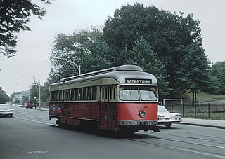
The A branch or Watertown Line was a streetcar line in the Boston, Massachusetts, area, operating as a branch of the Massachusetts Bay Transportation Authority Green Line. The line ran from Watertown through Newton Corner, Brighton, and Allston to Kenmore Square, then used the Boylston Street subway and Tremont Street subway to reach Park Street station.

As with many large cities, a large number of Boston-area streetcar lines once existed, and many continued operating into the 1950s. However, only a few now remain, namely the four branches of the Green Line and the Mattapan Line, with only one running regular service on an undivided street.
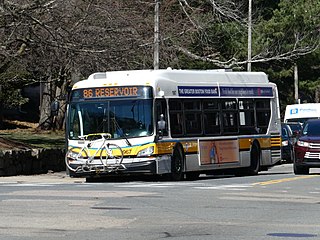
Route 86 is a local bus route in Boston and Cambridge operated by the Massachusetts Bay Transportation Authority (MBTA) as part of MBTA bus service. It operates between Reservoir station and Harvard station, via Lower Allston and Brighton Center. In 2018, it had the 18th-highest weekday ridership on the system, though it ranked 37th by number of weekday trips. A 2018–19 MBTA review of its bus system found that route 86 had infrequent and unreliable service, including irregular scheduled headways, despite its high ridership and significance as a crosstown connecting route.
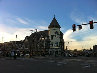
Coolidge Corner is a neighborhood of Brookline, Massachusetts, United States, centered on the intersection of Beacon Street and Harvard Street. The neighborhood takes its name from the Coolidge & Brother general store that opened in 1857 at that intersection at the site of today's S.S. Pierce building, which was for many years the only commercial business in north Brookline.

Wood Island station is an MBTA Blue Line rapid transit station located off Bennington Street in the Day Square section of East Boston, Boston, Massachusetts. The station is adjacent to and named for the former Wood Island Park, a once heavily used recreational area for East Boston residents. Most of the park was destroyed in the mid 1960s to expand Logan International Airport. It was built in 1952, replacing a pair of Boston, Revere Beach and Lynn Railroad stations that served the area.
Washington Square is a neighborhood in Brookline, Massachusetts, United States.

The Honan-Allston branch of the Boston Public Library is located at 300 North Harvard Street in Lower Allston. The 57,000 square feet (5,300 m2) building opened in 2001 at a cost of $6.5 million, replacing a former branch closed in 1981. The library itself contains an area of 20,000 square feet (1,900 m2). The materials used to build the library include slate panels, shingles and rough sculpings, unfinished iron-wood cladding, and wood windows.
Brigham Circle is located at the intersection of Tremont Street and Huntington Avenue in the Mission Hill neighborhood of Boston, Massachusetts. The commercial center of Mission Hill, it forms the southern tip of the Longwood Medical Area.

Boston Landing station is an MBTA Commuter Rail station in Boston, Massachusetts, United States. It is served by the Framingham/Worcester Line. It is located in the Brighton neighborhood just west of the Everett Street bridge, next to the Massachusetts Turnpike. It serves the Allston-Brighton area as well as the Boston Landing development including Warrior Ice Arena. The station is fully accessible, with a single full-length high-level island platform. Elevators and stairs lead to Arthur Street and to the Everett Street bridge.

Union Square station was a streetcar stop on the Green Line A branch located at Union Square in the Allston neighborhood of Boston, Massachusetts. It was closed in 1969 when service on the line was suspended and replaced by buses.
Newton Corner is an MBTA bus transfer point in the Newton Corner neighborhood of Newton, Massachusetts, located on the rotary where Washington Street crosses the Massachusetts Turnpike. The Newton Corner station, known simply as Newton for much of its lifetime, served commuters on the Worcester Line from 1834 to 1959. A streetcar stop, located on the surface streets, served a number of routes beginning in 1863, including the Green Line A branch until 1969. Newton Corner is now a stop and transfer point for MBTA routes 52, 57, 501, 504, 553, 554, 556, and 558, which include express routes to downtown Boston as well as local routes, with stops on the north and south sides of the rotary.

Beacon Park Yard was a CSX Transportation rail yard in Allston, Boston, now owned by Harvard University. The yard opened in 1890 on the site of a former trotting park, from which it took its name. It was closed in 2013 following the relocation of the yard's container operations to Worcester, Massachusetts, and opening of a transload facility in Westborough, Massachusetts. Plans for the yard include relocation of the Massachusetts Turnpike Allston exit, construction of a new MBTA commuter rail station, a major real estate development, and possibly a rail layover yard.

The Ipswich Street line was a streetcar line in Boston and Brookline, Massachusetts. The line ran on Boylston Street and Ipswich Street in the Fenway–Kenmore neighborhood, and on Brookline Avenue through what is now the Longwood Medical Area to Brookline Village.

