Union Township, Sheridan County, Kansas

Last updated

Union Township
USA Kansas location map.svg
Red pog.svg
Union Township
Coordinates: 39°31′30″N100°22′47″W / 39.52500°N 100.37972°W / 39.52500; -100.37972
Country United States
State Kansas
County Sheridan
Area
[1]
  Total35.70 sq mi (92.5 km2)
  Land35.70 sq mi (92.5 km2)
  Water0 sq mi (0 km2)  0%
Elevation
2,625 ft (800 m)
Population
 (2010)
  Total42
  Density1.2/sq mi (0.45/km2)
GNIS ID 471109 [2]

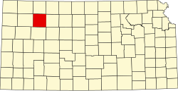
Union Township is a township in Sheridan County, Kansas, United States. As of the 2010 Census, it had a population of 42. [3]

Related Research Articles

<span class="mw-page-title-main">Shelby County, Iowa</span> County in Iowa, United States

Shelby County is a county located in the U.S. state of Iowa. As of the 2020 census, the population was 11,746. The county seat is Harlan. Its name is in honor of Isaac Shelby, the first Governor of Kentucky.

<span class="mw-page-title-main">Vernon County, Missouri</span> County in Missouri, United States

Vernon County is located in the western region of the U.S. state of Missouri, on the border with Kansas. As of the 2020 census, the population was 19,707. Its county seat is Nevada. The county was organized on February 27, 1855, considerably later than counties in the eastern part of the state. It was named for Colonel Miles Vernon (1786–1867), a state senator and veteran of the Battle of New Orleans. This area was part of the large historic territory of the Osage Nation of Native Americans.

<span class="mw-page-title-main">Guthrie County, Iowa</span> County in Iowa, United States

Guthrie County is a county located in the U.S. state of Iowa. As of the 2020 census, the population was 10,623. The county seat is Guthrie Center. The county was formed on January 15, 1851, and named after Captain Edwin B. Guthrie, who died in the Mexican–American War.

<span class="mw-page-title-main">Union County, Arkansas</span> County in Arkansas, United States

Union County is a county located on the central southern border of the U.S. state of Arkansas. As of the 2020 census, the population was 39,054. The county seat is El Dorado. The county was formed on November 2, 1829, and named in recognition of the citizens' petition for a new county, which said that they were petitioning "in the spirit of Union and Unity." The county is directly adjacent to the south to Union Parish in the state of Louisiana.

<span class="mw-page-title-main">Sharp County, Arkansas</span> County in Arkansas, United States

Sharp County is a county located in the U.S. state of Arkansas. As of the 2020 census, the population was 17,271. The county seat is Ash Flat. The county was formed on July 18, 1868, and named for Ephraim Sharp, a state legislator from the area.

<span class="mw-page-title-main">Saline County, Arkansas</span> County in Arkansas, United States

Saline County is located in the U.S. state of Arkansas. As of the 2020 census, the population was 123,416. Its county seat and largest city is Benton. Saline County was formed on November 2, 1835, and named for the salt water (brine) springs in the area, despite a differing pronunciation from saline. Until November 2014, it was an alcohol prohibition or dry county.

<span class="mw-page-title-main">Perry County, Arkansas</span> County in Arkansas, United States

Perry County is a county located in the U.S. state of Arkansas. Its population was 10,019 at the 2020 United States Census. The county seat is Perryville. The county was formed on December 18, 1840, and named for Commodore Oliver Hazard Perry, naval hero in the War of 1812. It is an alcohol prohibition or dry county.

<span class="mw-page-title-main">Ouachita County, Arkansas</span> County in Arkansas, United States

Ouachita County is a county located in the south central part of the U.S. state of Arkansas. As of the 2020 census, the population was 22,650.

<span class="mw-page-title-main">Madison County, Arkansas</span> County in Arkansas, United States

Madison County is a county located in the U.S. state of Arkansas. As of the 2020 census, the population was 16,521. The county seat is Huntsville. The county was formed on September 30, 1836, and named for Madison County, Alabama, the home of some early settlers. They also named the county seat after Madison County in Alabama's county seat, Huntsville.

<span class="mw-page-title-main">Jackson County, Arkansas</span> County in Arkansas, United States

Jackson County is located in the Arkansas Delta in the U.S. state of Arkansas. The county is named for Andrew Jackson, a national hero during the War of 1812. By the county's formation in 1829, Jackson had become the seventh President of the United States. Jackson County is home to seven incorporated towns and four incorporated cities, including Newport, the largest city and county seat. The county is also the site of numerous unincorporated communities and ghost towns. Occupying 633.94 square miles (164,190 ha), Jackson County is the 41st largest county of the 75 in Arkansas. As of the 2020 Census, the county's population was 16,755. Based on population, the county is the 44th-largest county in Arkansas. Although terrain rises in the west, most of Jackson County is within the Arkansas Delta, characterized by largely flat terrain with fertile soils. Historically covered in forest, bayous and swamps, the area was cleared for agriculture by early settlers. It is drained by the White River.

<span class="mw-page-title-main">Izard County, Arkansas</span> County in Arkansas, United States

Izard County is a county located in the U.S. state of Arkansas. As of the 2020 census, the population was 13,577. The county seat is Melbourne. Izard County is Arkansas's 13th county, formed on October 27, 1825, and named for War of 1812 General and Arkansas Territorial Governor George Izard. It is an alcohol prohibition or dry county.

<span class="mw-page-title-main">Independence County, Arkansas</span> County in Arkansas, United States

Independence County is a county located in the U.S. state of Arkansas. As of the 2020 census, the population was 37,938. The county seat is Batesville. Independence County is Arkansas's ninth county, formed on October 20, 1820, from a portion of Lawrence County and named in commemoration of the Declaration of Independence. It is an alcohol prohibition or dry county.

<span class="mw-page-title-main">Columbia County, Arkansas</span> County in Arkansas, United States

<span class="mw-page-title-main">Union Township, Hunterdon County, New Jersey</span> Township in Hunterdon County, New Jersey, United States

Union Township is a township in Hunterdon County, in the U.S. state of New Jersey. The southwest half of the township lies on what is known as the Hunterdon Plateau, the northwest corner consists of the Musconetcong Ridge and the northeast section is part of the lower-lying Newark Basin around Spruce Run Reservoir. As of the 2020 United States census, the township's population was 6,507, its highest ever decennial count and an increase of 599 (+10.1%) from the 2010 census count of 5,908, which in turn reflected a decline of 252 (−4.1%) from the 6,160 counted in the 2000 census.

<span class="mw-page-title-main">East Uniontown, Pennsylvania</span> Census-designated place in Pennsylvania, United States

East Uniontown is a census-designated place (CDP) in Fayette County, Pennsylvania, United States. The population was 2,419 at the 2010 census, down from 2,760 at the 2000 census.

<span class="mw-page-title-main">Wilkins Township, Allegheny County, Pennsylvania</span> Township in Pennsylvania, United States

Wilkins Township is a township in Allegheny County, Pennsylvania, United States. The population was 6,357 at the 2010 census. It is served by Pennsylvania's 12th congressional district, the 43rd District of the Pennsylvania State Senate, and the 34th District of the Pennsylvania State House of Representatives.

<span class="mw-page-title-main">Union Township, Auglaize County, Ohio</span> Township in Ohio, United States

Union Township is one of the fourteen townships of Auglaize County, Ohio, United States. The 2020 census found 1,746 people in the township.

<span class="mw-page-title-main">Abbotts Creek Township, Forsyth County, North Carolina</span>

Abbotts Creek Township is one of fifteen townships in Forsyth County, North Carolina, United States. The township had a population of 11,310 according to the 2010 census.

Allenwood is a census-designated place in Gregg Township, Union County, Pennsylvania, United States. As of the 2010 census, its population was 321. Federal Correctional Complex, Allenwood is located here.

References

  1. "US Gazetteer files: 2010, 2000, and 1990". United States Census Bureau. February 12, 2011. Retrieved April 23, 2011.
  2. "Township of Union". Geographic Names Information System . United States Geological Survey, United States Department of the Interior.
  3. "U.S. Census website". United States Census Bureau . Retrieved May 14, 2011.