
Harvard Yard is the oldest and among the most prominent parts of the campus of Harvard University in Cambridge, Massachusetts. The yard has a historic center and modern crossroads and contains most of the freshman dormitories, Harvard's most important libraries, Memorial Church, several classroom and departmental buildings, and the offices of senior university officials, including the President of Harvard University.

Harvard Square is a triangular plaza at the intersection of Massachusetts Avenue, Brattle Street and John F. Kennedy Street near the center of Cambridge, Massachusetts, United States. The term "Harvard Square" is also used to delineate the business district and Harvard University surrounding that intersection, which is the historic center of Cambridge. Adjacent to Harvard Yard, the historic heart of Harvard University, the Square functions as a commercial center for Harvard students, as well as residents of western Cambridge, the western and northern neighborhoods and the inner suburbs of Boston. The Square is served by Harvard station, a major MBTA Red Line subway station and a bus transportation hub.

New Bedford Whaling National Historical Park is a United States National Historical Park in New Bedford, Massachusetts, and is maintained by the National Park Service (NPS). The park commemorates the heritage of the world's preeminent whaling port during the nineteenth century.

Massachusetts Avenue is a major diagonal transverse road in Washington, D.C., and the Massachusetts Avenue Historic District is a historic district that includes part of it.
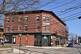
Newton Upper Falls is one of the thirteen villages within the city of Newton in Massachusetts, United States. The village is listed as the Newton Upper Falls Historic District on the National Register of Historic Places.

The Charles River Reservation is a 17-mile-long (27 km) urban preserve and public recreation area located along the banks of the Charles River in Boston, Cambridge, Watertown, and Newton, Massachusetts. The reservation is managed by the Massachusetts Department of Conservation and Recreation.

The Central Park West Historic District is located along Central Park West, between 61st and 97th Streets, on the Upper West Side of Manhattan in New York City, United States. The district was added to the National Register of Historic Places on November 9, 1982. The district encompasses a portion of the Upper West Side-Central Park West Historic District as designated by the New York City Landmarks Preservation Commission, and contains a number of prominent New York City designated landmarks, including the Dakota, a National Historic Landmark. The buildings date from the late 19th century to the early 1940s and exhibit a variety of architectural styles. The majority of the district's buildings are of neo-Italian Renaissance style, but Art Deco is a popular theme as well.

The Bigelow Street Historic District encompasses a uniform collection of 19th century houses on most of the length of Bigelow Street in Cambridge, Massachusetts, just northwest of Central Square. Bigelow Street was laid out in 1868, and the street was almost completely built out by 1874, resulting in a fairly uniform streetscape of Second Empire architecture. The district was added to the National Register of Historic Places in 1982.

The City Hall Historic District is a historic district encompassing buildings important in the early growth of the Central Square area of Cambridge, Massachusetts. The focal point of the district is the monumental Richardsonian Romanesque Cambridge City Hall building on the north side of Massachusetts Avenue, two block west of the heart of the square. It also includes four buildings in the block just east of city hall, which is bounded by Bigelow and Temple Streets, Inman and Richard Allen Drives. City Hall was built in 1888 to a design by Longfellow, Alden & Harlow. Other buildings in the district include the Syrian Orthodox Catholic Church, built in 1822 and moved to 8 Inman Street from Lafayette Square in 1888, the 1888 Cambridge Mutual Fire Insurance Building at 763 Mass. Avenue, the 1912 Cambridge Electric Light Company Building at 719 Mass. Avenue, and the 1910 Cambridge YWCA at 7 Temple Street.

The Old Cambridgeport Historic District is a historic district along Cherry, Harvard and Washington Streets in Cambridge, Massachusetts. It contains some of the oldest surviving houses north of Massachusetts Avenue in the Cambridgeport section of the city. It includes the entire block of Cherry Street between Harvard and Washington Streets, as well as a few buildings on those two streets. The oldest houses are the Samuel Fay House and the Margaret Fuller House.

The Salem–Auburn Streets Historic District is a residential historic district at Salem and Auburn Streets in Cambridge, Massachusetts. The district includes a collection of houses that is among the oldest in the Cambridgeport section of the city, and includes most of the houses on two blocks of these streets. The district was added to the National Register of Historic Places in 1982.

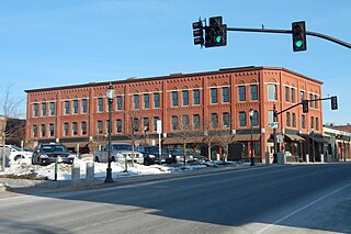
The Upper Worthington Historic District of Springfield, Massachusetts encompasses a collection of visually cohesive residential apartment blocks that represent one of the largest residential developments in the city dating to the first three decades of the 20th century. It is centered on a portion of Worthington Street, a major east-west road in the city, between Armory Street and Summit Street, and includes 33 buildings on those three streets as well as Federal and Taylor Streets, near their junctions with either Worthington or Federal. Most of the contributing buildings are four story brick buildings with Georgian detailing and stone trim. The district was first listed on the National Register of Historic Places in 1983, including 28 buildings; the district was expanded in 1992 to add the five buildings on Taylor Street.

The Carlton House Block is a historic commercial and retail block at 9-13 Hampden Street in Springfield, Massachusetts. Built in 1873, and updated in the early 20th century, it is a good example of Italianate architecture, built during the downtown's development as an industrial and commercial center. The building was listed on the National Register of Historic Places in 1983.

The North Canal Historic District of Lawrence, Massachusetts, encompasses the historic industrial heart of the city. It is centered on the North Canal and the Great Stone Dam, which provided the waterpower for its many mill complexes. The canal was listed on the National Register of Historic Places in 1975, while the district was first listed in 1984, and then expanded slightly in 2009.

The Charles River Reservation Parkways are parkways that run along either side of the Charles River in eastern Massachusetts. The roads are contained within the Charles River Reservation and the Upper Charles River Reservation, and fall within a number of communities in the greater Boston metropolitan area. The Charles River parks extend from the Charles River Dam, where the Charles empties into Boston Harbor, to Riverdale Park in the West Roxbury neighborhood of Boston. Most of the roadways within the parks are listed on the National Register of Historic Places as a unit, although Storrow Drive and Memorial Drive are listed as part of the Charles River Basin Historic District.
The Woburn Street Historic District of Reading, Massachusetts encompasses a two-block section of late 19th century upper-class housing. The 10-acre (4.0 ha) extends along Woburn Street from Summer Street to Temple Street, and includes sixteen houses on well-proportioned lots along an attractive tree-lined section of the street. The historic district was listed on the National Register of Historic Places in 1985.
The Masonic Block is an historic commercial block in Reading, Massachusetts. This three-story brick building is distinctive in the town for its Renaissance Revival styling. It was built in 1894 by the local Reading Masonic Temple Corporation, and housed the local Masonic lodge on the third floor. The building was listed on the National Register of Historic Places in 1984.

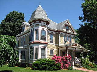
The Day Estate Historic District encompasses part of a subdivided estate at the corner of Commonwealth Avenue and Dartmouth Street in Newton, Massachusetts, United States. The district is bounded by Commonwealth, Dartmouth, Chestnut, and Prince Streets, and includes six houses located on Commonwealth and Dartmouth. It was originally owned by Henry Day, a banker, who in 1896 built the house at 321 Chestnut Street. The block was subdivided during a building boom in the 1920s, and the new houses were built between 1928 and 1930. All six houses are high quality Tudor Revival structures, five of them designed by William J. Freethey. Day's estate house is now home to the All Newton Music School, and the rest of the northeastern portion of the estate has more modern construction. The district was listed on the National Register of Historic Places in 1990.

The Front Street Historic District in Exeter, New Hampshire, encompasses a portion of the town's historic center. The district extends from Swasey Pavilion, at the junction of Front and Water streets, southwesterly along Front Street to Gale Park, about five blocks. Front Street is one of Exeter's oldest roads, and is lined with a series of 18th and 19th-century civic, religious, and residential structures, many of which are well preserved. The district was listed on the National Register of Historic Places (NRHP) in 1973.
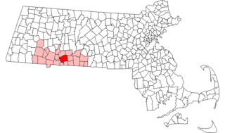
This is a list of the National Register of Historic Places listings in Springfield, Massachusetts.


