
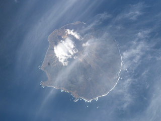
Atlasov Island, known in Russian as Ostrov Atlasova (Остров Атласова), or in Japanese as Araido (阿頼度島), is the northernmost island and volcano and also the highest volcano of the Kuril islands, part of the Sakhalin Oblast in Russia. The Russian name is sometimes rendered in English as Atlasova Island. Other names for the island include Uyakhuzhach, Oyakoba and Alaid, the name of the volcano on the island.

Kiska is an island in the Rat Islands group of the Aleutian Islands of Alaska. It is about 22 miles (35 km) long and varies in width from 1.5 to 6 miles. It is part of Aleutian Islands Wilderness and as such, special permissions are required to visit it. The island has no permanent population.

Zavodovski Island is an uninhabited volcanic island in the Traversay Islands subgroup of the South Sandwich Islands. It lies 350 kilometres (217 mi) southeast of South Georgia Island. It is the northernmost of the South Sandwich Islands and the nearest to South Georgia.

Kunashir Island, possibly meaning Black Island or Grass Island in Ainu, is the southernmost island of the Kuril Islands, an archipelago under Russian control, among which Kunashir Island and another three islands are claimed by Japan.

The Makushin Volcano is an ice-covered stratovolcano located on Unalaska Island in the Aleutian Islands of the U.S. state of Alaska. With an elevation of 2,036 meters (6,680 ft), its summit is the highest point on the island. Makushin is one of the most active among the 52 historically active volcanoes of Alaska. It has erupted at least two dozen times over the past several thousand years, with the last eruption occurring in 1995.

Kamchatka Krai is a federal subject of Russia. It is geographically located in the Far East region of the country, and it is administratively part of the Far Eastern Federal District. Kamchatka Krai has a population of 322,079 (2010).
Ketoy is an uninhabited volcanic island located in the centre of the Kuril Islands chain in the Sea of Okhotsk in the northwest Pacific Ocean. Its name is derived from the Ainu language for "skeleton" or "bad".

Kharimkotan ; Japanese 春牟古丹島; Harimukotan-tō, alternatively Harumukotan-tō or 加林古丹島; Karinkotan-tō) is an uninhabited volcanic island located 13 km (8 mi) from Onekotan near the northern end of the Kuril Islands chain in the Sea of Okhotsk in the northwest Pacific Ocean. Its name is derived from the Ainu language, from “village of many Cardiocrinum”.

A complex volcano, also called a compound volcano, is mixed landform consisting of related volcanic centers and their associated lava flows and pyroclastic rock. They may form due to changes in eruptive habit or in the location of the principal vent area on a particular volcano. Stratovolcanoes can also form a large caldera that gets filled in by a lava dome, or else multiple small cinder cones, lava domes and craters may develop on the caldera's rim.

Ebeko is a highly active somma volcano located on the northern end of Paramushir Island, Kuril Islands, Russia. It is one of the most active volcanoes of the Kuril Islands.

Rudakov is a stratovolcano located in the central part of Urup Island, Kuril Islands, Russia. The volcano has a 700 metres (2,300 ft) wide crater which contains a 300 m (1,000 ft) wide crater lake.
Kolokol Group is a group of somma volcanoes located in the central part of Urup Island, Kuril Islands, Russia. The group is named after its highest volcano but also includes volcanoes called Berg, Trezubetz and Borzov. The most active in the group is Berg, while Borzov is the oldest.

Bogatyr Ridge is a stratovolcano located in the central part of Iturup Island, Kuril Islands, Russia. The highest peak of the ridge is Stokap which is also the highest peak of the island.

Tyatya is a volcano located in the northeastern part of Kunashir Island, Kuril Islands, Russia. It is the highest peak on the island with an elevation of 1,819 metres (5,968 ft). Tyatya is one of the finest examples anywhere in the world of a somma volcano, a stratovolcano whose summit has collapsed to form a caldera which has then been mostly refilled by a new, younger volcanic cone which rises above the caldera rim.
Brouton Bay is a bay formed within the volcanic caldera of Urataman volcano at the northern end of Simushir Island in the Kuril Islands, Russia.
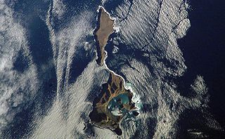
Ushishir is an uninhabited volcanic island located in the centre of the Kuril Islands chain in the Sea of Okhotsk in the northwest Pacific Ocean. Its name is derived from the Ainu language for "hot spring".
The Karpinsky Group is a volcanic group located at the southern end of Paramushir Island, Kuril Islands, Russia. The group is capped by two gently sloping cones rising to a height of 1345 m. They are composed of andesites and andesite-basalts. In the two craters there are fumaroles and fountains of liquid sulfur. The last major, and only historic, eruption was in 1952. The sides of the volcanoes have been heavily glaciated leaving a number of cirques which were initially thought to be eroded craters. The volcanoes were named after the geologist Aleksandr Petrovich Karpinsky.


