Gorodishchensky District is an administrative district (raion), one of the thirty-three in Volgograd Oblast, Russia. As a municipal division, it is incorporated as Gorodishchensky Municipal District. It is located in the southern central part of the oblast. The area of the district is 2,450 square kilometers (950 sq mi). Its administrative center is the urban locality of Gorodishche. Population: 60,188 (2010 Census); 57,308 ; 45,982 (1989 Census). The population of Gorodishche accounts for 35.5% of the district's total population.

Oktyabrsky District is an administrative district (raion), one of the thirty-three in Volgograd Oblast, Russia. As a municipal division, it is incorporated as Oktyabrsky Municipal District. It is located in the south of the oblast. The area of the district is 3,740 square kilometers (1,440 sq mi). Its administrative center is the urban locality of Oktyabrsky. Population: 21,760 (2010 Census); 24,348 ; 25,315 (1989 Census). The population of the administrative center accounts for 28.3% of the district's total population.

Kamyshinsky District is an administrative district (raion), one of the thirty-three in Volgograd Oblast, Russia. As a municipal division, it is incorporated as Kamyshinsky Municipal District. It is located in the northeast of the oblast. The area of the district is 3,563 square kilometers (1,376 sq mi). Its administrative center is the city of Kamyshin. Population: 42,893 (2010 Census); 45,019 ; 37,276 (1989 Census).
Surovikino is a town and the administrative center of Surovikinsky District in Volgograd Oblast, Russia, located at the confluence of the Chir and Don Rivers, 154 kilometers (96 mi) west of Volgograd, the administrative center of the oblast. Population: 20,533 (2010 Census); 20,338 (2002 Census); 18,336 (1989 Census).

Mikhaylovka is a town in Volgograd Oblast, Russia, located on the right bank of the Medveditsa River, 210 kilometers (130 mi) northwest of Volgograd. Population: 59,132 (2010 Census); 60,034 (2002 Census); 58,323 (1989 Census).

Bykovsky District is an administrative district (raion), one of the thirty-three in Volgograd Oblast, Russia. As a municipal division, it is incorporated as Bykovsky Municipal District. It is located in the east of the oblast. The area of the district is 3,410 square kilometers (1,320 sq mi). Its administrative center is the urban locality of Bykovo. Population: 27,055 (2010 Census); 28,572 ; 27,151 (1989 Census). The population of Bykovo accounts for 28.5% of the district's total population.
Dubovsky District is an administrative district (raion), one of the thirty-three in Volgograd Oblast, Russia. As a municipal division, it is incorporated as Dubovsky Municipal District. It is located in the center of the oblast. The area of the district is 3,080 square kilometers (1,190 sq mi). Its administrative center is the town of Dubovka. Population: 30,108 (2010 Census); 31,186 ; 28,024 (1989 Census). The population of Dubovka accounts for 47.7% of the district's total population.

Ilovlinsky District is an administrative district (raion), one of the thirty-three in Volgograd Oblast, Russia. As a municipal division, it is incorporated as Ilovlinsky Municipal District. It is located in the center of the oblast. The area of the district is 4,155 square kilometers (1,604 sq mi). Its administrative center is the urban locality of Ilovlya. Population: 33,168 (2010 Census); 34,358 ; 31,678 (1989 Census). The population of Ilovlya accounts for 33.9% of the district's total population.
Kikvidzensky District is an administrative district (raion), one of the thirty-three in Volgograd Oblast, Russia. Municipally, it is incorporated as Kikvidzensky Municipal District. It is located in the northwest of the oblast. The area of the district is 2,120 square kilometers (820 sq mi). Its administrative center is the rural locality of Preobrazhenskaya. Population: 17,669 (2010 Census); 18,860 ; 18,732 (1989 Census). The population of Preobrazhenskaya accounts for 31.3% of the district's total population.

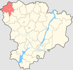
Mikhaylovsky District is an administrative district (raion), one of the thirty-three in Volgograd Oblast, Russia. As a municipal division, it is a part of Mikhaylovka Urban Okrug. It is located in the northwestern central part of the oblast. The area of the district is 3,660 square kilometers (1,410 sq mi). Its administrative center is the town of Mikhaylovka. Population: 25,936 (2010 Census); 25,978 ; 25,112 (1989 Census).

Nekhayevsky District is an administrative district (raion), one of the thirty-three in Volgograd Oblast, Russia. Municipally, it is incorporated as Nekhayevsky Municipal District. It is located in the northwest of the oblast. The area of the district is 2,220 square kilometers (860 sq mi). Its administrative center is the rural locality of Nekhayevskaya. Population: 15,588 (2010 Census); 17,660 ; 19,080 (1989 Census). The population of Nekhayevskaya accounts for 30.0% of the district's total population.

Nikolayevsky District is an administrative district (raion), one of the thirty-three in Volgograd Oblast, Russia. As a municipal division, it is incorporated as Nikolayevsky Municipal District. It is located in the northeast of the oblast. The area of the district is 3,440 square kilometers (1,330 sq mi). Its administrative center is the town of Nikolayevsk. Population: 32,034 (2010 Census); 34,285 ; 35,145 (1989 Census). The population of Nikolayevsk accounts for 47.1% of the district's total population.

Novoanninsky District is an administrative district (raion), one of the thirty-three in Volgograd Oblast, Russia. As a municipal division, it is incorporated as Novoanninsky Municipal District. It is located in the northwest of the oblast. The area of the district is 3,080 square kilometers (1,190 sq mi). Its administrative center is the town of Novoanninsky. Population: 37,306 (2010 Census); 41,611 ; 44,758 (1989 Census). The population of the administrative center accounts for 48.0% of the district's total population.

Serafimovichsky District is an administrative district (raion), one of the thirty-three in Volgograd Oblast, Russia. As a municipal division, it is incorporated as Serafimovichsky Municipal District. It is located in the west of the oblast. The area of the district is 4,360 square kilometers (1,680 sq mi). Its administrative center is the town of Serafimovich. Population: 25,378 (2010 Census); 27,137 ; 27,684 (1989 Census). The population of Serafimovich accounts for 36.9% of the district's total population.

Surovikinsky District is an administrative district (raion), one of the thirty-three in Volgograd Oblast, Russia. As a municipal division, it is incorporated as Surovikinsky Municipal District. It is located in the southwest of the oblast. The area of the district is 3,870 square kilometers (1,490 sq mi). Its administrative center is the town of Surovikino. Population: 37,104 (2010 Census); 38,956 ; 38,256 (1989 Census). The population of Surovikino accounts for 55.3% of the district's total population.

Svetloyarsky District is an administrative district (raion), one of the thirty-three in Volgograd Oblast, Russia. As a municipal division, it is incorporated as Svetloyarsky Municipal District. It is located in the southeast of the oblast. The area of the district is 3,390 square kilometers (1,310 sq mi). Its administrative center is the urban locality of Svetly Yar. Population: 38,355 (2010 Census); 39,384 ; 35,483 (1989 Census). The population of Svetly Yar accounts for 32.7% of the district's total population.

Yelansky District is an administrative district (raion), one of the thirty-three in Volgograd Oblast, Russia. As a municipal division, it is incorporated as Yelansky Municipal District. It is located in the north of the oblast. The area of the district is 2,672 square kilometers (1,032 sq mi). Its administrative center is the urban locality of Yelan. Population: 33,064 (2010 Census); 36,212 ; 36,293 (1989 Census). The population of Yelan accounts for 44.9% of the district's total population.

Oktyabrsky is an urban locality and the administrative center of Oktyabrsky District in Volgograd Oblast, Russia. Population: 6,157 (2010 Census); 6,863 (2002 Census); 6,761 (1989 Census).

Ilovlya is an urban-type settlement and the administrative center of Ilovlinsky District, Volgograd Oblast, Russia. Population: 11,255 (2010 Census); 11,904 (2002 Census); 10,295 (1989 Census).