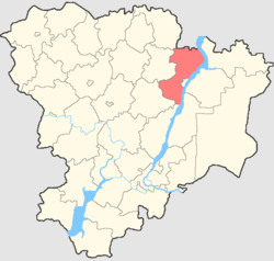
Gorodishchensky District is an administrative district (raion), one of the thirty-three in Volgograd Oblast, Russia. As a municipal division, it is incorporated as Gorodishchensky Municipal District. It is located in the southern central part of the oblast. The area of the district is 2,450 square kilometers (950 sq mi). Its administrative center is the urban locality of Gorodishche. Population: 60,188 (2010 Census); 57,308 ; 45,982 (1989 Census). The population of Gorodishche accounts for 35.5% of the district's total population.

Petrov Val is a town in Kamyshinsky District of Volgograd Oblast, Russia, located on the left bank of the Ilovlya River, 185 kilometers (115 mi) north of Volgograd, the administrative center of the oblast. Population: 13,239 (2010 Census); 14,721 (2002 Census); 13,752 (1989 Census).
Surovikino is a town and the administrative center of Surovikinsky District in Volgograd Oblast, Russia, located at the confluence of the Chir and Don Rivers, 154 kilometers (96 mi) west of Volgograd, the administrative center of the oblast. Population: 20,533 (2010 Census); 20,338 (2002 Census); 18,336 (1989 Census).

Chernyshkovsky District is an administrative district (raion), one of the thirty-three in Volgograd Oblast, Russia. As a municipal division, it is incorporated as Chernyshkovsky Municipal District. It is located in the southwest of the oblast. The area of the district is 3,079.96 square kilometers (1,189.18 sq mi). Its administrative center is the urban locality of Chernyshkovsky. Population: 16,873 (2010 Census); 18,326 ; 19,317 (1989 Census). The population of the administrative center accounts for 32.0% of the district's total population.
Dubovsky District is an administrative district (raion), one of the thirty-three in Volgograd Oblast, Russia. As a municipal division, it is incorporated as Dubovsky Municipal District. It is located in the center of the oblast. The area of the district is 3,080 square kilometers (1,190 sq mi). Its administrative center is the town of Dubovka. Population: 30,108 (2010 Census); 31,186 ; 28,024 (1989 Census). The population of Dubovka accounts for 47.7% of the district's total population.

Ilovlinsky District is an administrative district (raion), one of the thirty-three in Volgograd Oblast, Russia. As a municipal division, it is incorporated as Ilovlinsky Municipal District. It is located in the center of the oblast. The area of the district is 4,155 square kilometers (1,604 sq mi). Its administrative center is the urban locality of Ilovlya. Population: 33,168 (2010 Census); 34,358 ; 31,678 (1989 Census). The population of Ilovlya accounts for 33.9% of the district's total population.

Kotovsky District is an administrative district (raion), one of the thirty-three in Volgograd Oblast, Russia. As a municipal division, it is incorporated as Kotovsky Municipal District. It is located in the north of the oblast. The area of the district is 2,450 square kilometers (950 sq mi). Its administrative center is the town of Kotovo. Population: 34,477 (2010 Census); 38,700 ; 38,081 (1989 Census). The population of Kotovo accounts for 69.9% of the district's total population.

Mikhaylovsky District is an administrative district (raion), one of the thirty-three in Volgograd Oblast, Russia. As a municipal division, it is a part of Mikhaylovka Urban Okrug. It is located in the northwestern central part of the oblast. The area of the district is 3,660 square kilometers (1,410 sq mi). Its administrative center is the town of Mikhaylovka. Population: 25,936 (2010 Census); 25,978 ; 25,112 (1989 Census).

Nekhayevsky District is an administrative district (raion), one of the thirty-three in Volgograd Oblast, Russia. Municipally, it is incorporated as Nekhayevsky Municipal District. It is located in the northwest of the oblast. The area of the district is 2,220 square kilometers (860 sq mi). Its administrative center is the rural locality of Nekhayevskaya. Population: 15,588 (2010 Census); 17,660 ; 19,080 (1989 Census). The population of Nekhayevskaya accounts for 30.0% of the district's total population.

Nikolayevsky District is an administrative district (raion), one of the thirty-three in Volgograd Oblast, Russia. As a municipal division, it is incorporated as Nikolayevsky Municipal District. It is located in the northeast of the oblast. The area of the district is 3,440 square kilometers (1,330 sq mi). Its administrative center is the town of Nikolayevsk. Population: 32,034 (2010 Census); 34,285 ; 35,145 (1989 Census). The population of Nikolayevsk accounts for 47.1% of the district's total population.

Novoanninsky District is an administrative district (raion), one of the thirty-three in Volgograd Oblast, Russia. As a municipal division, it is incorporated as Novoanninsky Municipal District. It is located in the northwest of the oblast. The area of the district is 3,080 square kilometers (1,190 sq mi). Its administrative center is the town of Novoanninsky. Population: 37,306 (2010 Census); 41,611 ; 44,758 (1989 Census). The population of the administrative center accounts for 48.0% of the district's total population.

Olkhovsky District is an administrative [district (raion), one of the thirty-three in Volgograd Oblast, Russia. Municipally, it is incorporated as Olkhovsky Municipal District. It is located in the center of the oblast. The area of the district is 3,300 square kilometers (1,300 sq mi). Its administrative center is the rural locality of Olkhovka. Population: 17,626 (2010 Census); 19,178 ; 18,356 (1989 Census). The population of Olkhovka accounts for 30.6% of the district's total population.

Serafimovichsky District is an administrative district (raion), one of the thirty-three in Volgograd Oblast, Russia. As a municipal division, it is incorporated as Serafimovichsky Municipal District. It is located in the west of the oblast. The area of the district is 4,360 square kilometers (1,680 sq mi). Its administrative center is the town of Serafimovich. Population: 25,378 (2010 Census); 27,137 ; 27,684 (1989 Census). The population of Serafimovich accounts for 36.9% of the district's total population.

Surovikinsky District is an administrative district (raion), one of the thirty-three in Volgograd Oblast, Russia. As a municipal division, it is incorporated as Surovikinsky Municipal District. It is located in the southwest of the oblast. The area of the district is 3,870 square kilometers (1,490 sq mi). Its administrative center is the town of Surovikino. Population: 37,104 (2010 Census); 38,956 ; 38,256 (1989 Census). The population of Surovikino accounts for 55.3% of the district's total population.

Svetloyarsky District is an administrative district (raion), one of the thirty-three in Volgograd Oblast, Russia. As a municipal division, it is incorporated as Svetloyarsky Municipal District. It is located in the southeast of the oblast. The area of the district is 3,390 square kilometers (1,310 sq mi). Its administrative center is the urban locality of Svetly Yar. Population: 38,355 (2010 Census); 39,384 ; 35,483 (1989 Census). The population of Svetly Yar accounts for 32.7% of the district's total population.

Zhirnovsky District is an administrative district (raion), one of the thirty-three in Volgograd Oblast, Russia. As a municipal division, it is incorporated as Zhirnovsky Municipal District. It is located in the north of the oblast. The area of the district is 2,970 square kilometers (1,150 sq mi). Its administrative center is the town of Zhirnovsk. Population: 43,685 (2010 Census); 47,575 ; 46,418 (1989 Census). The population of Zhirnovsk accounts for 38.6% of the district's total population.

Novonikolayevsky District is an administrative district (raion), one of the thirty-three in Volgograd Oblast, Russia. As a municipal division, it is incorporated as Novonikolayevsky Municipal District. It is located in the northwest of the oblast. The area of the district is 2,362 square kilometers (912 sq mi). Its administrative center is the urban locality of Novonikolayevsky. Population: 22,618 (2010 Census); 25,511 ; 27,826 (1989 Census). The population of the administrative center accounts for 43.9% of the district's total population.

Oktyabrsky is an urban locality and the administrative center of Oktyabrsky District in Volgograd Oblast, Russia. Population: 6,157 (2010 Census); 6,863 (2002 Census); 6,761 (1989 Census).
Ilovlya is an urban-type settlement and the administrative center of Ilovlinsky District, Volgograd Oblast, Russia. Population: 11,255 (2010 Census); 11,904 (2002 Census); 10,295 (1989 Census).