You can help expand this article with text translated from the corresponding article in French. (August 2020)Click [show] for important translation instructions.
|
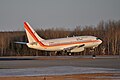
Val-d'Or Airport | |||||||||||
|---|---|---|---|---|---|---|---|---|---|---|---|
 | |||||||||||
| Summary | |||||||||||
| Airport type | Public | ||||||||||
| Operator | Aéroport régional de Val-d'Or | ||||||||||
| Location | Val-d'Or, Quebec | ||||||||||
| Time zone | EST (UTC−05:00) | ||||||||||
| • Summer (DST) | EDT (UTC−04:00) | ||||||||||
| Elevation AMSL | 1,105 ft / 337 m | ||||||||||
| Coordinates | 48°03′12″N077°46′58″W / 48.05333°N 77.78278°W | ||||||||||
| Website | www.arvo.qc.ca | ||||||||||
| Map | |||||||||||
 CYVO  CYVO | |||||||||||
| Runways | |||||||||||
| |||||||||||
| Statistics (2012) | |||||||||||
| |||||||||||
Val-d'Or Airport( IATA : YVO, ICAO : CYVO) is located 2.5 nautical miles (4.6 km; 2.9 mi) south of Val-d'Or, Quebec, Canada.