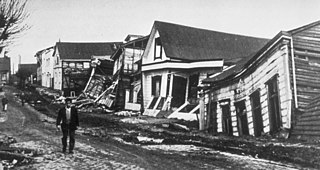
The 1960 Valdivia earthquake and tsunami or the Great Chilean earthquake on 22 May 1960 was the most powerful earthquake ever recorded. Most studies have placed it at 9.4–9.6 on the moment magnitude scale, while some studies have placed the magnitude lower than 9.4. It occurred in the afternoon, and lasted 10 minutes. The resulting tsunamis affected southern Chile, Hawaii, Japan, the Philippines, eastern New Zealand, southeast Australia, and the Aleutian Islands.

The South American plate is a major tectonic plate which includes the continent of South America as well as a sizable region of the Atlantic Ocean seabed extending eastward to the African plate, with which it forms the southern part of the Mid-Atlantic Ridge.
The Peru–Chile Trench, also known as the Atacama Trench, is an oceanic trench in the eastern Pacific Ocean, about 160 kilometres (99 mi) off the coast of Peru and Chile. It reaches a maximum depth of 8,065 m (26,460 ft) below sea level in Richards Deep and is approximately 5,900 km (3,666 mi) long; its mean width is 64 km (40 mi) and it covers an expanse of some 590,000 km2 (230,000 sq mi).
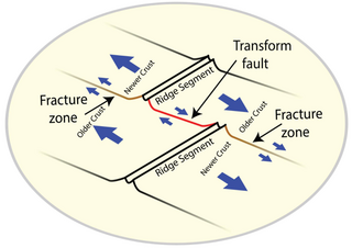
A fracture zone is a linear feature on the ocean floor—often hundreds, even thousands of kilometers long—resulting from the action of offset mid-ocean ridge axis segments. They are a consequence of plate tectonics. Lithospheric plates on either side of an active transform fault move in opposite directions; here, strike-slip activity occurs. Fracture zones extend past the transform faults, away from the ridge axis; are usually seismically inactive, although they can display evidence of transform fault activity, primarily in the different ages of the crust on opposite sides of the zone.

Villarrica is one of Chile's most active volcanoes, rising above the lake and town of the same name, 750 km (470 mi) south of Santiago. It is also known as Rucapillán, a Mapuche word meaning "great spirit's house" or " the demon's house". It is the westernmost of three large stratovolcanoes that trend northwest to southeast obliquely perpendicular to the Andean chain along the Mocha-Villarrica Fault Zone, and along with Quetrupillán and the Chilean portion of Lanín, are protected within Villarrica National Park. Guided ascents are popular during summer months.

The Los Ríos Region is one of Chile's 16 regions, the country's first-order administrative divisions. Its capital is Valdivia. It began to operate as a region on October 2, 2007, having been created by subdividing the Los Lagos Region in southern Chile. It consists of two provinces: Valdivia and the newly created Ranco Province, which was formerly part of Valdivia Province.

Valdivia Province is one of two provinces of the southern Chilean region of Los Ríos (XIV). The provincial capital is Valdivia. Located in the province are two important rivers, the Calle-Calle / Valdivia River and the Cruces River. It is part of Northern Patagonia and its wild virgin forest embrace the Patagonian Cordillera following the river Calle Calle down to the Pacific Ocean. It is known in Patagonia by the term "Bosque Valdiviano", referring to the primitive forest of Valdivia with its native trees. These forests are present in some parts of Northern Patagonia, both in Chile and Argentina.

Valdivia is a city and commune in southern Chile, administered by the Municipality of Valdivia. The city is named after its founder, Pedro de Valdivia, and is located at the confluence of the Calle-Calle, Valdivia, and Cau-Cau Rivers, approximately 15 km (9 mi) east of the coastal towns of Corral and Niebla. Since October 2007, Valdivia has been the capital of Los Ríos Region and is also the capital of Valdivia Province. The national census of 2017 recorded the commune of Valdivia as having 166,080 inhabitants (Valdivianos), of whom 150,048 were living in the city. The main economic activities of Valdivia include tourism, wood pulp manufacturing, forestry, metallurgy, and beer production. The city is also the home of the Austral University of Chile, founded in 1954 and the Centro de Estudios Científicos.

Zona Sur is one of the five natural regions on which CORFO divided continental Chile in 1950. Its northern border is formed by the Bío-Bío River, which separates it from the Central Chile Zone. The Southern Zone borders the Pacific Ocean to the west, and to the east lies the Andean mountains and Argentina. Its southern border is the Chacao Channel, which forms the boundary with the Austral Zone. While the Chiloé Archipelago belongs geographically to the Austral Zone in terms of culture and history, it lies closer to the Southern Zone.
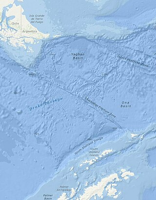
The Shackleton Fracture Zone (SFZ) is an undersea fracture zone, mid-oceanic ridge and fault located in the Drake Passage, at the separation between the Scotia plate from the Antarctic plate. It extends between 59° and 60°40' south latitude and between 56°30' and 61° west longitude and runs in a northwest to southeast direction from the South American continental shelf to the South Shetland Islands. Chile claims the area as part of its Outer Continental Shelf boundary.

The Conquest of Chile is a period in Chilean historiography that starts with the arrival of Pedro de Valdivia to Chile in 1541 and ends with the death of Martín García Óñez de Loyola in the Battle of Curalaba in 1598, and the subsequent destruction of the Seven Cities in 1598–1604 in the Araucanía region.
The Easter Fracture Zone is an oceanic fracture zone associated with the transform fault extending from the Tuamotu archipelago in the west to the Peru–Chile Trench to the east.
The 1995 Antofagasta earthquake occurred on July 30 at 05:11 UTC with a moment magnitude of 8.0 and a maximum Mercalli intensity of VII. The Antofagasta Region in Chile was affected by a moderate tsunami, with three people killed, 58 or 59 injured, and around 600 homeless. Total damage from the earthquake and tsunami amounted to $1.791 million.
Mocha Fracture Zone (MFZ) is a fracture zone on the Nazca Plate off the coast of Mocha Island, Chile. Mocha Fracture Zone trends from the Valdivia Fracture Zone in the south to the Peru–Chile Trench axis 100 km west of Mocha Island.
The Chile Fracture Zone (CFZ) is a major strike slip fault and fracture zone in the Chile Rise. The Chile Fracture Zone runs in an eastwest direction almost parallel to nearby Juan Fernández Ridge and makes up a large part of the Antarctic—Nazca plate boundary. It was discovered by HMS Challenger
The 1837 Valdivia earthquake struck south-central Chile on November 7. Together with earthquakes in 1575 and 1737 the earthquake is among the historical predecessors to the great 1960 earthquake. The rupture zone was roughly from Valdivia to the south. It was felt in the cities of Concepción, Valdivia and Ancud. The earthquake was also felt by the crew whaling ships in Guafo Island and Chonos Archipelago. Various landslides were triggered in Chiloé and people are reported to have been thrown to the ground in Valdivia. In contrast in Concepción the shakings were moderate. As reported in various coastal localities the ground rose as result of the earthquake. Decades later while surveying southern Chile's coasts Francisco Vidal Gormaz was told of islands that been submerged and some that had emerged as a consequence of the earthquake. The earthquake caused a tsunami that struck Hawaii, what is now French Polynesia, and Japan. At Hilo, Hawaii, the tsunami destroyed 66 houses and caused the deaths of 14 inhabitants.
The Mocha-Villarrica Fault Zone is a northwest-trending geological fault zone in southern Chile and Argentina. The fault zone runs from Mocha Island in the Pacific to the Andes where it aligns Villarrica, Quetrupillán and Lanín volcanoes. It is one of several fault zones that traverses the north-south Liquiñe-Ofqui Fault.

The Chile Ridge, also known as the Chile Rise, is a submarine oceanic ridge formed by the divergent plate boundary between the Nazca plate and the Antarctic plate. It extends from the triple junction of the Nazca, Pacific, and Antarctic plates to the Southern coast of Chile. The Chile Ridge is easy to recognize on the map, as the ridge is divided into several segmented fracture zones which are perpendicular to the ridge segments, showing an orthogonal shape toward the spreading direction. The total length of the ridge segments is about 550–600 km.
