| Vermilion River | |
|---|---|
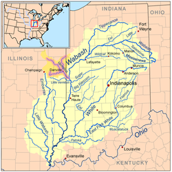 Map of the Vermilion River (including the Salt, Middle, and North forks) highlighted within the Wabash River watershed. | |
 Vermilion River watershed (Interactive map) | |
| Location | |
| Country | United States |
| Physical characteristics | |
| Source | |
| • location | Confluence of the Middle Fork and Salt Fork west of Danville, Illinois |
| • coordinates | 40°06′13″N87°43′01″W / 40.1036474°N 87.716968°W |
| Mouth | |
• location | Wabash River northeast of Cayuga, Indiana |
• coordinates | 39°57′31″N87°26′24″W / 39.9586493°N 87.4400157°W |
• elevation | 472 ft (144 m) |
| Length | 28.4 miles (45.7 km) [1] |
| Discharge | |
| • location | Danville, Illinois |
| • average | 1,078 cu/ft. per sec. [2] |
| Basin features | |
| Progression | Vermilion River → Wabash → Ohio → Mississippi → Gulf of Mexico |
| Tributaries | |
| • left | Middle Fork, North Fork |
| • right | Salt Fork |
| GNIS ID | 445248 |
The Vermilion River is a tributary of the Wabash River in the states of Illinois and Indiana, United States. [3]
Contents
There are two "Vermilion Rivers" in Illinois. The Wabash tributary flows south, while the other Vermilion River flows north to the Illinois River. There are also two Little Vermilion rivers, one flowing into the Wabash River and one into the Illinois.
The north-flowing Vermilion River and the south-flowing Middle Fork Vermilion River lie along a straight line connecting Oglesby and Danville. The two rivers drain what was once an upland marsh near Roberts. The two rivers have been extended by drainage ditches so that they nearly connect at their headwaters. The rivers may share a common name because early settlers regarded them as a single river that flowed in two directions. The rivers may have served as a canoe route between the Illinois River and Wabash River, with a portage through the marshes near Roberts.