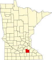
Walcott Township, Rice County, Minnesota

Last updated

Walcott Township, Minnesota
USA Minnesota location map.svg
Red pog.svg
Walcott Township, Minnesota
Location within the state of Minnesota
Usa edcp location map.svg
Red pog.svg
Walcott Township, Minnesota
Walcott Township, Minnesota (the United States)
Coordinates: 44°13′55″N93°14′31″W / 44.23194°N 93.24194°W / 44.23194; -93.24194
Country United States
State Minnesota
County Rice
Area
  Total33.7 sq mi (87.3 km2)
  Land33.7 sq mi (87.2 km2)
  Water0.0 sq mi (0.1 km2)
Elevation
1,194 ft (364 m)
Population
 (2000)
  Total984
  Density29.2/sq mi (11.3/km2)
Time zone UTC-6 (Central (CST))
  Summer (DST) UTC-5 (CDT)
FIPS code 27-67666 [1]
GNIS feature ID0665896 [2]

Walcott Township is a township in Rice County, Minnesota, United States. The population was 984 at the 2000 census. The unincorporated communities of Prairieville and Ruskin are both partially located within the township.

Contents

Settled in the 1850s, Walcott Township was named for Samuel Walcott, an early settler. [3]

Geography

According to the United States Census Bureau, the township has a total area of 33.7 square miles (87.3 km2), of which 33.7 square miles (87.2 km2) is land and 0.04 square mile (0.1 km2) (0.06%) is water. The Straight River flows northwardly through the township. [4]

Demographics

As of the census [1] of 2000, there were 984 people, 334 households, and 276 families residing in the township. The population density was 29.2 inhabitants per square mile (11.3/km2). There were 343 housing units at an average density of 10.2/sq mi (3.9/km2). The racial makeup of the township was 98.78% White, 0.10% Native American, 0.61% Asian, 0.30% from other races, and 0.20% from two or more races. Hispanic or Latino of any race were 0.51% of the population.

There were 334 households, out of which 42.2% had children under the age of 18 living with them, 75.4% were married couples living together, 3.3% had a female householder with no husband present, and 17.1% were non-families. 14.1% of all households were made up of individuals, and 5.7% had someone living alone who was 65 years of age or older. The average household size was 2.92 and the average family size was 3.25.

In the township the population was spread out, with 29.3% under the age of 18, 6.9% from 18 to 24, 27.3% from 25 to 44, 24.8% from 45 to 64, and 11.7% who were 65 years of age or older. The median age was 38 years. For every 100 females, there were 106.3 males. For every 100 females age 18 and over, there were 111.6 males.

The median income for a household in the township was $58,594, and the median income for a family was $63,036. Males had a median income of $38,482 versus $25,556 for females. The per capita income for the township was $20,274. About 1.4% of families and 4.0% of the population were below the poverty line, including 3.9% of those under age 18 and 7.3% of those age 65 or over.

Related Research Articles

Morrison Township is a township in Aitkin County, Minnesota, United States. The population was 200 as of the 2010 census.

Hiram Township is a township in Cass County, Minnesota, United States. The population was 334 as of the 2000 census. Hiram Township was named for Hiram Wilson, a pioneer settler.

Flowing Township is a township in Clay County, Minnesota, United States. The population was 97 at the 2000 census.

Goodland Township is a township in Itasca County, Minnesota, United States. The population was 466 at the 2010 census.

Lawrence Township is a township in Itasca County, Minnesota, United States. The population was 438 at the 2010 census.

Wildwood Township is a township in Itasca County, Minnesota, United States. The population was 193 at the 2010 census.

Hantho Township is a township in Lac qui Parle County, Minnesota, United States. The population was 154 at the 2000 census.

Silver Creek Township is a township in Lake County, Minnesota, United States. The population was 1,178 at the 2000 census.

East Park Township is a township in Marshall County, Minnesota, United States. The population was 19 at the 2000 census.

Fork Township is a township in Marshall County, Minnesota, United States. The population was 14 at the 2000 census.

Veldt Township is a township in Marshall County, Minnesota, United States. The population was 56 at the 2000 census.

Jay Township is a township in Martin County, Minnesota, United States. The population was 269 at the 2000 census.

Elmdale Township is a township in Morrison County, Minnesota, United States. The population was 904 at the 2000 census.

Wild Rice Township is a township in Norman County, Minnesota, United States. The population was 334 at the 2000 census.

Kalmar Township is a township in Olmsted County, Minnesota, United States. The population was 1,196 at the 2000 census. It surrounds the city of Byron.

Bluffton Township is a township in Otter Tail County, Minnesota, United States. The population was 474 at the 2000 census.

Edna Township is a township in Otter Tail County, Minnesota, United States. The population was 921 at the 2000 census.

Crosby Township is a township in Pine County, Minnesota, United States. The population was 97 at the 2000 census.

<span class="mw-page-title-main">Charlestown Township, Redwood County, Minnesota</span> Township in Minnesota, United States

Charlestown Township is one of the twenty-six townships of Redwood County, Minnesota, United States. The population was 217 at the 2000 census.

Fortier Township is a township in Yellow Medicine County, Minnesota, United States. The population was 116 at the 2000 census.

References

  1. 1 2 "U.S. Census website". United States Census Bureau . Retrieved January 31, 2008.
  2. "US Board on Geographic Names". United States Geological Survey. October 25, 2007. Retrieved January 31, 2008.
  3. Upham, Warren (1920). Minnesota Geographic Names: Their Origin and Historic Significance. Minnesota Historical Society. p.  464.
  4. Minnesota Atlas & Gazetteer. Yarmouth, Me.: DeLorme. 1994. p. 33. ISBN   0-89933-222-6.