Morristown, Minnesota

Last updated

Morristown
Nickname: 
Heaven On Earth
Motto: 
Best Town By A Dam Site
Rice County Minnesota Incorporated and Unincorporated areas Morristown Highlighted.svg
Location of Morristown, Minnesota
Coordinates: 44°13′27″N93°26′42″W / 44.22417°N 93.44500°W / 44.22417; -93.44500
CountryUnited States
State Minnesota
County Rice
Founded1855
Incorporated 1874
Government
   Mayor Tony Lindahl
Area
[1]
  Total1.14 sq mi (2.96 km2)
  Land1.14 sq mi (2.95 km2)
  Water0.00 sq mi (0.00 km2)
Elevation
[2]
1,004 ft (306 m)
Population
 (2020) [3]
  Total949
  Estimate 
(2022) [4]
1,008
  Density832.46/sq mi (321.46/km2)
Time zone UTC–6 (Central (CST))
  Summer (DST) UTC–5 (CDT)
ZIP code
55052
Area code 507
FIPS code 27-44296
GNIS feature ID2395412 [2]
Sales tax 7.375% [5]
Website ci.morristown.mn.us

Morristown is a city in Rice County, Minnesota, United States. The population was 949 at the 2020 census. [3]

Contents

History

Morristown was platted in 1855, and named for Walter Morris, a pioneer settler. [6]

Geography

According to the United States Census Bureau, the city has a total area of 1.03 square miles (2.67 km2); 1.02 square miles (2.64 km2) is land and 0.01 square miles (0.03 km2) is water. [7]

Nearly the entirety of Morristown lies on the southern bank of the Cannon River.

Minnesota State Highway 60 serves as a main route in the community.

Demographics

Historical population
CensusPop.Note
1870 317
1880 51763.1%
1890 5170.0%
1900 58913.9%
1910 5920.5%
1920 68816.2%
1930 613−10.9%
1940 67710.4%
1950 533−21.3%
1960 61615.6%
1970 6597.0%
1980 639−3.0%
1990 78422.7%
2000 98125.1%
2010 9870.6%
2020 949−3.9%
2022 (est.)1,008 [4] 6.2%
U.S. Decennial Census [8]
2020 Census [3]

2010 census

As of the census of 2010, there were 987 people, 388 households, and 255 families living in the city. The population density was 967.6 inhabitants per square mile (373.6/km2). There were 424 housing units at an average density of 415.7 per square mile (160.5/km2). The racial makeup of the city was 96.3% White, 0.6% African American, 0.2% Asian, 0.9% from other races, and 2.0% from two or more races. Hispanic or Latino of any race were 3.6% of the population.

There were 388 households, of which 33.2% had children under the age of 18 living with them, 48.7% were married couples living together, 10.6% had a female householder with no husband present, 6.4% had a male householder with no wife present, and 34.3% were non-families. 26.8% of all households were made up of individuals, and 13.1% had someone living alone who was 65 years of age or older. The average household size was 2.49 and the average family size was 3.03.

The median age in the city was 37.8 years. 25.9% of residents were under the age of 18; 7.3% were between the ages of 18 and 24; 27.4% were from 25 to 44; 24.2% were from 45 to 64; and 15.4% were 65 years of age or older. The gender makeup of the city was 50.3% male and 49.7% female.

2000 census

As of the census of 2000, there were 981 people, 363 households, and 258 families living in the city. The population density was 1,130.4 inhabitants per square mile (436.4/km2). There were 374 housing units at an average density of 431.0 per square mile (166.4/km2). The racial makeup of the city was 97.86% White, 0.10% African American, 0.51% Native American, 0.51% from other races, and 1.02% from two or more races. Hispanic or Latino of any race were 8.15% of the population.

There were 363 households, out of which 37.2% had children under the age of 18 living with them, 55.4% were married couples living together, 11.8% had a female householder with no husband present, and 28.9% were non-families. 24.8% of all households were made up of individuals, and 11.6% had someone living alone who was 65 years of age or older. The average household size was 2.65 and the average family size was 3.17.

In the city, the population was spread out, with 29.4% under the age of 18, 7.4% from 18 to 24, 32.2% from 25 to 44, 17.3% from 45 to 64, and 13.7% who were 65 years of age or older. The median age was 34 years. For every 100 females, there were 97.4 males. For every 100 females age 18 and over, there were 95.2 males.

The median income for a household in the city was $36,538, and the median income for a family was $41,382. Males had a median income of $29,375 versus $24,808 for females. The per capita income for the city was $15,762. About 7.7% of families and 10.8% of the population were below the poverty line, including 13.9% of those under age 18 and 10.7% of those age 65 or over.

Education

Waterville-Elysian-Morristown School District operates public schools. [9]

Notable people

Related Research Articles

<span class="mw-page-title-main">Le Sueur County, Minnesota</span> County in Minnesota, United States

Le Sueur County is a county located in the south central portion of the U.S. state of Minnesota. As of the 2020 census, the population was 28,674. Its county seat is Le Center.

<span class="mw-page-title-main">Waterville, Iowa</span> City in Iowa, United States

Waterville is a city in Paint Creek Township, Allamakee County, Iowa, United States. The population was 109 at the time of the 2020 census.

<span class="mw-page-title-main">Waterville, Kansas</span> City in Marshall County, Kansas

Waterville is a city in Marshall County, Kansas, United States. As of the 2020 census, the population of the city was 658.

<span class="mw-page-title-main">Backus, Minnesota</span> City in Minnesota, United States

Backus is a city in Cass County, Minnesota, United States. The population was 250 at the 2010 census. It is part of the Brainerd Micropolitan Statistical Area.

<span class="mw-page-title-main">Chickamaw Beach, Minnesota</span> City in Minnesota, United States

Chickamaw Beach is a city in Cass County, Minnesota, United States. The population was 114 at the 2010 census. It is part of the Brainerd Micropolitan Statistical Area.

<span class="mw-page-title-main">Lake Shore, Minnesota</span> City in Minnesota, United States

Lake Shore is a city in Cass County, Minnesota, United States. The population was 1,056 at the 2020 census. It is part of the Brainerd Micropolitan Statistical Area.

Elysian Township is a township in Le Sueur County, Minnesota, United States. The population was 985 at the 2000 census.

<span class="mw-page-title-main">Waterville, Minnesota</span> City in Minnesota, United States

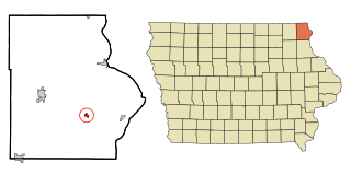
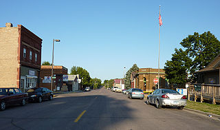
Waterville is a town in Le Sueur County, Minnesota, United States. The population was 1,868 at the 2010 census. It is close to Sakatah Lake State Park on the Cannon River.

Waterville Township is a township in Le Sueur County, Minnesota, United States. The population was 742 at the 2000 census.

<span class="mw-page-title-main">Deer Creek, Minnesota</span> City in Minnesota, United States

Deer Creek is a city in Otter Tail County, Minnesota, United States. The population was 330 at the 2020 census.

<span class="mw-page-title-main">Erhard, Minnesota</span> City in Minnesota, United States

Erhard is a city in Otter Tail County, Minnesota, United States. The population was 132 at the 2020 census.

<span class="mw-page-title-main">Henning, Minnesota</span> City in Minnesota, United States

Henning is a city in Otter Tail County, Minnesota, United States. The population was 854 at the 2020 census.

<span class="mw-page-title-main">Maplewood, Minnesota</span> City in Minnesota, United States

Maplewood is a city in Ramsey County, Minnesota, United States. The population was 42,088 at the 2020 census. Maplewood is ten minutes' drive from downtown Saint Paul. It stretches along the northern and eastern borders of Saint Paul.

Morristown Township is a township in Rice County, Minnesota, United States. The population was 665 at the 2000 census.

<span class="mw-page-title-main">Fifty Lakes, Minnesota</span> City in Minnesota, United States

Fifty Lakes is a city in Crow Wing County, Minnesota, United States. The population was 387 at the 2010 census. It is part of the Brainerd Micropolitan Statistical Area.

<span class="mw-page-title-main">Morristown, Ohio</span> Village in Ohio, United States

Morristown is a village in Belmont County, Ohio, United States. The population was 248 at the 2020 census. It is part of the Wheeling metropolitan area.

<span class="mw-page-title-main">Waterville, Ohio</span> City in Ohio, United States

Waterville is a city in Lucas County, Ohio, United States, along the Maumee River. A suburb of Toledo, the population was 6,003 at the 2020 census.

<span class="mw-page-title-main">Waterville, Washington</span> Town in Washington, United States

Waterville is a town in and the county seat of Douglas County, Washington, United States which is known for its wheat industry. As a part of Douglas County, it is part of the Wenatchee-East Wenatchee metropolitan area. The population was 1,134 at the 2020 census.

<span class="mw-page-title-main">Minnesota Lake, Minnesota</span> City in Minnesota, United States

Minnesota Lake is a city in Blue Earth and Faribault counties in the State of Minnesota. The population was 661 at the 2020 census. The bulk of the city is in Faribault County; a small part extends into Blue Earth County.

<span class="mw-page-title-main">Elysian, Minnesota</span> City in Minnesota, United States

Elysian is a city in Le Sueur and Waseca counties in the U.S. state of Minnesota. The population was 708 at the 2020 Census. The city is distinct from Elysian Township.

References

  1. "2020 U.S. Gazetteer Files". United States Census Bureau. Retrieved July 24, 2022.
  2. 1 2 U.S. Geological Survey Geographic Names Information System: Morristown, Minnesota
  3. 1 2 3 "Explore Census Data". United States Census Bureau . Retrieved January 9, 2024.
  4. 1 2 "City and Town Population Totals: 2020-2022". United States Census Bureau. January 9, 2024. Retrieved January 9, 2024.
  5. "Morristown (MN) sales tax rate" . Retrieved January 9, 2024.
  6. Upham, Warren (1920). Minnesota Geographic Names: Their Origin and Historic Significance. Minnesota Historical Society. p.  462.
  7. "US Gazetteer files 2010". United States Census Bureau. Archived from the original on January 25, 2012. Retrieved November 13, 2012.
  8. United States Census Bureau. "Census of Population and Housing" . Retrieved June 4, 2015.
  9. "Public School District Attendance Areas and Educational Facility Locations Waterville-Elysian-Morristown School District." Posted on the Waterville-Elysian-Morristown School District website. Retrieved on September 5, 2018.