
Lakeville is a town in Plymouth County, Massachusetts, United States. The population was 11,523 at the 2020 census.
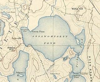
Assawompset Pond is a reservoir/pond within the towns of Lakeville and Middleboro, in southeastern Massachusetts. It shares its waters with Long Pond and is openly connected with Pocksha Pond. These lakes provide a source of drinking water to the city of New Bedford, the largest city in southeastern Massachusetts. At almost four square miles (10 km2), it is the largest natural lake in Massachusetts.

York River State Park is located near the unincorporated town of Croaker in James City County, Virginia on the south bank of the York River about 10 miles downstream from West Point.
Breakheart Reservation is a public recreation area covering 652 acres (264 ha) in the towns of Saugus and Wakefield, Massachusetts. The reservation features a hardwood forest, two freshwater lakes, a winding stretch of the Saugus River, and scenic views of Boston and rural New England from rocky hilltops. The park is managed by the Massachusetts Department of Conservation and Recreation.

The Modoc Rock Shelter is a rock shelter or overhang located beneath the sandstone bluffs that form the eastern border of the Mississippi River floodplain at which Native American peoples lived for thousands of years. This site is significant for its archaeological evidence of thousands of years of human habitation during the Archaic period in the Eastern United States. It is located on the northeastern side of County Road 7 southeast of Prairie du Rocher in Randolph County, Illinois, United States. It was declared a National Historic Landmark in 1961.

The Brooks River Archaeological District encompasses a large complex of archaeological sites along the banks of the Brooks River in Katmai National Park and Preserve in the U.S. state of Alaska. It includes at least twenty separate settlement sites with documented occupation dates from 2500 BCE to recent (post-contact) history. It was declared a National Historic Landmark in 1993. The site is partly occupied by the Brooks Camp, one of the major visitor areas of the park.

The Hardaway Site, designated by the Smithsonian trinomial 31ST4, is an archaeological site near Badin, North Carolina. A National Historic Landmark, this multi-layered site has seen major periods of occupation as far back as 10,000 years. Materials from this site were and are used to assist in dating materials from other sites in the eastern United States. The site was declared a National Historic Landmark in 1990.

The Tobias-Thompson Complex, also known as the Little River Archeological District, is a complex of archaeological sites on the banks of the Little Arkansas River near Geneseo, Kansas, United States. The complex is an important set of sites that is one of the few in the region bridging the periods of prehistory and European contact, with a period of significance between 1500 and 1700 CE. It was designated a National Historic Landmark in 1964 and listed on the National Register of Historic Places in 1966.

The Stony Brook Reservation Parkways are a group of historic parkways in Boston and Dedham, Massachusetts. They provide access to and within the Stony Brook Reservation, a Massachusetts state park. The roadways and the park are administered by the Massachusetts Department of Conservation and Recreation, a successor to the Metropolitan District Commission, which oversaw their construction. The roads consist of the Dedham, Enneking, and Turtle Pond Parkways and West Boundary Road. Two roads within the park, Smithfield Road and Reservation Road, are listed as non-contributing properties. The park roads were built between 1894 and 1956, and were listed on the National Register of Historic Places in 2006.

The Albree-Hall-Lawrence House is a historic house located at 353 Lawrence Road in Medford, Massachusetts.

The Middlesex Fells Reservoirs Historic District is a historic district roughly bounded by Pond St., Woodland Rd., I-93, and MA 28 in Stoneham and Medford, Massachusetts. It encompasses a portion of the Middlesex Fells Reservation, a state park managed by the Massachusetts Department of Conservation and Recreation (DCR). The principal features of the district are three reservoirs and their associated gate houses and pumping stations, which were developed by the Metropolitan District Commission starting in the late 19th century. The district was listed on the National Register of Historic Places in 1990.

The John Bottume House is a historic house at 4 Woodland Road in Stoneham, Massachusetts. Built c. 1849, this stone house was one of several built along the shore of Spot Pond by a Boston businessman as a retreat, and is the only one to survive. It is owned by the Massachusetts Department of Conservation and Recreation, and houses the visitors center for the Middlesex Fells Reservation. It was listed on the National Register of Historic Places in 1984.

Sargent's Pond is a man-made 3-acre (1.2 ha) pond on Sargent Road in Brookline, Massachusetts, United States. The pond was created by Charles Sprague Sargent in the late 1870s as a centerpiece of his family's extensive Holm Lea estate. Sargent's estate has since been subdivided, but the roads giving access to it run along the estate's original alignments. Sargent landscaped the estate using similar principles to those he applied at the Arboretum, with vistas and a variety of trees and shrubs. The pond was created by damming a brook. It still has naturalistic plantings around it, although some Sargent's rhododendrons have died.

West Roxbury Parkway is a historic parkway running from Washington Street in Boston, Massachusetts, where the Enneking Parkway runs south, to Horace James Circle in Chestnut Hill, where it meets the Hammond Pond Parkway. The parkway serves as a connector between Stony Brook Reservation and Hammond Pond Reservation. West Roxbury Parkway was built between 1919 and 1929 and added to the National Register of Historic Places in 2006. The parkway is distinctive in the roadway system developed by the Metropolitan District Commission beginning around the turn of the 20th century in that it was built in collaboration with the City of Boston, and is maintained by the city.

Upton State Forest is a publicly owned forest with recreational features primarily located in the town of Upton, Massachusetts, with smaller sections in the towns of Hopkinton and Westborough. The state forest encompasses nearly 2,800 acres (1,100 ha) of publicly accessible lands and includes the last remaining Civilian Conservation Corps (CCC) camp in Massachusetts, built in Rustic style. The CCC campground was listed on the National Register of Historic Places in 2014.
The Munsungan-Chase Lake Thoroughfare Archeological District encompasses a series of important archaeological sites in a remote area of northern Maine, United States. These sites offer evidence of human habitation dating to not long after the retreat of the glaciers following the Wisconsin glaciation, with extensive stone tool workshops working with red chert found in abundance in the area. Stone tools made from sources in this region have been found at archaeological sites across New England. The district was listed on the National Register of Historic Places in 1979.
The town of North Haven, Maine is an island community located principally on North Fox Island in southern Penobscot Bay, separated from its mouth by Vinalhaven. The Fox Islands were the subject of an intensive archaeological survey in the 1970s, in which more than 49 sites of interest were identified in North Haven. Eight of these were deemed significant enough to be listed on the National Register of Historic Places; the most significant of these, the Turner Farm Site, was a site exhibiting evidence of year-round occupation during at least three time periods in prehistory.
Pond Island is a small 32-acre (13 ha) island in Penobscot Bay, on the central coast of Maine, United States. The island is a conservation property of the Maine Coast Heritage Trust, and is open to the public, with two small campsites. The island was listed on the National Register of Historic Places in 1979 for the significance of its prehistoric archaeological sites. It is named for the saltwater pond located at its center.
The Jones Mill Site, designated by the Smithsonian trinomial 3HS28, is a prehistoric archaeological site near Jones Mill in Hot Spring County, Arkansas. It is a deeply stratified site, with evidence of human habitation in at least three different time periods. It is one of the few documented Archaic sites in the region, with evidence of human activity dating to 3000 BCE. It is located near documented prehistoric stone quarry sites, and finds at the site include extensive stone tool construction artifacts.

The Orwell Site, designated VT-AD-12 in the state archaeological inventory, is a mainly prehistoric archaeological site in Orwell, Vermont. The site, first investigated in 1933, is significant as one of the state's few documented examples of a heavily stratified site, with layered evidence of occupation extending back at least 2,000 years, and into colonial times. It includes a prehistoric Native American burial site with at least 46 grave sites. It was listed on the National Register of Historic Places in 1977.

