
Chicopee is a city located on the Connecticut River in Hampden County, Massachusetts, United States. At the 2020 census, the city had a population of 55,560, making it the second-largest city in western Massachusetts after Springfield. Chicopee is part of the Springfield, Massachusetts Metropolitan Statistical Area. The communities of Chicopee Center (Cabotville), Chicopee Falls, Willimansett, Fairview, Aldenville, Burnett Road, Smith Highlands and Westover are located within the city.

Easthampton is a city in Hampshire County, Massachusetts, United States. The city is in the Pioneer Valley, near the five colleges in the college towns of Northampton and Amherst. The population was 16,211 at the 2020 census.

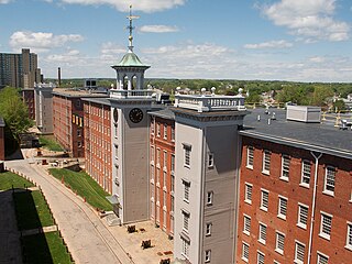
Cohoes is an incorporated city located in the northeast corner of Albany County in the U.S. state of New York. It is called the "Spindle City" because of the importance of textile manufacturing to its growth in the 19th century. The city's factories processed cotton from the Deep South.
Lowell National Historical Park is a National Historical Park of the United States located in Lowell, Massachusetts. Established in 1978 a few years after Lowell Heritage State Park, it is operated by the National Park Service and comprises a group of different sites in and around the city of Lowell related to the era of textile manufacturing in the city during the Industrial Revolution. In 2019, the park was included as Massachusetts' representative in the America the Beautiful Quarters series.

West Warwick is a town in Kent County, Rhode Island, United States. The population was 31,012 at the 2020 census.

The Augusta Canal is a historic canal located in Augusta, Georgia, United States. The canal is fed by the Savannah River and passes through three levels in suburban and urban Augusta before the water returns to the river at various locations. It was devised to harness the water power at the fall line of the Savannah River to drive mills, to provide transportation of goods, and to provide a municipal water supply. It is the only canal in the US in continuous use for its original purposes of providing power, transport, and municipal water.

Wheelockville is a village in the town (township) of Uxbridge, Massachusetts, United States. Part of the village centering on Mendon and Henry streets is listed on the National Register of Historic Places as the Wheelockville Historic District. Wheelockville appears on the Blackstone U.S. Geological Survey Map. The Village receives municipal services from Uxbridge, for fire, police, EMS, School district, public works, and other services. Worcester's Judicial District includes Uxbridge District Court. The geography of Wheelockville includes several other distinct mill villages, including: Hecla and Elmdale.

The Bemis Mill is a historic former industrial building at 1-3 Bridge Street, in the village of Nonantum, in Newton, Massachusetts. It is now a general office building called the Meredith Building. The building is significant historically as a surviving early industrial building in the city and for the remnants of unique power distribution and water control facilities that survive. On September 4, 1986, it was added to the National Register of Historic Places.

The Hope Village Historic District is a historic rural mill settlement within Hope Village in Scituate, Rhode Island. Hope Village is located on a bend in the North Pawtuxet River in the southeastern corner of Scituate. Industrial activity has occurred in Hope Village since the mid-eighteenth century. Surviving industrial and residential buildings in the Historic District date back to the early 19th century. The village center sits at junction of Main Street and North Road. Hope Village radiates out from the center with houses on several smaller side streets in a compact configuration. Currently there is little commercial or industrial activity in Hope Village and none in the Historic District. The present stone mill building on the south side of Hope Village was built in 1844 by Brown & Ives of Providence, expanded in 1871 and modified in 1910. Approximately one quarter of the village's current housing stock was built as mill worker housing by various owners of Hope Mill.

The Dorchester-Milton Lower Mills Industrial District is a historic district on both sides of the Neponset River in the Dorchester area of Boston and in the town of Milton, Massachusetts. It encompasses an industrial factory complex, most of which was historically associated with the Walter Baker & Company, the first major maker of chocolate products in the United States. The industrial buildings of the district were built between about 1868 and 1947. They were listed as part of the district on the National Register of Historic Places in 1980, with a slight enlargement in 2001. The buildings have been adapted for mixed industrial/retail/residential use.

The Bridgewater Iron Works is a historic industrial site located on High Street in Bridgewater, Massachusetts, United States, along the banks of the Town River. Previously known as Lazell, Perkins and Company, by the mid-19th century, the Bridgewater Iron Manufacturing Company was one of the largest iron works in the United States, specializing in heavy castings and forgings. The property was later acquired by the Stanley Works, with the surrounding village still known to this day as Stanley.

Mill Conversion or mill rehab is a form of adaptive reuse in which a historic mill or industrial factory building is restored or rehabilitated into another use, such as residential housing, retail shops, office, or a mix of these non-industrial elements (mixed-use).
The Albert Field Tack Company is a historic industrial site located at 19 Spring Street in Taunton, Massachusetts, next to the Mill River. Built in 1868 for a company founded in the 1820s to manufacture fasteners, the main office building is an unusually high-style building given its industrial setting. It was added to the National Register of Historic Places in 1984. It has since been converted into apartments.

The Commonwealth Avenue Historic District is a historic district on Commonwealth Avenue on the north side from Stanley Street to beyond Robinson Street in North Attleborough, Massachusetts. The area encompasses a variety of stylish 19th-century houses, as well as two 19th-century industrial buildings, depicting the proximity of wealthy industrial owners and managers to their factories. The district was added to the National Register of Historic Places in 2003.

Sachem Rock Farm is a historic farm at 355 Plymouth Street in East Bridgewater, Massachusetts, United States. The farm location is important for a variety of reasons. Its earliest historical association is with the Wampanoag people, who are known to have used the area, particularly around Sachem Rock, a granite outcrop they called Wonnocoote (Wonnocooto) that is the property's high point, prior to European contact. Sachem Rock itself is historically significant as the site of a meeting in 1649 between English settlers from the Plymouth Colony, including Myles Standish, with the Wampanoag sachem Massasoit. In this meeting the colonists purchased rights to a large tract of land, including East and West Bridgewater, Bridgewater, and Brockton.

The Mill–Prospect Street Historic District in Hatfield, Massachusetts encompasses a historic landscape with over 300 years of industrial and agricultural history. It was listed on the National Register of Historic Places in 2002. The district runs along Prospect Street, a north-south road that roughly bisects Hatfield, from its southern end at Elm Street to a point north of its junction with Chestnut Street, and includes properties on adjacent roadways. The central focus of the district is the Mill River, which meanders from west to east across the district's middle. At the Prospect Street crossing is a cluster of former late 19th century industrial buildings, some of which comprise the Old Mill Site Historic District, listed in 1982.
The Old Mill Site Historic District in Hatfield, Massachusetts encompasses the site of a late 19th century mill. It is one of only two such sites in the town. The centerpiece of the district is the former Shattuck Gun Factory building, which in 1989 housed newspaper offices and in 2006 a bed and breakfast. The district, which was listed on the National Register of Historic Places in 1982, includes three other elements: an 1891 Warren pony truss bridge across the Mill River, now closed to traffic, and a machine shop and garage, both built in 1886. The district was also included in the larger Mill-Prospect Street Historic District in 2002.

The Ipswich Mills Historic District encompasses a major textile mill complex and associated worker housing along the Ipswich River near the center of Ipswich, Massachusetts. The district includes the factories of the Ipswich Mill Company, and several blocks of modest worker cottages mostly on side streets off Estes and Kimball Streets. The site had been used as for mills since the 17th century, and was purchased by the Ipswich Mill Company in 1868. Mill worker housing was built surrounding the complex through the early 20th century, when River Court, Peatfield Street, and 1st through 6th Streets were laid out. The district was listed on the National Register of Historic Places in 1996.

The Jewell Town District of South Hampton, New Hampshire, encompasses a colonial-era industrial village with a history dating to 1687. It is centered at the junction of West Whitehall and Jewell Streets, which is just south of a bend in the Powwow River, the source of the power for the mills that were built here. The area was settled in 1687 by Thomas Jewell, and by the early 19th century included a variety of mills as well as a bog iron works. The district now includes only remnants of its industrial past, and features a collection of 18th and early-19th century residential architecture. The district was listed on the National Register of Historic Places in 1983.

Blackstone River Valley National Historical Park is a National Park Service unit in the states of Rhode Island and Massachusetts. The park was created for the purpose of preserving, protecting, and interpreting the industrial heritage of the Blackstone River Valley and the urban, rural, and agricultural landscape of that region. The Blackstone River Valley was the site of some of the earliest successful textile mills in the United States, and these mills contributed significantly to the earliest American Industrial Revolution. The subsequent construction of the Blackstone Canal, a few years after the successful completion of the Erie Canal, helped to sustain the region's industrial strength.


