
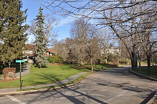
The West Newton Hill NR Historic District is a residential National Register historic district in the village of West Newton, in the city of Newton, Massachusetts in the United States. It is composed of a cohesive collection of spacious houses built in the second half of the 19th century, representing the development of the West Newton area as a fashionable railroad suburb. The district was listed on the National Register of Historic Places in 1986.
The Thomas Aspinwall Davis House is a historic house at 29 Linden Place in Brookline, Massachusetts. The house was built in 1844, by Thomas Aspinwall Davis, later a mayor of Boston, and is one of the earliest buildings to survive from his Linden Park project, the first residential subdivision in Brookline. The house was listed on the National Register of Historic Places in 1985.

Mount Pleasant Historic District is a historic district encompassing a cluster of well-preserved 19th-century residential buildings on Forest Street and Mount Pleasant Avenue in the Roxbury neighborhood of Boston, Massachusetts. First developed in 1833, it was one Roxbury's first speculative residential subdivision developments. The district features Greek Revival, Italianate, and Romanesque architecture, and was added to the National Register of Historic Places in 1989.

The Spring Hill Historic District is a historic district roughly bounded by Summer, Central, Atherton, and Spring Streets in the Spring Hill area of Somerville, Massachusetts. The district encompasses the city's best-preserved residential subdivision from the mid-19th century, with later infill construction in the late 19th and early 20th centuries. The district was listed on the National Register of Historic Places in 1989.

The Firth–Glengarry Historic District encompasses a residential area of Winchester, Massachusetts consisting of well-preserved high quality houses built mainly between 1880 and 1900. The district lies between Wildwood Street and Wedge Pond, and includes properties on Pine Street, Glengarry Road, Grassmere Avenue, Dix Street, and Wildwood Street; houses on Curtis Street and Curtis Circle, are excluded from the district. Much of the area was laid out by developer William Firth, and many of its houses were designed by Boston architect Robert Coit. The 13.44-acre (5.44 ha) district was listed on the National Register of Historic Places in 1989.

The Wedgemere Historic District encompasses the largest single 19th-century residential development of Winchester, Massachusetts. It is one of the town's largest surviving 19th-century residential subdivisions, with a concentration of high-quality residences built between about 1890 and 1920. The district was listed on the National Register of Historic Places in 1989.
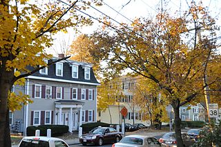
The Washington Square Historic District of Lowell, Massachusetts encompasses a historic subdivision laid out in 1832. The focal point of the subdivision is Kittridge Park, which lies on the eastern side of the district and was an original part of the subdivision plan developed by the Nesmith Brothers. It was the first significant residential subdivision in the city aimed at a wealthier clientele, and was designed by landscape architect Alexander Wadsworth. The district was added to the National Register of Historic Places in 1982, and expanded slightly in 1999.

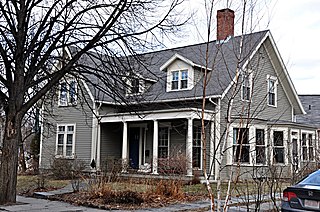
The Brae Burn Road Historic District is a residential historic district on Brae Burn and Windermere Roads in Newton, Massachusetts. It encompasses as modest residential subdivision that was laid out in the then-rural area of Auburndale in 1911. Many of its houses were designed by the regionally notable firm of Gay & Proctor, and represent a well-preserved collection of modestly scaled Craftsman and Colonial Revival style houses. The district includes 26 houses. The district was listed on the National Register of Historic Places in 1990.

The John Buckingham House is a historic house at 33–35 Waban Street in the Newton Corner village of Newton, Massachusetts. Built about 1864, it is a good local example of Second Empire architecture, typical of built at that time for upper middle class commuters to Boston. It was listed on the National Register of Historic Places in 1986.

The Commonwealth Avenue Historic District of Newton, Massachusetts, encompasses roughly the eastern half of Commonwealth Avenue, extending from Waban Hill Road, near the city line with Boston, westward to Walnut Street. The roadway was laid out in 1894 and completed in 1895. Its design was influenced in part by the local residents, who were willing to give land for some of the route, and the design of Boston portions of the road, in which Frederick Law Olmsted was involved. Construction of the roadway was followed by the construction of fashionably large residences along its route, which took place mostly between the road's construction and about 1920. The district includes 188 residential properties, which are mainly built in the revival styles popular in the early 20th century. The district was added to the National Register of Historic Places in 1990.
The Crystal Lake and Pleasant Street Historic District encompasses a streetcar suburban residential subdivision developed between 1860 and 1895 in Newton, Massachusetts. The district roughly bounded by the Sudbury Aqueduct, Pleasant Street, Lake Avenue, Webster Court, and Crystal Street. The subdivision was laid out in the 1850s after the Boston and Charles Railroad line was extended through Newton from Brookline. The district was listed on the National Register of Historic Places in 1986.

The Farlow and Kenrick Parks Historic District is a predominantly residential historic district in the Newton Corner area of Newton, Massachusetts. The district is roughly triangular in shape, and is bounded on the north by the Massachusetts Turnpike, Park Street to the east, and Franklin and Newtonville Avenues to the west. It is roughly bisected by Church Street, and is named for two parks that are significant focal elements of the district. Kenrick Park is a small lozenge-shaped park at the southern tip of the district designed by Alexander Wadsworth; it was laid out at the request of William Kenrick, a horticulturalist whose c. 1822 Federal style house was moved to the area after the park was completed. Farlow Park is a larger rectangular park, in the district's northwest, which was established by a gift from John Farlow. It is landscaped in a manner similar to the Boston Public Garden, with specimen trees and an artificial pond with bridge.
The Farlow Hill Historic District is a residential historic district in the Newton Corner area of Newton, Massachusetts, United States. It includes houses on Shornecliffe Road, Beechcroft Road, Farlow Road, Huntington Road, and a few properties on immediately adjacent streets. Most of the houses in the district were built between 1899 and the late 1920s and are either Craftsman or Colonial Revival in their style. The area was created by the subdivision of the estate of John Farlow, and includes 37 large and well-appointed houses, generally architect-designed, on ample lots. The district was listed on the National Register of Historic Places in 1990.

The Gray Cliff Historic District is a residential historic district encompassing a cluster of exceptionally high quality houses built in Newton, Massachusetts, between about 1890 and 1940. When first listed on the National Register of Historic Places in 1986, it included only the eight houses at 35, 39, 43, 53, 54, 64, 65, and 70 Gray Cliff Road, which were predominantly Shingle style house built before the turn of the 20th century. The district was expanded in 1990 to include an adjacent area known as The Ledges, where the houses were built between 1900 and 1940, and are mainly Colonial Revival and Tudor Revival in their styling.

The Old Chestnut Hill Historic District encompasses the historic residential heart of the Newton portion of Chestnut Hill, Massachusetts. When first listed on the National Register of Historic Places in 1986, the district extended along Hammond Street, between Beacon Street and the MBTA Green Line right-of-way, and along Chestnut Hill Road between Hammond and Essex, including properties along a few adjacent streets. The district was expanded in 1990 to include more of Chestnut Hill Road and Essex Road, Suffolk Road and the roads between it and Hammond, and a small section south of the Green Line including properties on Hammond Street, Longwood Road, and Middlesex Road. A further expansion in 1999 added a single property on Suffolk Road.

The Pine Ridge Road–Plainfield Street Historic District encompasses a residential subdivision in the Waban section of Newton, Massachusetts. It includes 44 properties on Pine Ridge Road and Plainfield Street between Chestnut Street and Upland Road, and includes a few properties on the latter two streets. The area was laid out for development in the 1880s after the arrival of suburban rail service, and was built out by the 1930s. The district was listed on the National Register of Historic Places in 1990.

The Windsor Road Historic District is a residential historic district just north of the village of Waban in Newton, Massachusetts.It includes 48 houses on Windsor, Kent and Hereford Roads, a cul-de-sac subdivision adjacent to the village center and the Brae Burn Country Club, which was mostly developed between 1888 and 1920. It was added to the National Register of Historic Places in 1990.
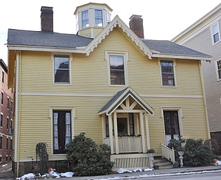
The William Ingersoll Bowditch House is a historic house at 9 Toxteth Street in Brookline, Massachusetts. It is a good example of vernacular Gothic and Greek Revival architecture, built c. 1844-45 as part of one of Brookline's earliest formal residential subdivisions. William Bowditch, the first owner, was an active abolitionist who sheltered fugitive slaves as part of the Underground Railroad, and was a member of the Boston Vigilance Committee. The house was listed on the National Register of Historic Places on October 17, 1985.

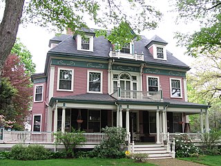
The Cottage Farm Historic District is a residential area in eastern Brookline, Massachusetts, United States, known for its association with industrialist Amos Adams Lawrence (1814–1886). Laid out in the 1850s and centered around the junction of Essex and Ivy Streets, it features high-quality housing on large lots, built between the 1850s and 1910s. The district was listed on the National Register of Historic Places in 1978.

Walnut Hills Cemetery is a historic cemetery on Grove Street and Allandale Road in Brookline, Massachusetts. It encompasses 45.26 acres (18.32 ha), with mature trees and puddingstone outcrops, and was laid out in 1875 in the then-fashionable rural cemetery style. Many past prominent citizens of the town, including architect H. H. Richardson, are buried here. The cemetery was listed on the National Register of Historic Places in 1985.


