Wedderburn, Oregon

Last updated

Wedderburn, Oregon
IsaacLeePattersonBridgeSE.jpg
Wedderburn can be seen from across the Isaac Lee Patterson Bridge.
USA Oregon location map.svg
Red pog.svg
Wedderburn
Location within the state of Oregon
Usa edcp location map.svg
Red pog.svg
Wedderburn
Wedderburn (the United States)
Coordinates: 42°25′58″N124°25′24″W / 42.43278°N 124.42333°W / 42.43278; -124.42333
Country United States
State Oregon
County Curry
Area
[1]
  Total
1.26 sq mi (3.26 km2)
  Land1.06 sq mi (2.74 km2)
  Water0.20 sq mi (0.52 km2)
Elevation
[2]
289 ft (88 m)
Population
 (2020) [3]
  Total
426
  Density403.03/sq mi (155.62/km2)
Time zone UTC-8 (Pacific (PST))
  Summer (DST) UTC-7 (PDT)
ZIP code
97444 [4]
Area codes 458 and 541
FIPS code 41-79500
GNIS feature ID2805463 [2]

Wedderburn is an unincorporated coastal community in Curry County, Oregon, United States. It is to the north of, and across the mouth of the Rogue River from Gold Beach, on U.S. Route 101. The Isaac Lee Patterson Bridge connects Wedderburn with Gold Beach.

Contents

History

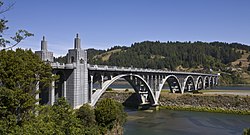
Wedderburn was founded by R. D. Hume, a prominent local businessman in the fishing industry, who named the community after the home of his ancestors, Wedderburn Castle in Scotland. [5] Wedderburn post office was established in 1895. [5]

Wedderburn was originally a company town for Hume's salmon fishing monopoly, and besides his fishing fleet, he ran Wedderburn's cannery, store, race track and cold storage plant. [6] Hume had settled at the mouth of the Rogue in 1876, and he eventually owned all the land on both banks of the river from the Pacific Ocean to the head of the tidewater. [6]

Climate

This region experiences warm (but not hot) and dry summers, with no average monthly temperatures above 71.6 °F (22.0 °C). According to the Köppen Climate Classification system, Wedderburn has a warm-summer Mediterranean climate, abbreviated "Csb" on climate maps. [7]

Education

It is in the Central Curry School District, [8] which operates two schools: Riley Creek Elementary School (K-8) and Gold Beach High School.

The entire county is in the Southwestern Oregon Community College district. [9]

Demographics

Historical population
CensusPop.Note
2020 426
U.S. Decennial Census [10] [3]

References

  1. "ArcGIS REST Services Directory". United States Census Bureau. Retrieved October 12, 2022.
  2. 1 2 U.S. Geological Survey Geographic Names Information System: Wedderburn, Oregon
  3. 1 2 "Census Population API". United States Census Bureau. Retrieved October 12, 2022.
  4. "Wedderburn OR ZIP Code". zipdatamaps.com. 2023. Retrieved June 16, 2023.
  5. 1 2 McArthur, Lewis A.; Lewis L. McArthur (2003) [1928]. Oregon Geographic Names (Seventh ed.). Portland, Oregon: Oregon Historical Society Press. pp. 1018–19. ISBN   0-87595-277-1.
  6. 1 2 "Oregon History: Emerging Economies". Oregon Blue Book . Oregon State Archives . Retrieved March 24, 2007.
  7. "Wedderburn, Oregon". Weatherbase. CantyMedia. Retrieved January 4, 2017.
  8. "2020 CENSUS - SCHOOL DISTRICT REFERENCE MAP: Curry County, OR" (PDF). U.S. Census Bureau . Retrieved July 16, 2022.
  9. "Oregon Community Colleges and Community College Districts" (PDF). Oregon Department of Community Colleges & Workforce Development . Retrieved July 17, 2022.
  10. "Census of Population and Housing". Census.gov. Retrieved June 4, 2016.

Further reading