Isaac Lee Patterson Bridge

Last updated

Isaac Lee Patterson Bridge
IsaacLeePattersonBridgeSE.jpg
Coordinates 42°25′38″N124°24′48″W / 42.4272°N 124.4133°W / 42.4272; -124.4133 Coordinates: 42°25′38″N124°24′48″W / 42.4272°N 124.4133°W / 42.4272; -124.4133
Carries2 lanes of US 101.svg US 101
Crosses Rogue River
Locale Gold Beach, Oregon to Wedderburn, Oregon
Maintained byState of Oregon
ID number 01172 009 32764
Characteristics
DesignConcrete arch-deck
Total length591 metres (1,939 ft)
Width8.2 metres (27 ft)
Longest span70 metres (230 ft), 7 spans
History
OpenedMay 28, 1932
Statistics
Daily traffic 6200
Location
Isaac Lee Patterson Bridge
Rogue River Bridge No. 01172
USA Oregon location map.svg
Red pog.svg
Usa edcp location map.svg
Red pog.svg
LocationOR Coast 9, US 101, MP 327.70, Gold Beach, Oregon
Area2.6 acres (1.1 ha)
Built1932
ArchitectConde B. McCullough; Mercer-Fraser Co.
MPS McCullough, C. B., Major Oregon Coast Highway Bridges MPS
NRHP reference No. 05000814 [1]
Added to NRHPAugust 5, 2005

The Isaac Lee Patterson Bridge, also known as the Rogue River Bridge and the Isaac Lee Patterson Memorial Bridge, is a concrete arch bridge that spans the Rogue River in Curry County, Oregon. The bridge was constructed by the Mercer Fraser Company of Eureka, California. The bridge carries U.S. Route 101 across the river, near the point where the river empties into the Pacific Ocean, and connects the towns of Gold Beach and Wedderburn. A bridge with strong Art Deco influences, the Isaac Lee Patterson Bridge is a prominent example of the designs of the Oregon bridge designer and highway engineer Conde McCullough. It was designated a National Historic Civil Engineering Landmark by the American Society of Civil Engineers in 1982. It is part of a series of notable bridges designed by McCullough for the Oregon Coast Highway in the 1930s. It was placed on the National Register of Historic Places in 2005.

Contents

History

The Oregon State Highway Department awarded the $568,181.00 ($9.22 million in 2021 dollars [2] ) construction contract to the Mercer, Fraser Company of Eureka, California, on January 16, 1930. Work began on the bridge at Gold Beach in April 1930. In order to avoid problems with concrete shrinkage that had plagued concrete arch bridges in the past, McCullough used the Freyssinet method of pre-tensioning the arches during construction using hydraulic jacks, using sixteen 250-ton jacks from Freyssinet's firm, enough to work with two arch panels at a time. McCullough's design was the first usage of this technique in the United States. [3] The remote location of the building site presented a significant challenge, with reinforcing steel shipped southward from Port Orford, and built a concrete plant on the north bank of the river. Pilings for the piers were obtained locally. The bridge was planned to open in January 1932, but the ferry Rogue was damaged in December 1931 flooding and the bridge opened early, on December 24, 1931. [4] It was dedicated on May 28, 1932 and named after Isaac Lee Patterson, the governor of Oregon from 1927 to 1929. The Mercer-Fraser Company presented the new bridge to the State on January 21, 1932, and the bridge was officially accepted as complete on January 27, 1932, at a final cost of $592,725.56. [5]

Description

The bridge is 1,938 feet (591 m) long and consists of seven 230-foot (70 m) deck arch spans and nine deck girder sections. [6] The roadbed is 27 feet (8.2 m) wide, and the structure is 34 feet (10 m) wide overall. Piers 1 and 8, at the ends, rest on solid rock. The intermediate piers rest on driven timber pilings. Piers 2, 4, 5, and 7 rest on 180 vertical piles, while piers 3 and 6, required to resist lateral thrust, have 260 piers driven at an angle. [4]

The detailing of the bridge incorporates Art Deco motifs, with prominent pylons at the ends with stepped Moderne elements and stylized Palladian windows crowned by sunbursts. The railings use a simplified, rectilinear Tuscan order with arches on short ribbed columns. [4]

The bridge has required extensive preventive maintenance to mitigate deterioration due to the location's salt air. A $20 million rehabilitation ran from 2001 to 2004. A previous project in 1976 mitigated scouring problems at pier 2. [4]

Construction of the bridge required the excavation of 10,174 cubic yards (7,779 m3) of earth and consumed 27,016 linear feet (8,234 m) of piling, 15,591 cubic yards (11,920 m3) of concrete, 1,764,981 pounds (800,582 kg) of reinforcing steel, and 114,109 pounds (51,759 kg) of structural steel. [5]

Designation

Entrance pylons Patterson Bridge (Curry County, Oregon scenic images) (curD0012).jpg
Entrance pylons

The Isaac Lee Patterson Bridge was placed on the National Register of Historic Places on August 5, 2005. [1]

Further reading

See also

Related Research Articles

<span class="mw-page-title-main">Oregon City Bridge</span> Bridge in Oregon, United States

The Oregon City Bridge, also known as the Arch Bridge, is a steel through arch bridge spanning the Willamette River between Oregon City and West Linn, Oregon, United States. Completed in 1922, it is listed on the National Register of Historic Places. It was built and is owned by the Oregon Department of Transportation (ODOT) as part of Oregon Route 43 and is the third-southernmost Willamette bridge in the Portland metropolitan area, after the Boone Bridge in Wilsonville and the Oregon 219 bridge near Newberg.

<span class="mw-page-title-main">Alsea Bay Bridge</span> Bridge in near Waldport, Oregon

The Alsea Bay Bridge is a concrete arch bridge that spans the Alsea Bay on U.S. Route 101 (US 101) near Waldport, Oregon.

<span class="mw-page-title-main">Conde McCullough Memorial Bridge</span> Bridge in North Bend, Oregon

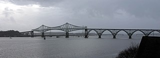
The Conde B. McCullough Memorial Bridge, is a cantilever bridge that spans the Coos Bay on U.S. Route 101 near North Bend, Oregon. When completed in 1936 it was named the North Bend Bridge. In 1947 it was renamed in honor of Conde B. McCullough who died May 5, 1946. This and 10 other major bridges on the Oregon Coast Highway were designed under his supervision.

<span class="mw-page-title-main">Yaquina Bay Bridge</span> Bridge in Newport, Oregon

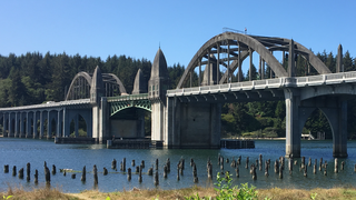
The Yaquina Bay Bridge is an arch bridge that spans Yaquina Bay south of Newport, Oregon. It is one of the most recognizable of the U.S. Route 101 bridges designed by Conde McCullough and one of eleven major bridges on the Oregon Coast Highway designed by him. It superseded the last ferry crossing on the highway.

<span class="mw-page-title-main">Siuslaw River Bridge</span> Bridge in Florence, Oregon

The Siuslaw River Bridge is a bascule bridge that spans the Siuslaw River on U.S. Route 101 in Florence, Oregon. It was designed by Conde McCullough, built by the Mercer-Fraser Company of Eureka, California, and funded by the Federal Emergency Administration of Public Works. It opened in 1936.

<span class="mw-page-title-main">Big Creek Bridge (Oregon)</span> United States historic place

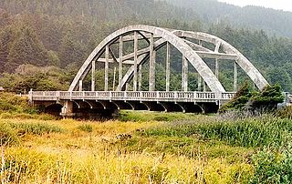
The Big Creek Bridge is a bowstring arch bridge that spans the Big Creek on U.S. Route 101 in Lane County, Oregon. It was designed by Conde McCullough and opened in 1931.

<span class="mw-page-title-main">Umpqua River Bridge</span> Bridge in Reedsport, Oregon

The Umpqua River Bridge is a swing-span bridge that spans the Umpqua River in Reedsport, Oregon. It consists of a central swing span flanked by two reinforced concrete arches on each end. The swing span was necessary to accommodate tall sailing vessels which were common on the Umpqua River. The final cost of the bridge was $510,500.

<span class="mw-page-title-main">Conde McCullough</span> American architect

Conde Balcom McCullough was an American civil engineer who is primarily known for designing many of Oregon's coastal bridges on U.S. Route 101. The native of South Dakota worked for the Oregon Department of Transportation from 1919 to 1935 and 1937 until he died in 1946. McCullough also was a professor at Oregon State University.

<span class="mw-page-title-main">Bridal Veil Falls (Oregon)</span> Waterfall located in Oregon

The Bridal Veil Falls is a waterfall located on Bridal Veil Creek along the Columbia River Gorge in Multnomah County, Oregon, United States. The waterfall is accessible from the historic Columbia River Highway and Interstate 84. Spanning two tiers on basalt cliffs, it is the only waterfall which occurs below the historic Columbia Gorge Scenic Highway. The Bridal Veil Falls Bridge, built in 1914, crosses over the falls, and is listed on the National Register of Historic Places.

<span class="mw-page-title-main">Crooked River High Bridge</span> Bridge in Jefferson County, Oregon

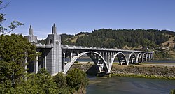
The Crooked River High Bridge is a steel arch bridge that spans the Crooked River gorge in Jefferson County, Oregon. The bridge was designed by Conde McCullough and was completed in 1926. Shortly after its completion, Oregon State Highway Division created the Peter Skene Ogden Park just to the south of the bridge.

<span class="mw-page-title-main">Lewis and Clark River Bridge</span> Bridge in near Astoria, Oregon

The Lewis and Clark River Bridge is a bascule bridge that spans the Lewis and Clark River on U.S. Route 101 Business in Clatsop County, Oregon. It was designed by Conde McCullough and opened in 1925. It was built to replace an earlier bridge at the same location, a swing-span bridge constructed around 1910.

<span class="mw-page-title-main">Cape Creek Bridge</span> United States historic place

Cape Creek Bridge is an arch bridge that spans Cape Creek in Lane County, Oregon, United States. The bridge carries U.S. Route 101. Opened in 1932, it was designed by noted bridge engineer Conde McCullough and built of reinforced concrete by John K. Holt. The total length of the bridge is 619 feet (189 m), with a main span of 220 feet (67 m). The bridge resembles a Roman aqueduct, with a single parabolic arch that spans half its length. It was listed as Cape Creek Bridge No. 01113 on the National Register of Historic Places in 2005, as part of the C. B. McCullough Major Oregon Coast Highway Bridges MPS.

<span class="mw-page-title-main">Wilson River Bridge</span> United States historic place

Wilson River Bridge, also known as Wilson River Bridge at Tillamook or Wilson River Bridge No. 01499, is a bridge near Tillamook, Oregon, United States. The 1931 bridge was designed by Conde McCullough in the Classical Revival and Art Deco styles. It covers a span of 180 feet (55 m) and brings coastal U.S. Route 101 (US 101) over the Wilson River.

<span class="mw-page-title-main">Ten Mile Creek Bridge (Oregon)</span> United States historic place

Ten Mile Creek Bridge is a Conde McCullough-designed bridge near Yachats in Lane County in the U.S. state of Oregon. It was listed on the National Register of Historic Places in 2005.

<span class="mw-page-title-main">Old Youngs Bay Bridge</span> Bridge in Astoria, Oregon

The Old Youngs Bay Bridge is a bascule bridge across Youngs Bay in Astoria, Oregon completed in 1921. Conde McCullough was responsible for designing this bridge, his first for Oregon.

<span class="mw-page-title-main">Kettle Falls Bridges</span> Bridge in Kettle Falls, Washington

The Kettle Falls Bridges is the collective name for a pair of steel cantilever bridges carrying State Route 20/U.S. Route 395 and the Kettle Falls International Railway across the Columbia River at Kettle Falls, Washington. The south bridge carries motor vehicle traffic while the similar northern span is used for rail.

<span class="mw-page-title-main">Yale Bridge</span> United States historic place

The Yale Bridge or Lewis River Bridge spans the Lewis River near Yale, Washington. It was built in 1932 by Cowlitz and Clark counties. The suspension bridge has a clear span of 300 feet (91 m), with a total length of 532 feet (162 m), replacing a previous steel truss bridge at the site. Construction of the Ariel Dam had created Lake Merwin with a water depth of 90 feet (27 m) at the site, requiring a new bridge that did not need to have support piers in the water. The road deck, stiffened by a steel Warren truss, is 50 feet (15 m) above the high water line of the reservoir.

<span class="mw-page-title-main">Depoe Bay Bridge</span> United States historic place

The Depoe Bay Bridge is one of a series of significant bridges along the Oregon Coast Highway. The concrete arch bridge spans the mouth of Depoe Bay at milepost 127.61 with a 150-foot (46 m) main span, and a total length of 312 feet (95 m). The bridge's designer was Conde McCullough who designed all of the 1920s bridges on the highway. The original bridge, completed in 1927, was only 18 feet (5.5 m) wide from curb to curb with no sidewalks, and was widened in 1940 with a similar arched concrete bridge immediately adjacent to the original. The added structure is sympathetic to the original and is included in the National Register of Historic Places listing.

<span class="mw-page-title-main">Rocky Creek Bridge No. 01089</span> United States historic place

Rocky Creek Bridge No. 01089, also known as Ben Jones Bridge, is a concrete highway bridge spanning Rocky Creek along the Pacific Ocean coast of the U.S. state of Oregon. The bridge crosses a gorge near the creek's mouth, about 2 miles (3 km) south of Depoe Bay in Lincoln County. Built in 1927, the bridge originally carried U.S. Route 101 over the creek. After a stretch of the highway was relocated to make it straighter, the abandoned piece of the old highway became Otter Crest Loop Road, a bypass west of the new highway.

<span class="mw-page-title-main">Hassayampa Bridge</span> United States historic place

The Hassayampa Bridge is a bridge spanning the Hassayampa River in Hassayampa, Arizona, located in Maricopa County. The bridge was completed in 1929 and was listed on the National Register of Historic Places in 1988. The bridge was scheduled for demolition in 1983.

References

  1. 1 2 "National Register Information System". National Register of Historic Places . National Park Service. July 9, 2010.
  2. 1634–1699: McCusker, J. J. (1997). How Much Is That in Real Money? A Historical Price Index for Use as a Deflator of Money Values in the Economy of the United States: Addenda et Corrigenda (PDF). American Antiquarian Society. 1700–1799: McCusker, J. J. (1992). How Much Is That in Real Money? A Historical Price Index for Use as a Deflator of Money Values in the Economy of the United States (PDF). American Antiquarian Society. 1800–present: Federal Reserve Bank of Minneapolis. "Consumer Price Index (estimate) 1800–" . Retrieved April 16, 2022.
  3. Hadlow, Robert W. (2001). Elegant Arches, Soaring Spans: C. B. McCullough, Oregon's Master Bridge Builder. Oregon State University Press. pp. 69–79. ISBN   0-87071-534-8.
  4. 1 2 3 4 Hadlow, Robert W. (June 30, 2004). "Rogue River Bridge No. 01172" . Retrieved August 31, 2012.
  5. 1 2 Bottenberg, Ray (2006). Bridges of The Oregon Coast. Charleston, South Carolina: Arcadia Publishing. pp. 11–26. ISBN   978-0-7385-4860-9.
  6. "Oregon Coastal Highway Bridges". Oregon Department of Transportation. Archived from the original on September 6, 2008. Retrieved June 27, 2008.