
Spring Hill is a ridge in the central part of the city of Somerville, Massachusetts, United States, and the residential neighborhood that sits atop it. It runs northwest to southeast, roughly bounded by Highland Avenue, Somerville Avenue, Elm Street, and Willow Avenue. Summer Street runs along the hill's crest.

The Broad Street Historic District encompasses a well-preserved 19th-century residential area in Middletown, Connecticut, USA. Centered on Broad and Pearl Streets west of Main Street, the area was developed residential in response to local economic development intended to revitalize the city, whose port was in decline. The district includes the city's largest concentration of Greek Revival houses, and was listed on the National Register of Historic Places in 1988.

Hillcrest Historic District is a historic neighborhood in Little Rock, Arkansas that was listed on the National Register of Historic Places on December 18, 1990. It is often referred to as Hillcrest by the people who live there, although the district's boundaries actually encompass several neighborhood additions that were once part of the incorporated town of Pulaski Heights. The town of Pulaski Heights was annexed to the city of Little Rock in 1916. The Hillcrest Residents Association uses the tagline "Heart of Little Rock" because the area is located almost directly in the center of the city and was the first street car suburb in Little Rock and among the first of neighborhoods in Arkansas.

The West Newton Hill NR Historic District is a residential National Register historic district in the village of West Newton, in the city of Newton, Massachusetts in the United States. It is composed of a cohesive collection of spacious houses built in the second half of the 19th century, representing the development of the West Newton area as a fashionable railroad suburb. The district was listed on the National Register of Historic Places in 1986.

The South Central Falls Historic District is a historic district in Central Falls, Rhode Island. It is a predominantly residential area, densely populated, which was developed most heavily in the late 19th century. It is bounded roughly by Broad Street to the east, the Pawtucket city line to the south, Dexter Street to the west, and Rand Street and Jenks Park to the north. It has 377 contributing buildings, most of which were built before 1920. The district was added to the National Register of Historic Places in 1991.

The East Cambridge Historic District encompasses the historic center of East Cambridge, Massachusetts. It includes the major buildings that were built to house county services for Middlesex County beginning in the 1810s, and a cluster of largely vernacular Greek Revival worker housing located west of the county complex on Otis, Thorndike, Spring, and Sciarappa Streets. The district was listed on the National Register of Historic Places in 1983.

The Lincoln–Sunset Historic District is a residential historic district located west of the downtown area of Amherst, Massachusetts. Colloquially known as Millionaire's Row, the district extends along Lincoln and Sunset Avenues between Northampton Street and the campus of the University of Massachusetts, Amherst. This area was one of Amherst's first planned residential subdivisions, and features a large number of high-quality houses, built by merchants, businessmen, and academics. It was added to the National Register of Historic Places in 1993.
The Diamond Historic District is a seaside, 69.5-acre (28.1 ha) National Register historic district in Lynn, Massachusetts. Established by the National Park Service in 1996, the district is situated between downtown Lynn and the Atlantic Ocean—bounded roughly by Broad and Lewis Streets to the north, Lynn Shore Drive to the southeast, Nahant Street to the west, and Eastern Avenue to the east. The Diamond Historic District encompasses 590 contributing resources.

The Pleasant–High Historic District encompasses the earliest area of non-agricultural residential development in Methuen, Massachusetts. It encompasses houses along High and Pleasant Streets from just east of Broadway to Vine Street, as well as a few that face on adjoining streets. The district was listed on the National Register of Historic Places in 1984; on its western boundary it abuts the Spicket Falls Historic District.
The Spring Hill Historic District is a historic district roughly bounded by Summer, Central, Atherton, and Spring Streets in the Spring Hill area of Somerville, Massachusetts. The district encompasses the city's best-preserved residential subdivision from the mid-19th century, with later infill construction in the late 19th and early 20th centuries. The district was listed on the National Register of Historic Places in 1989.

The Kensington Park Historic District of Arlington, Massachusetts encompasses a turn of the 20th century planned residential subdivision in the hills above the town center, representing an early phase in the town's transition from a rural to suburban setting. The district consists of most of the houses on Brantwood and Kensington Roads, which wind around a rocky hillside overlooking Pleasant Street and Spy Pond, just west of the center. A number of the houses are the work of architect C. Herbert McClare, who also lived in the area, and was one of the development's proponents. The district was listed on the National Register of Historic Places in 1985.

The Everett Avenue–Sheffield Road Historic District is a historic district encompassing one of the finest residential districts from the turn of the 20th century in Winchester, Massachusetts. The district is roughly triangular in shape, bounded in the north by Bacon Street, on the west by Church Street, Sheffield West, and Sheffield Road, and on the south and heast by the Upper Mystic Lake and Mystic Valley Parkway. It is characterized by winding roads, with relatively large houses on well-proportioned lots. Most of the houses were built between 1890 and 1916, and all exhibit some architectural sophistication. A significant number of properties were designed by either F. Patterson Smith or Dexter Blaikie, two local architects. The district was listed on the National Register of Historic Places in 1989.

The Firth–Glengarry Historic District encompasses a residential area of Winchester, Massachusetts consisting of well-preserved high quality houses built mainly between 1880 and 1900. The district lies between Wildwood Street and Wedge Pond, and includes properties on Pine Street, Glengarry Road, Grassmere Avenue, Dix Street, and Wildwood Street; houses on Curtis Street and Curtis Circle, are excluded from the district. Much of the area was laid out by developer William Firth, and many of its houses were designed by Boston architect Robert Coit. The 13.44-acre (5.44 ha) district was listed on the National Register of Historic Places in 1989.
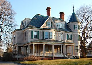
Oak Knoll is a historic estate house in Winchester, Massachusetts. This large Queen Anne/Colonial Revival house was built in the early 1890s by Lewis Parkhurst, a partner in the publishing house of Winchester resident Edwin Ginn. Parkhurst's mansion is the last surviving late 19th-century mansion house in Winchester. The house was listed on the National Register of Historic Places in 1989.

The Yale Avenue Historic District is a residential historic district near the center of Wakefield, Massachusetts. It encompasses eight residential properties, all but one of which were developed in the 1860s and 1870s, after the arrival of the railroad in town. These properties were built primarily for Boston businessmen, and mark the start of Wakefield's transition to a suburb.

Hammond Heights is an historic neighborhood subdivision on the west side of Worcester, Massachusetts. It includes properties along Germain, Haviland, Highland, and Westland Streets and Institute Road, most of which were built between 1890 and 1918, and is a good example of a turn-of-the-century residential subdivision, with a diversity of period architectural styles. The district was listed on the National Register of Historic Places in 1980.

Montvale is a residential historic district in northwestern Worcester, Massachusetts. It is a portion of a subdivision laid out in 1897 on the estate of Jared Whitman, Jr., whose property contained a single house, now 246 Salisbury Street. The central portion of this house was built in 1851 in a conventional Greek Revival style, and was expanded with the addition of side wings by the developers of the 1897 subdivision, H. Ballard and M. O. Wheelock.

Wakefield Park Historic District is a residential historic district encompassing a portion of a late-19th/early-20th century planned development in western Wakefield, Massachusetts. The district encompasses sixteen properties on 8 acres (3.2 ha) of land out of the approximately 100 acres (40 ha) that comprised the original development. Most of the properties in the district are on Park Avenue, with a few located on immediately adjacent streets.
The Crystal Lake and Pleasant Street Historic District encompasses a streetcar suburban residential subdivision developed between 1860 and 1895 in Newton, Massachusetts. The district roughly bounded by the Sudbury Aqueduct, Pleasant Street, Lake Avenue, Webster Court, and Crystal Street. The subdivision was laid out in the 1850s after the Boston and Charles Railroad line was extended through Newton from Brookline. The district was listed on the National Register of Historic Places in 1986.

The Pine Ridge Road–Plainfield Street Historic District encompasses a residential subdivision in the Waban section of Newton, Massachusetts. It includes 44 properties on Pine Ridge Road and Plainfield Street between Chestnut Street and Upland Road, and includes a few properties on the latter two streets. The area was laid out for development in the 1880s after the arrival of suburban rail service, and was built out by the 1930s. The district was listed on the National Register of Historic Places in 1990.


