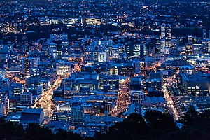

Wellington Central is an inner-city suburb of Wellington, and the financial heart of the both the city and the Wellington Region. It comprises the northern part of the central business district, with the majority of Wellington's high-rise buildings.
Wellington Central is an inner-city suburb of Wellington, and the financial heart of the both the city and the Wellington Region. It comprises the northern part of the central business district, with the majority of Wellington's high-rise buildings.
The majority of Wellington's High Street, Lambton Quay, runs through Wellington Central. From Lambton Quay the Wellington Cable Car is accessible.
Wellington Central is also home to Wellington's Civic Precinct, including Civic Square, the Wellington Town Hall, Wellington Central Library, the Michael Fowler Centre, and City Gallery Wellington. It is one of the few locations in New Zealand that is home to a number of high rise buildings, including the Majestic Centre, and Aon Centre (Wellington). [3]
Wellington Central consists of the flat, mostly reclaimed land, west of Lambton Harbour and the part of The Terrace immediately above it. It is bounded on the north by the suburb Pipitea (which includes Parliament Buildings) and extends as far south as Civic Square. The part of Wellington Central Business District south of Wellington Central is called Te Aro, which is the focus of Wellington's night-life. [4]
Wellington Central statistical area covers 0.56 km2 (0.22 sq mi). [1] It had an estimated population of 3,380 as of June 2021, [2] with a population density of 6,036 people per km2.
| Year | Pop. | ±% p.a. |
|---|---|---|
| 2006 | 1,992 | — |
| 2013 | 2,886 | +5.44% |
| 2018 | 3,000 | +0.78% |
| Source: [5] | ||
Wellington Central had a population of 3,000 at the 2018 New Zealand census, an increase of 114 people (4.0%) since the 2013 census, and an increase of 1,008 people (50.6%) since the 2006 census. There were 1,269 households. There were 1,437 males and 1,566 females, giving a sex ratio of 0.92 males per female. The median age was 26 years (compared with 37.4 years nationally), with 69 people (2.3%) aged under 15 years, 1,770 (59.0%) aged 15 to 29, 951 (31.7%) aged 30 to 64, and 210 (7.0%) aged 65 or older.
Ethnicities were 70.1% European/Pākehā, 6.7% Māori, 2.6% Pacific peoples, 26.4% Asian, and 3.4% other ethnicities (totals add to more than 100% since people could identify with multiple ethnicities).
The proportion of people born overseas was 41.4%, compared with 27.1% nationally.
Although some people objected to giving their religion, 57.8% had no religion, 22.8% were Christian, 5.7% were Hindu, 3.0% were Muslim, 2.4% were Buddhist and 4.0% had other religions.
Of those at least 15 years old, 1,290 (44.0%) people had a bachelor or higher degree, and 42 (1.4%) people had no formal qualifications. The median income was $25,300, compared with $31,800 nationally. The employment status of those at least 15 was that 1,356 (46.3%) people were employed full-time, 426 (14.5%) were part-time, and 207 (7.1%) were unemployed. [5]

Wellington City Council is a territorial authority in New Zealand, governing the country's capital city Wellington, and de facto second-largest city. It consists of the central historic town and certain additional areas within the Wellington metropolitan area, extending as far north as Linden and covering rural areas such as Mākara and Ohariu. The city adjoins Porirua in the north and Hutt City in the north-east. It is one of nine territorial authorities in the Wellington Region.

Berhampore is a suburb of Wellington, New Zealand. It lies towards the south of the city, four kilometres from the city centre, and two kilometres from the coast of Cook Strait. It is surrounded by the suburbs of Vogeltown, Newtown, Melrose, Island Bay, Kingston, and Mornington. The suburb was named after Berhampore in Bengal, one of the battlefields at the start of the Battle of Plassey of 1757. Also surrounding Berhampore is the Berhampore Golf Course as well as a very extensive green belt with many walkways and tracks connecting outlying areas. The suburb also boasts some of Wellington's best all weather sports fields, on Adelaide Road and the national hockey stadium. Alongside the golf course there is a skateboard/bmx park, right by a kids mountain bike track. Berhampore School opened in 1915.

Mount Victoria is a prominent hill 196 metres (643 ft) high immediately to the east of central Wellington, New Zealand. About 4 kilometres due south is a spur named Mount Albert and the two are linked by a ridge. Mount Victoria's residential area is on its north-western slopes.

Kelburn is a central suburb of Wellington, the capital city of New Zealand, situated within 1 kilometre (0.62 mi) of the central business district.

Thorndon is a historic inner suburb of Wellington, the capital city of New Zealand. Because the suburb is relatively level compared to the hilly terrain elsewhere in Wellington it contained Wellington's elite residential area until its best was destroyed in the 1960s by a new motorway and the erection of tall office buildings on the sites of its Molesworth Street retail and service businesses.

Mornington is a suburb of Wellington, New Zealand, on the southern hills behind Brooklyn. It is named after the Duke of Wellington's father, the Earl of Mornington. The original Mornington is in County Meath, and was the Irish seat of the Duke's father. It was named in 1878 from the time when J.F.E. Wright (1827-1891) subdivided his land in the south-west of the city in partnership with Jacob Joseph, and created the suburbs of Mornington and Vogeltown.

Mount Cook is an inner suburb of the metropolitan area of Wellington, The North Island, New Zealand, 1.74 km dead south of Wellington's Central Business District. Its local constituency area is the Wellington Central, and is part of the City of Wellington local government area. The suburb stands on the southern fringe of the central city alongside Te Aro and to the north of Newtown.
Lyall Bay is a bay and a suburb on the south side of the Rongotai isthmus in Wellington, New Zealand.

Kilbirnie is a suburb of Wellington in New Zealand, 3 kilometres (1.9 mi) to the south-east of the city centre. Travellers can reach Kilbirnie from the Wellington central business district via the Mount Victoria Tunnel and Hataitai, or over Mount Victoria, or around the coast.

Wilton is a small suburb in Wellington. It is best known for Otari-Wilton's Bush, a large reserve that is situated in the suburb. Otari-Wilton's bush is the only public botanic garden in New Zealand dedicated solely to native plants. It features 14 km of walking tracks and a 'canopy walkway'. The canopy walkway is a raised walkway that provides a unique chance to view life in, and from, the top level of trees such as mature tawa, rewarewa and hinau.

Boulcott is a central suburb of Lower Hutt City situated in the south of the North Island of New Zealand. The suburb lies about a kilometre north-east of the Lower Hutt CBD.

Ōwhiro Bay is a southern suburb of Wellington, New Zealand, that overlooks Cook Strait. It is situated west of the larger suburb of Island Bay. The official name of the suburb was changed from Owhiro Bay to Ōwhiro Bay by the New Zealand Geographic Board on 21 June 2019. The Bay and stream are named after the navigator Whiro, who landed the waka Nukutere there, and has been historically settled by the Kati Mamoe, Ngati Ira and Ngai Tara tribes.

Ohariu is a suburb of Wellington, New Zealand. It is a rural area, located 5 kilometres (3.1 mi) from Khandallah.

Strathmore Park is a suburb of Wellington City, New Zealand. It is located at the southern end of the Miramar Peninsula to the south of the suburb of Miramar, and due east of the airport. A hill suburb, it overlooks Lyall Bay, Evans Bay and several bays along the Seatoun coast close to the mouth of Wellington Harbour, which lies to the east.

Karaka Bays is a suburb of Wellington, New Zealand. It lies on the northeast coast of the Miramar Peninsula, 6 km east-south-east of the city centre, and has an expansive view of Wellington Harbour. It takes its name from a New Zealand native tree, the karaka or New Zealand laurel.

Takapu Valley, one of the northern suburbs of Wellington, New Zealand, is a rural area. The only road, Takapu Road, which runs by the Takapu Stream, goes down past Grenada North to the intersection with the Johnsonville-Porirua Motorway, and to Tawa where most facilities are. There is a supermarket and the Takapu Road Railway Station near the motorway intersection, but neither are in the valley itself.

Maupuia on the Miramar Peninsula is an eastern suburb of Wellington to the north-west of Miramar. Developed in the 1970s, it is in the Eastern Ward.

Broadmeadows is a minor western suburb of Wellington, New Zealand. It is located to the north of Khandallah and south of Johnsonville. It is located 7 kilometres (4.3 mi) from the Wellington central business district. Despite its name suggesting that the area was once flat open fields, the suburb was created on steeply sloping hills and features the highest streets within Wellington City with a number of houses located more than 300m above sea level. Broadmeadows has a population of 1,635.
Porirua Central is the central business district and central suburb of Porirua, in the Wellington region of New Zealand's North Island.
Pipitea is a central suburb of Wellington, in the Wellington region of New Zealand's North Island.