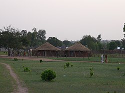
Gabú Region is the easternmost region in Guinea-Bissau. Its capital is Gabú. The region borders Senegal to the north, Guinea to the east and south and the Guinea-Bissau regions of Tombali and Bafatá to the west. It covers an area of 9,150 km2, making it the largest of Guinea-Bissau's administrative regions. It is an inland region covered with Savannah or light Savannah woodland and receives an annual rainfall of more than 2,000 mm (79 in).
Oio is a region in Guinea-Bissau. Its capital is Farim. Other major cities and towns include Nhacra, Mansôa, Bissorã and Cumeré. The region borders Senegal to the north, the Guinea-Bissau regions of Bafatá, Bissau and Biombo to the east, the Rio Geba/Guinea-Bissau region of Quinara to the south and the Guinea-Bissau region of Cacheu to the west. There has not been any local administration since the civil war of 1998-99 and all the social services are done by organs of civil society and other government agencies. It is a coastal region covered with Mangrove swamps, rain forest and tangled forest and receives an annual rainfall of more than 1,000 mm (39 in), while the inland has Savannah woodlands.
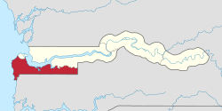
Trarza is a region in southwest Mauritania. Its capital is Rosso. Other major cities and towns include Mederdra and Boutilimit. Trarza borders the regions of Inchiri and Adrar to the north, Brakna to the east, and the country of Senegal to the south. Its western coastline on the Atlantic Ocean is interrupted only by the Mauritanian capital Nouakchott, which the region completely surrounds.

Hodh El Gharbi is a region in southern Mauritania, with an area of 53,400 square km. The population at the 2013 census was 294,109. Its capital is Aïoun. The region borders the Mauritanian regions of Tagant to the north, Hodh Ech Chargui to the east and Assaba to the west. To the south in borders Mali, and a part of Malian territory protrudes into the region. The Aoukar basin, which formerly gave name to a greater region, is located in the northern and central part of Hodh El Gharbi, extending eastwards.

Hodh Ech Chargui is a large region in eastern Mauritania, with an area of 182,700 km2. Its capital is Néma, but the largest town, in Bassiknou Department, is Fassala at the extreme southeast of Mauritania, with 65,927 inhabitants at the 2013 census. The region borders the Mauritanian regions of Adrar, Tagant and Hodh El Gharbi to the west and Mali to the east and south. The Aoukar basin, which formerly gave name to a greater region, is located in the western part of Hodh Ech Chargui.

Guidimaka is the southernmost region of Mauritania. Its capital is Sélibaby. The region borders the Mauritanian region of Assaba to the north-east, Mali to the south-east, Senegal to the south-west and the Mauritanian Gorgol Region to the west.

Gorgol is a region in southern Mauritania. Its capital is Kaédi and the Gorgol River forms parts of the landscape. Other major cities/towns include Mbout and Maghama. The region borders the Mauritanian regions of Brakna and Assaba to the north, the Mauritanian region of Guidimaka to the south-east and Senegal to the south-west. The Senegal River runs along the region's border with Senegal.

Brakna is a region in south-west Mauritania. Its capital is Aleg. Other major cities/towns include Boghé. The region borders the Mauritanian regions of Tagant to the north-east, Assaba and Gorgol to the south-east, and Trarza to the north-west. The Sénégal River in the south-west runs along the region's border with Senegal.

Assaba is a region in southern Mauritania, covering an area of 36,600 square km. It had a population of 325,897 at the 2013 Census. Its capital is Kifa. Other major cities/towns include Guerou. The region borders the Mauritanian regions of Brakna and Tagant to the north, the Mauritanian region of Hodh El Gharbi to the east, Mali to the south, and the Mauritanian regions of Gorgol and Guidimaka to the west. The Aoukar basin, which formerly gave name to the greater region, is located in the north and the east of the central part of Assaba.

Anseba Region is one of the six administrative regions, located in northern Eritrea. The capital and the most populous city in the region is Keren. The region is named after Anseba River, which passed through most parts of the region. The average elevation in the region is around 1,800 m (5,900 ft) to 2,100 m (6,900 ft). The hottest month is May recording temperatures up to 30 °C (86 °F), while the coldest month is December to February when it reaches freezing temperature. The region received around 508 mm (20.0 in) of rainfall and the soil is conducive for agriculture.

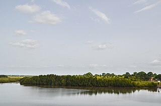
Cacheu is a region in western Guinea-Bissau, on the border with Senegal. It has an area of 5,175 km2 and a population estimated in 2004 at 164,676. Its capital is Cacheu. There has not been any local administration since the civil war of 1998-99 and all the social services are done by organs of civil society and other government agencies. It is a coastal region covered with Mangrove swamps, rain forest and tangled forest and receives an annual rainfall of more than 1,000 mm (39 in)

Debub Region, also known as the Southern Region, is a region of Eritrea. The region was formed on 15 April 1996, from the historical provinces of Serae and Akele Guzai. It lies along a portion of the national border with Ethiopia. As of 2005, the region had a population of 952,100 compared to a population of 839,700 in 2001. The net growth rate was 11.81 per cent. The total area of the province was 8000.00 km2 and the density was 119.01 persons per km2. The highest point in Eritrea, is Mount Soira 3,018 m (9,902 ft), is located in the region, situated east of Senafe. It shares borders with Central Region in the north, Zoba Northern Red Sea in the east, Gash Barka in the west and Ethiopia in the south. It is the largest region in the country by population.

Lower River Division is one of the five administrative divisions of the Gambia. Its capital is Mansa Konko. The city and area council elections were held during April 2002, when Wally S.M. Sanneh, an APRC candidate became the Mayor, winning unopposed. The council was led by Alliance for Patriotic Reorientation and Construction (APRC), which won all the 12 seats.

Central River was the largest of the five administrative divisions of the Gambia. Its capital was Janjanbureh, on MacCarthy Island. The largest settlement was Bansang, with an estimated population in 2008 of 8,381.

North Bank was one of the five administrative divisions of the Gambia. Its capital was Kerewan. It was subsequently reorganised as the Kerewan Local Government Area (LGA), without any change in the area covered.

Upper River was one of the five Divisions of the Gambia. Its capital was Basse Santa Su. It was subsequently reorganised as the Basse Local Government Area, without any change in the area covered.

The Trans-Gambia Highway is the most important road in The Gambia, running across the centre of the nation in a north–south direction.
The Gambia is subdivided into 43 districts. They are listed below, by Local Government Area, each with its population at the 15 April 2013 Census.

The Gambia is divided into five administrative Regions and one City. The divisions of the Gambia are created by the Independent Electoral Commission in accordance to Article 192 of the National Constitution.
Kombo North/Saint Mary is one of the nine districts of the Gambia's Brikama Local Government Area, which is located to the south of the Gambia River in the southwest of the country. Kombo North/Saint Mary is in the northwest of the LGA, between Kombo South and Kanifing LGA. It is the only district in the LGA with coasts on both the Atlantic Ocean and the Gambia River, and is the most populated district in the LGA, with 344,756 inhabitants at the 2013 Census.