
Yorkshire and the Humber is one of the nine official regions of England at the first level of ITL for statistical purposes. It is one of the three regions covering Northern England, alongside the North West England and North East England regions, and covers the historic and cultural Yorkshire area.

Sheffield is a city in South Yorkshire, England, situated 37 miles (60 km) south of Leeds and 38 miles (61 km) east of Manchester. The city serves as the administrative centre of the City of Sheffield. It is historically part of the West Riding of Yorkshire and some of its southern suburbs were transferred from Derbyshire to the city council. It is the largest settlement in South Yorkshire as well as the third largest of Northern England.

Glossop is a market town in the borough of High Peak, Derbyshire, England, 15 miles (24 km) east of Manchester, 24 miles (39 km) north-west of Sheffield and 32 miles (51 km) north of Matlock. Near Derbyshire's borders with Cheshire, Greater Manchester, South Yorkshire and West Yorkshire, between 150 and 300 metres above sea level, it is bounded by the Peak District National Park to the south, east and north. In 2021, it had a population of 17,825.

The University of Sheffield is a public research university in Sheffield, South Yorkshire, England. Its history traces back to the foundation of Sheffield Medical School in 1828, Firth College in 1879 and Sheffield Technical School in 1884. University College of Sheffield was subsequently formed by the amalgamation of the three institutions in 1897 and was granted a royal charter as University of Sheffield in 1905 by King Edward VII.

The A57 is a major road in England. It runs east from Liverpool to Lincoln via Warrington, Salford and Manchester, and then through the Pennines over the Snake Pass (between the high moorlands of Bleaklow and Kinder Scout), around the Ladybower Reservoir, through Sheffield and past Worksop. Between Liverpool and Glossop, the road has largely been superseded by the M62, M602 and M67 motorways. Within Manchester a short stretch becomes the Mancunian Way, designated A57(M).

High Peak is a local government district with borough status in Derbyshire, England, covering a high moorland plateau in the Dark Peak area of the Peak District National Park. The district stretches from Holme Moss in the north to Sterndale Moor in the south, and from Hague Bar in the west to Bamford in the east. The population of the borough taken at the 2011 Census was 90,892. The borough is unusual in having two administrative centres for its council, High Peak Borough Council; the offices are in Buxton and Glossop. Other towns include Chapel-en-le-Frith, Hadfield, New Mills and Whaley Bridge.

Broomhill and Sharrow Vale — which includes the districts of Broomhill, Broomhall, Crookesmoor, Endcliffe, Sharrow Vale and Tapton Hill — is one of the 28 electoral wards in City of Sheffield, England. The ward was created following the 2015 local government boundary review out of parts of the old Broomhill, Central and Nether Edge wards. It is located in the western part of the city. The population of the Broomhill ward in 2011 was 16,966 people in 5,708 households, covering an area of 2.7 km2. Broomhill & Sharrow Vale is one of the wards that make up the Sheffield Central Parliamentary Constituency.

The Inner West of Sydney is an area directly west of the Sydney central business district, New South Wales, Australia. The suburbs that make up the Inner West are predominantly located along the southern shore of Port Jackson, stretching south to the shores of the Cooks River. The western boundary of the Inner West is approximately the A3 arterial road, which divides the Inner West from the Greater Western Sydney region. The Inner West is much larger than the Inner West Council local government area. The Inner West roughly corresponds with the Parish of Petersham and Parish of Concord, two cadastral divisions used for land titles.

The Eastern Suburbs is the eastern metropolitan region of Sydney, New South Wales, Australia.

Transport in Sheffield, England is developed around the city's unusual topography and medieval street plan. Once an isolated town, the transport infrastructure changed dramatically in the 19th and 20th centuries. The city now has road and rail links with the rest of the country, and road, bus and trams for local transport.
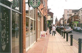
The Devonshire Quarter is an area in the centre of Sheffield, England. Its heart is the Division Street and Devonshire Street shopping areas, known for their small independent shops and variety of pubs and bars. The district also has The Forum shopping centre and Devonshire Green, one of the largest open areas in central Sheffield.

Sheffield City Centre is a district of the City of Sheffield and is covered partly by the City ward of the City of Sheffield. It includes the area that is within a radius of roughly 0.75 miles (1.2 km) of Sheffield Cathedral and is encircled by the Inner Ring Road, a circular route started in the late 1960s and completed in 2007. As well as the cathedral, buildings in the city centre include the Grade I listed Town Hall, the City Hall and the Winter Gardens. Several areas of the city centre have been designated as quarters. It is home to the city's major business, transport, leisure and cultural attractions.
Middlewood is a north western suburb of Sheffield, South Yorkshire, England. The suburb falls within the Stannington ward of the City.

Sheffield Inner Ring Road is a dual-carriageway circling central Sheffield, South Yorkshire, England. Marked up as the A61 all the way around, it was built from the 1960s onwards. The Ring Road connects to the Sheffield Parkway, which itself connects with the M1 motorway. Many of Sheffield's current and under construction major office premises and luxury apartments are located on the Ring Road.
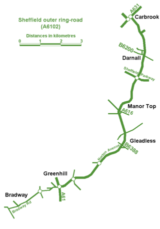
Sheffield Outer Ring Road is one of two main routes circumventing Sheffield, England, a partial ring around Sheffield City Centre and its suburbs.
Crookes is a suburb of the City of Sheffield, England, about 1.5 miles (2.4 km) west of the city centre. It borders Broomhill to the south, Walkley and Upperthorpe to the east and open countryside around the River Rivelin to the north. The population of the ward of the same name was 17,700 at the 2011 Census.

Birmingham city centre, also known as Central Birmingham, is the central business district of Birmingham, England. The area was historically in Warwickshire. Following the removal of the Inner Ring Road, the city centre is now defined as being the area within the Middleway ring road. In recent years the city centre has been undergoing massive redevelopment with the Big City Plan, which means there are now nine emerging districts and the city centre is approximately five times bigger.

The Mount is a Grade II* listed building situated on Glossop Road in the Broomhill area of Sheffield in England. It stands just over 1.3 miles (2.1 km) west of the city centre. It is a neoclassical building which was originally a terrace of eight houses but since the 1950s has been used for commercial office space for various businesses. The building is part of the Broomhill Conservation Area, which was set up in March 1977 through an agreement with local residents and Sheffield City Council.
The 1950s and 1960s saw the construction of numerous brutalist apartment blocks in Sheffield, England. The Sheffield City Council had been clearing inner-city residential slums since the early 1900s. Prior to the 1950s these slums were replaced with low-rise council housing, mostly constructed in new estates on the edge of the city. By the mid-1950s the establishment of a green belt had led to a shortage of available land on the edges of the city, whilst the government increased subsidies for the construction of high-rise apartment towers on former slum land, so the council began to construct high-rise inner city estates, adopting modernist designs and industrialised construction techniques, culminating in the construction of the award-winning Gleadless Valley and Park Hill estates.

The Western Bank Campus is the main campus of the University of Sheffield. It lies one mile to the west of Sheffield city centre and is bounded by Upper Hanover Street to the east, Glossop Road to the south, Clarkson Street to the west, and Winter Street to the north. The campus includes Firth Court, Alfred Denny Building, Western Bank library and Arts Tower, Geography and Planning building, Bartolomé House, Dainton and Richard Roberts Buildings, the Sheffield Students' Union building, the Octagon Centre, Graves Building, Hicks Building and the Information Commons. The nearest motorway is the A57.
