
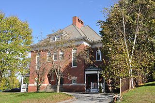
The Gardner Uptown Historic District is a historic district encompassing the former civic heart of Gardner, Massachusetts. The 65-acre (26 ha) area includes the old town common, an early cemetery, and a modest number of non-residential buildings among a larger number of houses. The area was the center of civic life from the incorporation of Gardner in 1785 until municipal functions were moved to West Gardner beginning in the late 1920s. The district was listed on the National Register of Historic Places in 1999.

The Templeton Common Historic District encompasses the historic town center of Templeton, Massachusetts. Laid out in the 1750s, the area has been the focus of the town's civic and economic affairs since, and includes its finest assortment of 18th and early 19th-century architecture. The district was added to the National Register of Historic Places in 1983. The district was in 2010 named as one of the 1,000 places to visit in Massachusetts by the Great Places in Massachusetts Commission.
The Baldwinville Village Historic District encompasses the historic elements of the village of Baldwinville, a 19th-century mill village in northern Templeton, Massachusetts. Although its industrial elements have largely been lost, the district retains period housing and civic buildings. It was listed on the National Register of Historic Places in 1986.

Mill River Historic District is a historic district encompassing the traditional center of government and a former industrial mill village along the Konkapot River in the village of Mill River in New Marlborough, Massachusetts. The district is roughly bounded by Main Street and River Church, Southfield, Clayton, School, and Hayes Hill Roads. It encompasses about 425 acres (172 ha), and contains mostly 19th century residential and civic buildings, as well as remnants of 19th century industrial activity.

The Upper North Street Commercial District is a historic district on the north side of downtown Pittsfield, Massachusetts, United States. Representing an expansion of Pittsfield's historic downtown area northward from Park Square in the late 19th century, the district encompasses primarily commercial buildings fronting on North Street between Columbus and Madison Avenues on the west side, and between Eagle and Maplewood Avenues on the east side. The notable exceptions are the Berkshire Eagle building, located on Eagle Street next to Sottile Park, and the St. Joseph's Church complex. The district features Colonial Revival and Renaissance style architecture. It was added to the National Register of Historic Places in 2002.

The North High Street Historic District is a historic district encompassing part of the downtown area of Holyoke, Massachusetts. When first added to the National Register of Historic Places in 1986, the district encompassed North High Street, between Dwight and Lyman Streets. This part of High Street was built between 1850 and 1885, and is lined with masonry buildings in Italianate and Second Empire styles. In 1992 the district was extended southward, adding three blocks of High Street between Dwight and Essex Streets. This expansions encompasses the growth of Holyoke during the height of its commercial success, between 1880 and 1930; it also includes the separately-listed Holyoke City Hall. The district was extended a third time, in 2008, adding a complex of three buildings at Dwight and Maple Streets that now houses the Holyoke Health Center.

The Machine Shop Village District is a historic district roughly bounded by Main, Pleasant, Clarendon, Water, 2nd Streets, and B&M Railroad in North Andover, Massachusetts. The district encompasses a well-preserved former textile mill village developed in the mid-19th century, with a variety of worker and upper-class housing, and two historic mill complexes. It was added to the National Register of Historic Places in 1982.

The Spicket Falls Historic District encompasses the historic industrial and commercial heart of Methuen, Massachusetts, and one of the lower Merrimack River's best-preserved 19th century mill complexes. It is centered on the falls of the Spicket River, from which the 19th century textile mills of Methuen derived their power. The historic district, listed on the National Register of Historic Places in 1984, includes commercial and civic buildings in and near Gaunt Square, the heart of the city, and along both sides of the Spicket River between Gaunt Square and the Boston and Maine Railroad tracks south of the river. It abuts the residential Pleasant-High Historic District, which lies to its east.

The Waterville Village Historic District encompasses most of the history 19th and early 20th-century village center of Waterville, Vermont. The village grew from beginnings late in the 18th century to serve as a modest civic, commercial, and residential hub for the rural community. It was added to the National Register of Historic Places in 2007.

The East Jaffrey Historic District is a historic district running roughly along NH Route 124 through Jaffrey, New Hampshire. It encompasses what is now the economic and civic heart of the town, centered on the Jaffrey Mills and the crossing of the Contoocook River by Route 124. It extends as far west as St. Patrick's Church beyond Charlonne Street and as far east as the US Post Office building at Route 124 and Ellison Street. To the north it extends along Peterborough Street to Christian Court, and to the south it extends along River Street and School Street to their junction. The district includes early 19th-century residential structures, as well as industrial buildings and housing associated with the Jaffrey Mills which arose in the mid-19th century. The district was added to the National Register of Historic Places in 2002.

The Westfield Center Historic District is a historic district encompassing 157 acres (64 ha) of the civic, commercial, and industrial heart of Westfield, Massachusetts. It represents a major expansion of the Westfield Center Commercial Historic District, which included only two blocks of buildings along Elm Street in downtown Westfield. The district includes buildings representing the city's growth in the 19th century as a center of the whip-making industry, and its early years as a center for statewide educational institutions, as well as its growth as a regional center of western Hampden County. The commercial district was added to the National Register of Historic Places in 2008; the expansion and renaming of the district took place in 2013.

The Chesterfield Center Historic District is a historic district that encompasses the traditional village center of the town of Chesterfield, Massachusetts. The village is reflective of the town's 18th and 19th-century development as an agrarian hill community, with architectural styles before about 1850 predominating. The district was listed on the National Register of Historic Places in 2000.

The Exeter Waterfront Commercial Historic District encompasses the historic commercial and residential waterfront areas of Exeter, New Hampshire. The district extends along the north side of Water Street, roughly from Main Street to Front Street, and then along both sides of Water and High streets to the latter's junction with Portsmouth Street. It also includes properties on Chestnut Street on the north side of the Squamscott River. This area was where the early settlement of Exeter took place in 1638, and soon developed as a shipbuilding center. The district was listed on the National Register of Historic Places in 1980. It was enlarged in 1986 to include the mill complex of the Exeter Manufacturing Company on Chestnut Street.

The Rochester Commercial and Industrial District encompasses the civic, commercial, and industrial heart of Rochester, New Hampshire. Oriented around the city's Central Square, the 6-acre (2.4 ha) district includes the city's major civic buildings, most of which are Classical Revival structures from the early 20th century, a number of commercial buildings dating as far back as the square's formation in the 1820s, and several late 19th-century industrial facilities. The district extends primarily along Main Street, from Bridge and Union Streets to Winter and Academy Streets, and includes properties extending along Wakefield and Hanson Streets, as well as other adjacent streets. The district was listed on the National Register of Historic Places in 1983.

The Downtown Bennington Historic District encompasses the historic commercial heart of Bennington, Vermont. Centered on the junction of Main, South, and North Streets, it exhibits a variety of commercial architectural styles from the early 19th to mid-20th century. It was listed on the National Register of Historic Places in 1980, and was enlarged in 2008.
The Springfield Downtown Historic District encompasses the historic central business district of the town of Springfield, Vermont. Located in a narrow valley on the banks of the Black River, the town's architecture is primarily reflective of its importance as a manufacturing center in the late 19th and early-to-mid 20th centuries, with a cluster of commercial buildings surrounded by residential and industrial areas. It was listed on the National Register of Historic Places in 1983, and enlarged slightly in 1986.

The Bristol Downtown Historic District encompasses the historic late 19th-century commercial heart of Bristol, Vermont. At first a rural agricultural market town, it developed in the second half of the 19th century as a small industrial center, producing finished wood products. Its downtown occupies an area of one block on both sides of Main Street, and features a diversity of architectural styles. It was listed on the National Register of Historic Places in 1983.

The City Hall Park Historic District encompasses one of the central economic, civic, and public spaces of the city of Burlington, Vermont. Centered on City Hall Park, the area's architecture encapsulates the city's development from a frontier town to an urban commercial center. The district was listed on the National Register of Historic Places in 1983.

The Moran Square Historic District is a historic district encompassing an area of late 19th and early 20th-century industrial, commercial, and residential development in Fitchburg, Massachusetts. Centered on the triangular junction of East Main Street with Lunenburg and Summer Streets, this area developed as a secondary node apart from the city's main commercial district, in an area were several industrial plants were undergoing significant growth. The district was listed on the National Register of Historic Places in 2018.

The Downtown Seymour Historic District encompasses most of the historic downtown of Seymour, Connecticut. Sandwiched between Connecticut Route 8 and the tracks of the former Naugatuck Railroad line, now the Waterbury Branch, it developed in the mid-19th century as a successful industrial center dominated by the production of brass goods. The district was listed on the National Register of Historic Places in 1983.


