
The Lunenburg Historic District is a historic district encompassing the historic center of Lunenburg, Massachusetts. The district is centered on a stretch of Main Street which connects two triangular intersections. It includes many of the town's oldest buildings, including the c. 1724 Cushing House, and the c. 1730 Stillman Stone House. Three of the town's most significant institutional buildings were built before 1850: the town hall, the Congregational church, and the Methodist church. The district was added to the National Register of Historic Places in 1988.

This is a list of the National Register of Historic Places listings in Detroit, Michigan.

The Harvard Center Historic District is a historic district encompassing the traditional village center of Harvard, Massachusetts, USA. The district is centered on the town common, a triangular grassy space bounded by Elm Street, Still River Road, and Ayer Road. The common is ringed by residences, civic and religious buildings, and a small commercial area. The common was laid out when the town was founded in 1732, and has grown, mainly in periods of growth at the late 18th and late 19th/early 20th centuries. Most of the village's buildings post-date 1831. The district was added to the National Register of Historic Places in 1997.

The Millis Center Historic District is an historic district on Curve, Daniels, Exchange, Irving, Lavender, Main, and Union Streets in Millis, Massachusetts. It encompasses the historic mid-to-late-19th century village center of the town, including the residential area north of Main Street, two 19th-century industrial complexes, and civic and institutional buildings. It was added to the National Register of Historic Places in 2007.

The McIntosh Corner Historic District is a historic district encompassing an area that was formerly the principal town center of Needham, Massachusetts. This cluster of mainly residential buildings, surrounding the junction of Great Plain Avenue and Central Street, declined in importance when the railroad bypassed it, resulting in the eventual relocation of the town's village center to its present location, about 1 mile (1.6 km) to the east. The district was added to the National Register of Historic Places in 1989.

The Charlemont Village Historic District is a historic district on Massachusetts Route 2 between South Street and Harmony Lane, encompassing much of the village center of Charlemont, Massachusetts, United States. The district's properties represent the growth of the village center from its rural origin through a period of 19th century industrialization, including 18th and 19th century farmsteads, Greek Revival buildings of the mid 19th century, and later 19th century Victorian architectural styles. The district was added to the National Register of Historic Places in 1988.

The Whately Center Historic District encompasses the historic rural village center of Whately, Massachusetts. Located in the hills west of the Connecticut River and north of Northampton, the district consists of a stretch of Chestnut Plain Road, the main north-south route through the village, and a short stretch of Haydenville Road, which is roughly at the center of the district. There are many fine homes from the Federal period, although they often have embellishments from later periods. Greek Revival architecture is also a major presence, with numerous houses, as well as the town's civic centerpieces, the town hall and Second Congregational Church, showing that style. There are only a modest number of 20th century structures in the district bounds. The district was listed on the National Register of Historic Places in 2003.

The Bradstreet Historic District encompasses the rural 19th-century village of Bradstreet in Hatfield, Massachusetts. It is centered at the junction of Depot Road and Main Street, and includes properties lining those two streets and Old Farm Road. Most of the buildings in the area date to the second half of the 19th century, featuring architectural styles typical of the period, including Queen Anne, Second Empire, Italianate, and Colonial Revival. The village grew on land that was originally granted to colonial governor Simon Bradstreet and divided in 1682, and has remained largely agricultural since then. The district was listed on the National Register of Historic Places in 1997.
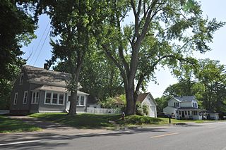
The Elm Street Historic District is a rural historic district in southern Hatfield, Massachusetts. It encompasses a landscape that has seen agricultural use since 17th century colonial days, including fields now used for tobacco farming, and historic properties located along five roads: Elm Street, Scotland Road, Sunset Road, Brook Hollow Road, and Little Neponset Road. The district is bounded on its south by the Connecticut River, on its east and north by the Mill River, with a small portion of land border in the northeast which cuts off a large meander in the river. This section, near the junction of Elm and Prospect Streets, is also where this district abuts the Mill-Prospect Street Historic District, which runs north along Prospect Street, and its eastern boundary abuts the Hatfield Center Historic District. Its western boundary is roughly a north-south line in the area of the junction of Elm and Dwight Streets.

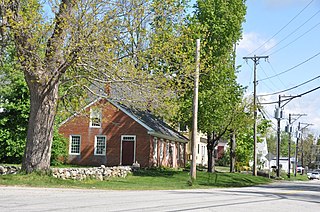
The Hatfield Center Historic District encompasses the traditional center of Hatfield, Massachusetts. The area, first laid out in 1661, is bounded by Maple Street to the south, the Connecticut River to the east, Day Avenue and School Street to the north, and the Mill River to the west. The area's layout and land use patterns are relatively little altered since they were laid out, leaving a well-preserved early colonial village landscape. The district was added to the National Register of Historic Places in 1994.

The North Hatfield Historic District encompasses a small rural village in Hatfield, Massachusetts. It consists of a small cluster of buildings along West Street and Depot Road in the vicinity of a former railroad station. It includes a few buildings associated with the railroad, including a depot and freight buildings, as well as commercial and residential structures, most of which postdate the 1848 arrival of the railroad. The village was important in the community as an arrival point for immigrants working in its fields and industry. The district was listed on the National Register of Historic Places in 1997.

The North Hadley Historic District encompasses the historic rural village of North Hadley, located between Mount Warner and the Connecticut River in Hadley, Massachusetts. It includes properties on River Drive between Stockwell Road and Stockbridge Street, and includes properties on French, Meadow and Mt. Warner Streets. It is a well-preserved example of a rural farming and mill community, with architecture dating from the late 18th to early 20th centuries. The district was listed on the National Register of Historic Places in 1993.

The Longmeadow Street–North Historic District encompasses a stretch of Longmeadow Street in northern Longmeadow, Massachusetts, from the town line with neighboring Springfield to Cooley and Westmoreland Streets in the south. It was listed on the National Register of Historic Places in 1994. The district's primarily residential architecture and streetscape is reflective of more than two centuries of development trends, and a late 19th-century desire to maintain a more rural atmosphere.

The Kendal Green Historic District is a rural residential district running along North Avenue in Weston, Massachusetts. It extends for about three-quarters of a mile, and includes elements representative of the development of Weston from a rural agricultural community to a residential suburb of Boston. In addition to a variety of predominantly residential and agricultural properties, it includes two formerly industrial sites important in Weston's history: the site of the Hobbs Tannery, and that of the Hook and Hastings Organ Factory. The district was listed on the National Register of Historic Places in 2000.

The Kinderhook Village District is located in the central areas of the village of Kinderhook, New York, United States. It is a 612-acre (248 ha) area covering both developed and undeveloped land centered on US 9.

The Hollis Village Historic District encompasses the historic village center of Hollis, New Hampshire. The district is centered on Monument Square, which connects Main Street to Depot Street and Broad Street. It covers about 400 acres (160 ha), and extends along all three of those roads for some distance, and includes properties on Silver Lake Road and Ash Street. Most of the buildings in the district are residential or agricultural in use, and date before the turn of the 20th century; the oldest buildings date to the mid-18th century. The "Always Ready Engine House", which occupies a triangular parcel at the western end of Monument Square, was built in 1859, and is the town's oldest municipal building. Its most architecturally sophisticated building is the town hall, built in 1887 to a design by William M. Butterfield of Manchester. The district represents the growth of a mainly agricultural community over a 200-year period. The district was listed on the National Register of Historic Places in 2001.

The Chesterfield Center Historic District is a historic district that encompasses the traditional village center of the town of Chesterfield, Massachusetts. The village is reflective of the town's 18th and 19th-century development as an agrarian hill community, with architectural styles before about 1850 predominating. The district was listed on the National Register of Historic Places in 2000.
The New Ipswich Center Village Historic District encompasses the historic center of the rural town of New Ipswich, New Hampshire. The center village is the town's most densely populated area, with a history dating to the town's founding in 1735. The district extends along Turnpike Road between King and Porter Roads, and southward in a roughly triangular shape, the southern point of which is at the junction of Main Street and Willard Road. The village includes a large number of residences, which were mainly agricultural at first, but also include a number of properties built as summer resort houses in the late 19th and early 20th centuries. It also includes most of the town's historic civic buildings, including its historic town hall, and the Barrett House, now a museum property owned by Historic New England. The district was listed on the National Register of Historic Places in 1991.

The Town Center Historic District encompasses the historic village center of South Hampton, New Hampshire. Centered around the Barnard Green, the town common, on New Hampshire Route 107A, it includes architectural reminders of the town's growth and change over time. The district was listed on the National Register of Historic Places in 1983.

The Randolph Center Historic District encompasses the historic early town center of Randolph, Vermont. Established in 1783, it was later eclipsed by Randolph Village, which developed around the town's main railroad depot. The village now has a distinguished array of late 18th and early 19th-century architecture and is home to an academic campus now housing Vermont State University. It was listed on the National Register of Historic Places in 1974.


