Westgate, Queensland

Last updated

Westgate
Queensland
Australia Queensland location map.svg
Red pog.svg
Westgate
Coordinates 26°35′04″S146°11′25″E / 26.5844°S 146.1902°E / -26.5844; 146.1902 Coordinates: 26°35′04″S146°11′25″E / 26.5844°S 146.1902°E / -26.5844; 146.1902
Established1911
Postcode(s) 4470
Elevation290 m (951 ft)
Location
LGA(s) Shire of Murweh
State electorate(s) Warrego
Federal Division(s) Maranoa

Westgate is an unoccupied town in the locality of Bakers Bend in the Shire of Murweh, Queensland, Australia. [1] [2]

Suburbs and localities are the names of geographic subdivisions in Australia, used mainly for address purposes. The term locality is used in rural areas, while the term suburb is used in urban areas. Australian postcodes closely align with the boundaries of localities and suburbs.

Bakers Bend Suburb of Shire of Murweh, Queensland, Australia

Bakers Bend is a locality in the Shire of Murweh, Queensland, Australia. In the 2016 census, Bakers Bend had a population of 28 people.

Shire of Murweh Local government area in Queensland, Australia

The Shire of Murweh is a local government area in the Maranoa district, which is part of South West Queensland, Australia. The administrative centre and largest town in the shire is Charleville. In the 2016 census, the Shire of Murweh had a population of 4,307 people.

Contents

Geography

The town of Westgate is to the north of the branch line to Quilpie from the Western railway line. As at November 2018, it appears to be without any buildings or structures (apart from the railway line). Although the town plan show streets, there is no visual evidence of those streets having been established. [2]

Quilpie, Queensland Town in Queensland, Australia

Quilpie is a town and a locality situated in the Channel Country of South West Queensland, Australia. The town is the administrative centre of the Quilpie Shire local government area. In the 2011 census, Quilpie had a population of 574 people.

Western railway line, Queensland

The Western railway line is a narrow gauge railway, connecting the south-east and south-west regions of Queensland, Australia. It commences at Toowoomba, at the end of the Main Line railway from Brisbane, and extends west 810 km to Cunnamulla, passing through the major towns of Dalby, Roma and Charleville, although services on the 184 km section from Westgate to Cunnamulla have been suspended since 2011. Queensland was the first railway operator in the world to adopt narrow gauge for a main line, and this remains the system wide gauge.

History

The town's name is derived from the railway station name, assigned by the Queensland Railways Department on 18 November 1911, as the junction name for the line to Quilpie, from the Charleville to Cunnamulla line. [1]

<i>Charleville, Queensland</i> Town in Queensland, Australia

Charleville is a town and a locality in the Shire of Murweh, Queensland, Australia. In the 2016 census, Charleville had a population of 3,335 people.

Cunnamulla Town in Queensland, Australia

Cunnamulla is a town and a locality in the Shire of Paroo, Queensland, Australia. It is 206 kilometres (128 mi) south of Charleville, and approximately 750 kilometres (470 mi) west of the state capital, Brisbane. In the 2016 census, Cunnamulla had a population of 1,140 people.

The town is first shown on a 1913 survey plan. [1] Queensland electoral rolls show a large number of railway construction workers living in a camp in 1913, constructing the railway line. [3] [4] In 1922, the electoral roll shows a small number of railway workers living there, presumably operating and maintaining the line. [5] After that, there appears to be no permanent population.

Related Research Articles

Morven, Queensland Town in Queensland, Australia

Morven is a town and a locality in the Shire of Murweh, Queensland, Australia. In the 2016 census, Morven had a population of 199 people.

The Westlander is an Australian passenger train operated by Queensland Rail on the Main and Western lines between Brisbane and the outback town of Charleville.

Shire of Quilpie Local government area in Queensland, Australia

The Shire of Quilpie is a local government area in South West Queensland, Australia. It covers an area of 67,633.5 square kilometres (26,113.4 sq mi), and its administrative centre is the town of Quilpie.

Adavale Town in Queensland, Australia

Adavale is a town in South West Queensland, Australia. The town is located in the Shire of Quilpie local government area, 931 kilometres (578 mi) west of the state capital, Brisbane. It is within the local government area of Quilpie Shire. At the 2006 census, Adavale and the surrounding area had a population of 141, with the town itself having an estimated population of around 15.

South West Queensland Region in Queensland, Australia

South West Queensland is a remote region in the Australian state of Queensland which covers 319,808 km2 (123,479 sq mi). The region lies to the south of Central West Queensland and west of the Darling Downs and includes the Maranoa district and parts of the Channel Country. The area is noted for its cattle grazing, cotton farming, opal mining and oil and gas deposits.

Winton Branch Railway (Queensland)

The Winton Branch Railway was a railway line in Queensland, Australia, branching from the Mt Isa line at Hughenden and connecting to the Central West line at Winton.

Blackall and Yaraka Branch Railways

The Blackall and Yaraka Branch Railways are railway lines in Central West Queensland, Australia. The former branch connected the small town of Jericho on the Central Western railway line with Blackall and the latter branch connected Blackall to the even smaller town of Yaraka. Blackall was named after Sir Samuel Wensley Blackall who from 1868 to 1871 was the second Governor of Queensland.

Shire of Adavale

The Shire of Adavale is a former local government area in the south-east of Queensland, Australia, centred on the town of Adavale. It existed from 1879 to 1930.

The Town of Charleville is a former local government area in the Maranoa area of Queensland, Australia. It existed from 1894 to 1960.

The Great Western Railway was a railway development proposal involving a total of five new lines in western Queensland, Australia. Construction started in 1911 on sections of four of the lines, and three were opened in part before the project was effectively abandoned in 1920.

Queensland National Bank, Charleville

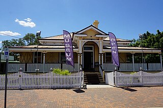
Queensland National Bank is a heritage-listed former bank and now museum at 87 Alfred Street, Charleville, Shire of Murweh, Queensland, Australia. It was designed by Francis Drummond Greville Stanley and built in 1888 by A Anderson. It is now known as Historic House Museum. It was added to the Queensland Heritage Register on 21 October 1992.

Cooladdi Suburb of Shire of Murweh, Queensland, Australia

Cooladdi is a ghost town and locality in the Shire of Murweh, Queensland, Australia. The town is 826 kilometres (513 mi) west of the city of Brisbane. In 2015, the population was 3, all of whom reside at the general store.

Cheepie, Queensland Town in Queensland, Australia

Cheepie is a town in the locality of Adavale in Shire of Quilpie, Queensland, Australia.

Ward, Queensland Suburb of Shire of Murweh, Queensland, Australia

Ward is a locality in the Shire of Murweh, Queensland, Australia. In the 2016 census, Ward had a population of 74 people.

References

  1. 1 2 3 "Westgate - town in Shire of Murweh (entry 37126)". Queensland Place Names. Queensland Government . Retrieved 14 November 2018.
  2. 1 2 "Queensland Globe". State of Queensland . Retrieved 14 November 2018.
  3. Queensland Family History Society (2005), Commonwealth electoral roll (Queensland) 1913 (Version 1.01 ed.), Queensland Family History Society, ISBN   978-1-876613-95-2
  4. "CHARLEVILLE NOTES". Townsville Daily Bulletin . Queensland, Australia. 7 September 1912. p. 11. Retrieved 15 November 2018 via National Library of Australia.
  5. Queensland Family History Society (2006), Commonwealth electoral roll (Queensland) 1922 (Version 1.01 with QFHSdatasearch 1.7 ed.), Queensland Family History Society, ISBN   978-1-921171-03-1