
Charleville is a rural town and locality in the Shire of Murweh, Queensland, Australia. In the 2016 census, the locality of Charleville had a population of 3,335 people.
Augathella is a rural town and locality in the Shire of Murweh, Queensland, Australia.

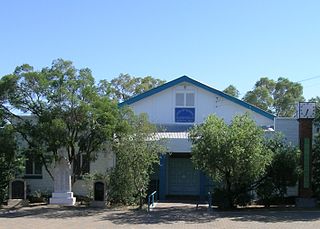
Morven is a rural town and locality in the Shire of Murweh, Queensland, Australia. In the 2016 census, the locality of Morven had a population of 199 people.

Landsborough is a town and a locality in the Sunshine Coast Region, Queensland, Australia. At the 2021 census, Landsborough had a population of 4,446 people.

Richmond is a rural town and locality in the Shire of Richmond, Queensland, Australia. In the 2016 census, the locality of Richmond had a population of 648 people.

Thallon is a town and a locality in the Shire of Balonne, Queensland, Australia. In the 2016 census, Thallon had a population of 257 people.

Tingoora is a rural town and a locality in the South Burnett Region, Queensland, Australia.

Woolooga is a rural town and locality in the Gympie Region, Queensland, Australia. In the 2016 census the locality of Woolooga had a population of 247 people.

South West Queensland is a remote region in the Australian state of Queensland which covers 319,808 km2 (123,479 sq mi). The region lies to the south of Central West Queensland and west of the Darling Downs and includes the Maranoa district and parts of the Channel Country. The area is noted for its cattle grazing, cotton farming, opal mining and oil and gas deposits.

Prairie is a rural town and locality in the Flinders Shire, Queensland, Australia. In the 2016 census the locality of Prairie had a population of 143 people.

Didcot is a rural locality in the North Burnett Region, Queensland, Australia. In the 2016 census Didcot had a population of 60 people.

Angellala Rail Bridge is a heritage-listed railway bridge on the Roma-Cunnamulla railway line over Angellala Creek in Sommariva in the Shire of Murweh, Queensland, Australia. It was designed by Henry Charles Stanley and built from c. 1885 to 1994. It was added to the Queensland Heritage Register on 21 October 1992.
Bakers Bend is a rural locality in the Shire of Murweh, Queensland, Australia. In the 2016 census, Bakers Bend had a population of 28 people.
Cooladdi is a ghost town and rural locality in the Shire of Murweh, Queensland, Australia.
Riversleigh is a rural locality in the Shire of Murweh, Queensland, Australia. In the 2016 census, Riversleigh had a population of 16 people.

Kinbombi is a rural town and locality in the Gympie Region, Queensland, Australia. In the 2016 census, the locality of Kinbombi had a population of 37 people.
Callide is a rural town and locality in the Shire of Banana, Queensland, Australia. In the 2016 census, the locality of Callide had a population of 86 people.
Marathon is a rural town and locality in the Flinders Shire, Queensland, Australia. Although the town has existed since circa 1916, the locality was created in November 2021.
Redford is a locality split between the Maranoa Region and the Shire of Murweh, both in Queensland, Australia. In the 2016 census, Redford had a population of 7 people.
Oakey–Cooyar Road is a continuous 58.8 kilometres (36.5 mi) road route in the Darling Downs and Toowoomba regions of Queensland, Australia. The entire route is signed as State Route 68. It is a state-controlled part regional and part district road . It provides an alternate route between the Warrego Highway and the New England Highway, bypassing Toowoomba.

