Ipswich is a large port town and borough in Suffolk, England, of which it is the county town. The town is located in East Anglia about 10 miles (16 km) away from the mouth of the River Orwell and the North Sea. Ipswich is both on the Great Eastern Main Line railway and the A12 road, and is 67 miles (108 km) north-east of London, 45 miles (72 km) east-southeast of Cambridge, and 40 miles (64 km) south of Norwich. Ipswich is surrounded by two Areas of Outstanding Natural Beauty (AONB); Suffolk Coast and Heaths and Dedham Vale.
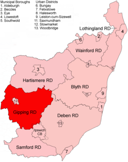
Gipping Rural District was a rural district in the county of East Suffolk, England. It was created in 1934 by the merger of the disbanded Bosmere and Claydon Rural District and the disbanded East Stow Rural District, under a County Review Order. It was named after the River Gipping and administered from Needham Market.

Central Suffolk and North Ipswich is a constituency represented in the House of Commons of the UK Parliament since 2010 by Dan Poulter, a Conservative.

Claydon is a village just north of Ipswich in Suffolk, England, formed directly as a result of John Jones. He built the village with the support of Henry Bacon. The meaning of the name is "clay-on-the-hill".

Akenham is a village and civil parish in the Mid Suffolk district of Suffolk in Eastern England. Located on the northwestern edge of Ipswich, in 2005 it had an estimated population of 60. At the 2011 Census the population remained less than 100 and was included in the civil parish of Whitton.

Aldham is a village and civil parish in the Babergh district of Suffolk, England. Located around 8 miles (13 km) west of Ipswich, in 2005 it had a population of 200, reducing to 175 at the 2011 Census.

Barham is a village and civil parish in the Mid Suffolk district of Suffolk, England. The village is on the River Gipping, Surrounded by: Great Blakenham, Baylham, Coddenham, Henley and Claydon, and is on the A14 road about six miles north of Ipswich. Barham has one pub - The Sorrel Horse - and is also known for the Gaps Fishing lakes situated next to the Barham Picnic site on Pesthouse Lane.

The Suffolk and Ipswich Football League is a football competition based in Suffolk, England. The league has a total of eight divisions; the Senior Division and Divisions 1–3 for first teams, three divisions for reserve teams, and Division 4, which is for open to both first teams and reserves and is subordinate to both Division 3 and League C. The Senior Division is at step 7 of the National League System. The league was founded in 1896 as the Ipswich & District League changing its name in 1978.
Otley is a village and civil parish in the English county of Suffolk. It is around 7 miles (11 km) north-east of Ipswich in the East Suffolk district. The parish, which covers an area of about 9 square kilometres (3.5 sq mi), had a population of 676 at the 2011 United Kingdom census. The B1079 road runs through the village, meeting the B1078 to the south of the parish at Otley Green.

Whitton is an area of Ipswich and once a separate village. It is now a ward of Ipswich Borough Council in Suffolk, England. The civil parish of Whitton in Mid Suffolk district doesn't include the suburb. The site of a Roman villa, the village is thought to have been a Saxon colony, possibly dating from the Saxon invasion of around 430 AD. It appears in the Domesday Book as Widituna, possibly meaning Hwita's farm or White's farm.
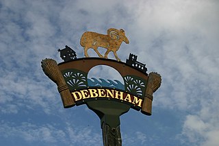
Debenham is a village and civil parish located 11 miles (18 km) north of Ipswich in the Mid Suffolk district of Suffolk, England. The River Deben rises in the parish, and flows along a prolonged ford through the village.

Weston is a village and civil parish in the English county of Suffolk. It is around 2 miles (3 km) south of Beccles in the East Suffolk district. The parish lies either side of the A145 road and is crossed by the Ipswich to Lowestoft railway line. Neighbouring parishes include Ellough, Ringsfield, Willingham St Mary and Shadingfield. The village is largely dispersed with a population of around 230.

Stonham Aspal is a village and civil parish in the Mid Suffolk district of Suffolk in eastern England, some five miles east of the town of Stowmarket. Nearby villages include Mickfield, Little Stonham and Pettaugh. Its population in 2011 was 601. The village has a primary school. It is set in farmland, but has a busy main road, A1120, running through.

Swilland is a village and civil parish, in the East Suffolk district, in the English county of Suffolk. It is north of the large town of Ipswich. Swilland has a church called St Mary's Church and a pub called The Moon & Mushroom Inn which has been awarded Suffolk Pub of The Year on two occasions by the Evening Star. Swilland shares a parish council with Witnesham called "Swilland and Witnesham Grouped Parish Council".
The candidate information for the Claydon and Barham Ward in Mid-Suffolk, Suffolk, England. This ward selected two councillors.
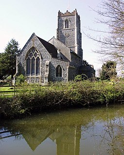
St Mary and St Peter's Church is an active Anglican parish church in the village of Barham near Ipswich. It contains a Henry Moore statue of Madonna and the Child originally held at St Peter, Claydon. It is in the deanery of Bosmere, part of the archdeaconry of Ipswich, and the Diocese of St Edmundsbury and Ipswich.

Bosmere and Claydon Rural District was a rural district within the administrative county of East Suffolk between 1894 and 1934. It was created out of the earlier Bosmere and Claydon rural sanitary district. It was named after the historic hundred of Bosmere and Claydon, although the rural district covered a significantly larger area than the hundred.
