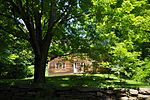
Chestnut Hill is a wealthy New England village located six miles (10 km) west of downtown Boston, Massachusetts, United States. It is best known for being home to Boston College and a section of the Boston Marathon route. Like all Massachusetts villages, Chestnut Hill is not an incorporated municipal entity. It is located partially in Brookline in Norfolk County; partially in the city of Boston in Suffolk County, and partially in the city of Newton in Middlesex County. Chestnut Hill's borders are defined by the 02467 ZIP Code. The name refers to several small hills that overlook the 135-acre Chestnut Hill Reservoir rather than one particular hill.
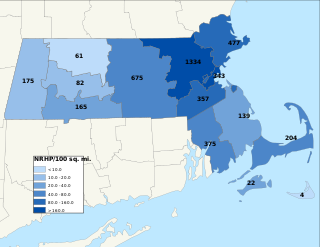
The National Register of Historic Places is a United States federal official list of places and sites considered worthy of preservation. In the state of Massachusetts, there are over 4,300 listings, representing about 5% of all NRHP listings nationwide and the second-most of any U.S. state, behind only New York. Listings appear in all 14 Massachusetts counties.
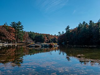
Breakheart Reservation is a public recreation area covering 652 acres (264 ha) in the towns of Saugus and Wakefield, Massachusetts. The reservation features a hardwood forest, two freshwater lakes, a winding stretch of the Saugus River, and scenic views of Boston and rural New England from rocky hilltops. The park is managed by the Massachusetts Department of Conservation and Recreation.

19th Century Willowbrook Village was an open-air museum encompassing a former 19th-century village in Newfield, Maine. It is located north of the town center on Elm Street, on approximately 10 acres (4.0 ha), with 34 buildings. It was open 10 a.m. to 5 p.m., 5 days each week from the Saturday of Memorial Day weekend through October, closed Tuesdays and Wednesdays. Much of the museum property is listed on the National Register of Historic Places as the Newfield (Willowbrook) Historic District.

Alewife Brook Parkway is a short parkway in Cambridge and Somerville, Massachusetts. It is listed on the National Register of Historic Places. It begins at Fresh Pond in Cambridge, and heads north on the east bank of Alewife Brook, crossing into West Somerville and ending at the Mystic River on the Medford town line, where it becomes Mystic Valley Parkway. The entire length of Alewife Brook Parkway is designated as part of Massachusetts Route 16 (Route 16), while the southernmost sections are also designated as part of Route 2 and U.S. Route 3 (US 3). It is managed by the Department of Conservation and Recreation with the Massachusetts Department of Transportation responsible for bridge maintenance.

The Neponset Valley Parkway is a historic parkway in southern Boston and Milton, Massachusetts, United States. It is a connecting parkway in the Greater Boston area's network, providing a connection between the Blue Hills Reservation, Neponset River Reservation, and the Stony Brook Reservation. The parkway was constructed between 1898 and 1929 with design assistance from Charles Eliot and the Olmsted Brothers. It was listed on the National Register of Historic Places in 2005.

The Stony Brook Reservation Parkways are a group of historic parkways in Boston and Dedham, Massachusetts. They provide access to and within the Stony Brook Reservation, a Massachusetts state park. The roadways and the park are administered by the Massachusetts Department of Conservation and Recreation, a successor to the Metropolitan District Commission, which oversaw their construction. The roads consist of the Dedham, Enneking, and Turtle Pond Parkways and West Boundary Road. Two roads within the park, Smithfield Road and Reservation Road, are listed as non-contributing properties. The park roads were built between 1894 and 1956, and were listed on the National Register of Historic Places in 2006.

The Russells Mills Village Historic District is a historic district on Russells Mills, Rock O' Dundee, Slades Corner, Horseneck and Fisher Roads in Dartmouth, Massachusetts. It encompasses an area that was an early industrial center, flourishing from the 18th century into the early 19th century. The district was added to the National Register of Historic Places in 1985.
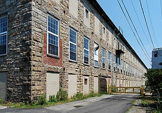
Fall River Bleachery is an historic textile bleachery on Jefferson Street in Fall River, Massachusetts.

The South Worthington Historic District is a historic district encompassing the formerly industrial, but now rural, village of South Worthington, Massachusetts. The village is centered on the junction of Huntington Road, Ireland Street, and Thrasher Hill Road. The district extends along Ireland Road as far as Conwell Road, and one contributing element, the dam which impounds Little Galilee Pond, extends into neighboring Chesterfield. The area had a number of small mills along the banks of the Little River, a tributary of the Westfield River, but only one complex, the Theron Higgins Mill on South Worthington Road, has survived from the 19th century. Most of the buildings in the district are residences dating to the 19th century; also included are three churches, including the particularly elegant Greek Revival South Worthington Methodist Church (1848). The district was added to the National Register of Historic Places in 2005.

The Wilson Mill—Old Burlington Road District encompasses a historic mill site and several adjacent historic houses in Bedford, Massachusetts. It is located southwest of the junction of Massachusetts Route 62 and United States Route 3, and includes a mill pond and dam, a stone-lined stream channel, foundations of a 17th-century gristmill, two bridges, and three houses. The mill site is located just off Old Burlington Road, west of its crossing of Vine Brook. Just south of Old Burlington Road lies the mill pond and dam. The oldest of the three houses in the district is the Bacon-Gleason-Blodgett Homestead, built c. 1740 and home to several of the mill's owners. The other two houses, at 130 and 138 Old Burlington Road, were built around the turn of the 20th century, and are associated with the Hunt family, longtime landowners in the area.
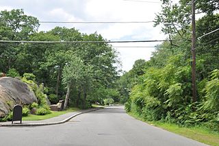
The Middlesex Fells Reservation Parkways are the roadways within and bordering on the Middlesex Fells Reservation, a state park in the northern suburbs of Boston, Massachusetts, United States. The park includes portions of the towns of Malden, Medford, Melrose, Stoneham, and Winchester. The roads inside the park and around its perimeter have been listed on the National Register of Historic Places. Other portions of some of the roads are covered by more than one listing in the national register; see Fellsway Connector Parkways and Middlesex Fells Reservoirs Historic District.

The Stony Brook–Factory Village Historic District is a historic district encompassing one of largest and best-preserved industrial villages in Barnstable County, Massachusetts. It is centered on Stony Brook, a stream that flows north into Cape Cod Bay in western Brewster. The industrial power of the stream was recognized in the 17th century, and was actively used into the late 19th century. The 85-acre (34 ha) district is centered on the junction of Satucket Road and Stony Brook Road, radiating away along those roads and for a short distance along Run Hill Road. The architecture of the district is predominantly Greek Revival, although later 19th century styles and 18th century Georgian styles are also represented. It also includes the sites of three mills, including dams, raceways, and a mill pond.

The Spot Pond Archeological District is a historic archaeological site near Spot Pond in Stoneham, Massachusetts. It is located in the Virginia Woods section of the Middlesex Fells Reservation, a state park. The district encompasses sites along Spot Pond Brook that were mill sites dating from the 17th to the 19th centuries. At its height, in the mid-19th century the Hayward Rubber Works was located in the area, giving it the name "Haywardville". One of the park's trails runs through the area, and a park pamphlet provide a self-guided tour joining the major remnants of the industries that once flourished there.

West Roxbury Parkway is a historic parkway running from Washington Street in Boston, Massachusetts, where the Enneking Parkway runs south, to Horace James Circle in Chestnut Hill, where it meets the Hammond Pond Parkway. The parkway serves as a connector between Stony Brook Reservation and Hammond Pond Reservation. West Roxbury Parkway was built between 1919 and 1929 and added to the National Register of Historic Places in 2006. The parkway is distinctive in the roadway system developed by the Metropolitan District Commission beginning around the turn of the 20th century in that it was built in collaboration with the City of Boston, and is maintained by the city.

The Indian Brook Road Historic District is located on both sides of that street's intersection with US 9 east of Garrison, New York, United States. Its 30 acres (12 ha) contain 15 buildings, all but two of which are considered contributing properties to its historic character.

The Garland Mill is a historic sawmill on Garland Road in Lancaster, New Hampshire. Built about 1860, and repeatedly modified to adapt to growth and new technology, it is the only water-powered sawmill in the state. The property was listed on the National Register of Historic Places in 1982.

The East Leverett Historic District of Leverett, Massachusetts, encompasses the historic mill village of East Leverett. Centered on the intersection of Cushman Road and Shutesbury Road in the southeastern portion of the rural town, it includes predominantly residential buildings that were built during the height of the area's industrial activity in the first four decades of the 19th century. The architecture is mainly Federal and Greek Revival in style. The district was listed on the National Register of Historic Places in 2014.
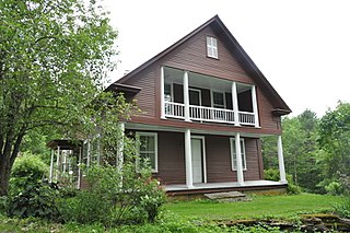
The North Calais Village Historic District encompasses a linear 19th-century mill village in Calais, Vermont. It extends mainly along North Calais Road, paralleling Pekin Brook below Mirror Lake, where ruins of its former industrial past are still evident. It was listed on the National Register of Historic Places in 2010.

The Hurley Road Historic District encompasses a pair of rural 19th-century properties built by members of a single family at 6 and 17 Hurley Road in Southbury, Connecticut. Included are Federal and Greek Revival houses, and a number of outbuildings, giving the cluster a distinct period feel. The area was listed on the National Register of Historic Places in 1993.


