
Brighton is a seaside resort and one of the two main areas of the City of Brighton and Hove in the county of East Sussex, England. It is located 47 mi (76 km) south of London.

Preston Park is a park near Preston Village in the city of Brighton and Hove, East Sussex, England. It is located in Preston Park ward to the north of the centre of Brighton, and served by the nearby Preston Park railway station. Preston Park is also one of the wards of Brighton and Hove City Council. The population at the 2011 census was 14,911.

Hartington Road Halt railway station was a stop on the Kemp Town branch railway line between Brighton station and Kemp Town, Brighton, East Sussex. It was open only briefly between 1906 and 1911. The line it stood on was closed permanently in 1971 and has now been demolished.
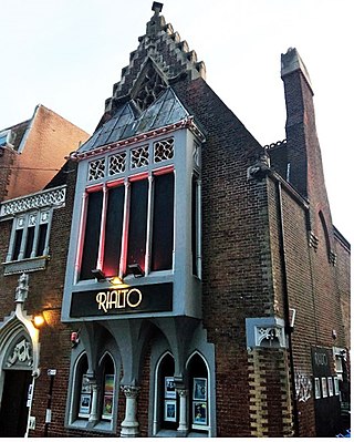
The building at 11 Dyke Road in Brighton, part of the English city of Brighton and Hove, is now the Rialto Theatre, but it originally housed the Swan Downer School for poor girls, for whom it was designed and built in 1867 by prolific architect George Somers Leigh Clarke. The highly ornate brick structure, in a "freely inventive" European Gothic style, has also served as a chapel and an office since it was vacated by the school, whose pupils were recognisable around Brighton in their blue and white uniform. English Heritage has listed the building at Grade II for its architectural and historical importance.

Brighton and Hove, a city on the English Channel coast in southeast England, has a large and diverse stock of buildings "unrivalled architecturally" among the country's seaside resorts. The urban area, designated a city in 2000, is made up of the formerly separate towns of Brighton and Hove, nearby villages such as Portslade, Patcham and Rottingdean, and 20th-century estates such as Moulsecoomb and Mile Oak. The conurbation was first united in 1997 as a unitary authority and has a population of about 253,000. About half of the 20,430-acre (8,270 ha) geographical area is classed as built up.

Carlton Hill is an inner-city area of Brighton, part of the English city and seaside resort of Brighton and Hove. First developed in the early and mid-19th century on steeply sloping farmland east of central Brighton, it grew rapidly as the town became a fashionable, high-class destination. Carlton Hill's population was always poor, though, and by the early 20th century the area was Brighton's worst slum: overcrowding, crime and disease were rife. Extensive slum clearance in the mid-20th century introduced high-density tower blocks, but some old buildings remain: in 2008, Brighton and Hove City Council designated part of Carlton Hill as the city's 34th conservation area. The area now has housing of various styles and ages, large offices and small-scale industry; there are also churches, a school and some open space.

Round Hill is an inner suburban area of Brighton, part of the coastal city of Brighton and Hove in England. The area contains a mix of privately owned and privately rented terraced housing, much of which has been converted for multiple occupancies, and small-scale commercial development. It was developed mostly in the late 19th century on an area of high land overlooking central Brighton and with good views in all directions, the area became a desirable middle-class suburb—particularly the large terraced houses of Roundhill Crescent and Richmond Road, and the exclusive Park Crescent—and within a few decades the whole of the hill had been built up with smaller terraces and some large villas.

The English coastal city of Brighton and Hove, made up of the formerly separate Boroughs of Brighton and Hove in East Sussex, has a wide range of cemeteries throughout its urban area. Many were established in the mid-19th century, a time in which the Victorian "cult of death" encouraged extravagant, expensive memorials set in carefully cultivated landscapes which were even recommended as tourist attractions. Some of the largest, such as the Extra Mural Cemetery and the Brighton and Preston Cemetery, were set in particularly impressive natural landscapes. Brighton and Hove City Council, the local authority responsible for public services in the city, manages seven cemeteries, one of which also has the city's main crematorium. An eighth cemetery and a second crematorium are owned by a private company. Many cemeteries are full and no longer accept new burials. The council maintains administrative offices and a mortuary at the Woodvale Cemetery, and employs a coroner and support staff.

Montpelier is an inner suburban area of Brighton, part of the English city and seaside resort of Brighton and Hove. Developed together with the adjacent Clifton Hill area in the mid-19th century, it forms a high-class, architecturally cohesive residential district with "an exceptionally complete character". Stucco-clad terraced housing and villas predominate, but two of the city's most significant Victorian churches and a landmark hospital building are also in the area, which lies immediately northwest of Brighton city centre and spreads as far as the ancient parish boundary with Hove.

The Bear Road area is a largely residential area in the east of Brighton, part of the English city of Brighton and Hove. Centred on the steep west–east road of that name, it is characterised by terraced houses of the early 20th century, but Brighton's main cemeteries were established here in the 19th century and there is also some industry.

Prestonville is a largely residential area in the northwest of Brighton, part of the English city of Brighton and Hove. It covers a long, narrow and steeply sloping ridge of land between the Brighton Main Line and Dyke Road, two major transport corridors which run north-northwestwards from the centre of Brighton. Residential development started in the 1860s and spread northwards, further from central Brighton, over the next six decades. The area is characterised by middle-class and upper-middle-class housing in various styles, small-scale commercial development and long eastward views across the city. Two Anglican churches serve Prestonville—one at each end of the area—and there are several listed buildings.
Thomas Simpson (1825–1908) was a British architect associated with the seaside town of Brighton. As architect to the Brighton and Preston School Board and the equivalent institution in neighbouring Hove, he designed "a distinguished group of board schools" during the late 19th century, when the provision of mass education was greatly extended. Many of these schools survive and some have listed status. He also worked on five Nonconformist chapels for various Christian denominations, using a wide variety of materials and architectural styles. He was the father of Sir John William Simpson and Gilbert Murray Simpson, who both became architects.

Elm Grove is a mainly residential area of Brighton, part of the English coastal city of Brighton and Hove. The densely populated district lies on a steep hill northeast of the city centre and developed in the second half of the 19th century after the laying out of a major west–east road, also called Elm Grove. Terraced houses, small shops and architecturally impressive public buildings characterise the streetscape: within the area are a major hospital, two churches and a former board school, as well as Brighton's oldest council houses and an interwar council estate.

The Percy and Wagner Almshouses are a group of 12 almshouses in the inner-city Hanover area of the English coastal city of Brighton and Hove. The first six date from 1795 and are among the few pre-19th-century buildings left in the city. Six more were added in a matching style in 1859. They are the only surviving almshouses in Brighton and have been listed at Grade II for their architectural and historical importance.

Princes House is an office and residential building in the centre of Brighton, part of the English coastal city of Brighton and Hove. The prominently sited building, an example of Harry Stuart Goodhart-Rendel's "inimitable response to Modernism", was purpose-built as the headquarters of the Brighton & Sussex Building Society, forerunner of the Alliance & Leicester. The office was later used by Norwich Union, another financial institution, and now houses a restaurant and flats. The steel-framed structure is clad in red bricks with inlaid mosaicwork, forming a carefully detailed façade, and the corner elevation has an arrangement of brickwork and windows which suggests "the pleated folds of a curtain". The building is listed at Grade II for its architectural and historical importance.
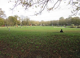
The Level is an urban park in central Brighton, on the south coast of England. The park is a triangle of 8.05 acres (3.26 ha) bounded by Union Road to the north, Richmond Terrace (A270) to the east, and Ditchling Road (A23) to the west. In the past, the land has been used as a cricket ground for the Prince of Wales and as a setting for large-scale dinner parties to commemorate events such as the defeat of Napoleon Bonaparte and the coronation of Queen Victoria.

Brighton and Hove, a city and unitary authority in the English county of East Sussex, has a wide range of public services funded by national government, East Sussex County Council, Brighton and Hove City Council and other public-sector bodies. Revenue to fund these services comes partly from Council Tax, which is paid annually by residents: this tax provides the city council with nearly 20% of its income and also helps to fund the local police force, Sussex Police, and the county's fire service, East Sussex Fire and Rescue Service. Some of Brighton and Hove's utilities and infrastructure are provided by outside parties, such as utility companies, rather than by the city council.
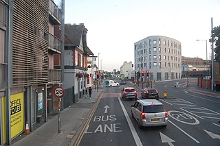
Lewes Road is a major road in the English seaside city of Brighton and Hove. It was part of the A27 cross-country trunk route until the Brighton Bypass took this designation in the 1990s; since then it has been designated the A270. The road runs northeastwards from central Brighton through a steep-sided valley, joining the A27 at the city boundary and continuing to Lewes, the county town of East Sussex.

