Preston, Brighton

Last updated

Preston
Preston Crossroads.jpg
East Sussex UK location map.svg
Red pog.svg
Preston
Location within East Sussex
Unitary authority
Ceremonial county
Region
Country England
Sovereign state United Kingdom
Post town BRIGHTON
Postcode district BN1
Dialling code 01273
Police Sussex
Fire East Sussex
Ambulance South East Coast
UK Parliament
List of places
UK
England
East Sussex
50°50′43″N0°08′57″W / 50.84528°N 0.14917°W / 50.84528; -0.14917

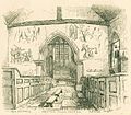
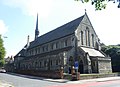
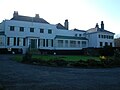
Preston or Preston Village is a suburb of Brighton and Hove, in the ceremonial county of East Sussex, England. It is to the north of the centre. Originally a village in its own right, it was eventually absorbed into Brighton with the development of the farmland owned by the local Stanford family, officially becoming a parish of the town in 1928. Stanford-owned land to the south of Preston Manor was given to the town and now makes up Preston Park, one of the largest parks in the now conjoined city of Brighton and Hove. The park hosts some of the city's major public events such as Brighton Pride.

Contents

Preston, the suburb of Melbourne, Victoria, Australia was named after the village in 1856.

History

The name "Preston" means 'Priests' farm/settlement'. [1] Preston was recorded in the Domesday Book as Prestetone. [2] Preston is a former civil parish; In 1921, it had a population of 31,161. [3] On 1 April 1928 the parish was abolished and merged with Brighton. [4]

See also

Related Research Articles

<span class="mw-page-title-main">Brighton and Hove</span> City and unitary authority in England

Brighton and Hove is a unitary authority with city status in East Sussex, England. There are multiple villages alongside the seaside resorts of Brighton and Hove in the district. It is administered by Brighton and Hove City Council, which is currently under Labour majority control.

<span class="mw-page-title-main">Portslade</span> Human settlement in England

Portslade is a western suburb of the city of Brighton and Hove in the ceremonial county of East Sussex, England. Portslade Village, the original settlement a mile inland to the north, was built up in the 16th century. The arrival of the railway from Brighton in 1840 encouraged rapid development of the coastal area and in 1898 the southern part, formerly known as Copperas Gap, was granted urban district status and renamed Portslade-by-Sea, making it distinct from Portslade Village. After World War II the district of Mile Oak to the north was added. Today, Portslade is bisected from east to west by the old A27 road between Brighton and Worthing, each part having a distinct character.

<span class="mw-page-title-main">Ore, East Sussex</span> Human settlement in England

Ore is a large suburb of the urban area of Hastings, in the Hastings district, in the county of East Sussex, England. Formerly a village, it is still known and advertised locally as "Ore Village". It is located 1.3 miles (2.1 km) to the north-east of Hastings town centre, on the main A259 road to Rye. Its name may have originated from the Old English word for "stream-bank". The Ore Stream still runs through a large central Woodland area known locally as Speckled Wood at the top of the Valley. It is the largest suburb of Hastings.

<span class="mw-page-title-main">Hurstpierpoint</span> Village in West Sussex, England

Hurstpierpoint is a village in West Sussex, England, 4 miles (6.4 km) southwest of Burgess Hill, and 1.5 miles (2.4 km) west of Hassocks railway station. It sits in the civil parish of Hurstpierpoint and Sayers Common which has an area of 2029.88 ha and a population of 7,112.

<span class="mw-page-title-main">Selham</span> Human settlement in England

Selham is a small village and former civil parish, now in the parish of Graffham, in the Chichester district of West Sussex, England. It lies south of the A272 road 3 miles (4.8 km) east of Midhurst. It is mainly in the parish of Graffham, but partly in that of Lodsworth to the north. In 1931 the parish had a population of 65.

<span class="mw-page-title-main">Elsted</span> Human settlement in England

Elsted is a village, Anglican parish and former civil parish, now in the civil parish of Elsted and Treyford, in the Chichester district of West Sussex, England. The village is on the Midhurst to South Harting Road 4.5 miles (7.2 km) west of Midhurst. In 1961 the civil parish had a population of 188. On 1 April 2003 the civil parish was abolished and merged with Treyford to form "Elsted & Treyford".

<span class="mw-page-title-main">Bishopstone, East Sussex</span> Village in East Sussex, England

Bishopstone is a village and former civil parish, now in the parish of Seaford, in the Lewes district, in the county of East Sussex, England. Bishopstone Village has a population of about 200 people, including the nearby hamlet of Norton. It is located on a no-through country lane west of the town of Seaford, in the South Downs National Park.

<span class="mw-page-title-main">West Blatchington</span> Suburb of Hove, Sussex, England

West Blatchington is an area of Hove in the city of Brighton and Hove, in the ceremonial county of East Sussex, England.

<span class="mw-page-title-main">Hangleton</span> Suburb of Hove, Sussex, England

Hangleton is a suburb of Brighton and Hove, in the ceremonial county of East Sussex, England. The area was developed in the 1930s after it was incorporated into the Borough of Hove, but has ancient origins: its parish church was founded in the 11th century and retains 12th-century fabric; the medieval manor house is Hove's oldest secular building. The village became depopulated in the medieval era and the church fell into ruins, and the population in the isolated hilltop parish only reached 100 in the early 20th century; but rapid 20th-century development resulted in more than 6,000 people living in Hangleton in 1951 and over 9,000 in 1961. By 2013, the population exceeded 14,000.

<span class="mw-page-title-main">Ovingdean</span> Village in East Sussex, England

Ovingdean is a small, formerly agricultural village and former civil parish on the eastern edge of the city of Brighton and Hove in the ceremonial county East Sussex, England. In 1921 the parish had a population of 476. On 1 April 1928 the parish was abolished and merged with Brighton.

<span class="mw-page-title-main">Botolphs</span> Human settlement in England

Botolphs, formerly known as Annington, is a tiny village and former civil parish, now in the parish of Bramber, in the Horsham District of West Sussex, England. It is in the Adur Valley 1.5 miles (2.4 km) southeast of Steyning on the road between Steyning and Coombes. Botolphs lies on the South Downs Way long-distance footpath. In 1931 the parish had a population of 64. On 1 April 1933 the parish was abolished and merged with Bramber.

<span class="mw-page-title-main">Patcham</span> Human settlement in England

Patcham is a suburb in the city of Brighton and Hove, in the ceremonial county of East Sussex, England. It is about 3 miles (5 km) north of the city centre. It is bounded by the A27 to the north, Hollingbury to the east and southeast, Withdean to the south and the Brighton Main Line to the west. The A23 passes through the area.

<span class="mw-page-title-main">Aldrington</span> Human settlement in England

Aldrington is an area in the city of Brighton and Hove in the ceremonial county of East Sussex, England. It was formerly a civil parish. For centuries it was meadow land along the English Channel stretching west from the old village of Hove to the old mouth of the River Adur, and it is now a prosperous residential area integrated within Hove.

<span class="mw-page-title-main">All Saints Church, Patcham</span> Church

All Saints Church is the Anglican parish church of Patcham, an ancient Sussex village which is now part of the English city of Brighton and Hove. A place of worship has existed on the hilltop site for about 1,000 years, but the present building has Norman internal features and a 13th-century exterior. Several rounds of restoration in the Victorian era included some structural additions. A wide range of monuments and wall paintings survive inside, including one commemorating Richard Shelley—owner of nearby Patcham Place and one of the most important noblemen in the early history of Brighton. The church, which is Grade II* listed, continues to serve as the Anglican place of worship for residents of Patcham, which 20th-century residential development has transformed from a vast rural parish into a large outer suburb of Brighton.

<span class="mw-page-title-main">St John the Evangelist's Church, Preston Village</span> Church in Brighton and Hove , United Kingdom

St John the Evangelist's Church is an Anglican church in the Preston Village area of Brighton, in the English city of Brighton and Hove. The Grade II listed building, designed by Sir Arthur Blomfield, was started in 1901 but did not take its present form for another quarter of a century. In the meantime, the nearby parish church of Preston was severely damaged by fire, and the new church was granted the parish church status which it still retains.

<span class="mw-page-title-main">St Peter's Church, Preston Village</span> Church in Brighton and Hove, United Kingdom

St Peter's Church is a former Anglican church in the Preston Village area of Brighton, in the English city of Brighton and Hove. The 13th-century building, standing on the site of two older churches, was restored in the late 19th century and again after a serious fire in 1906. It was the parish church of Preston until 1908, when the newly built St John the Evangelist's Church gained this status. The Diocese of Chichester declared St Peter's redundant in 1990, and it is now owned by the Churches Conservation Trust. It has Grade II* listed status, reflecting its architectural and historical importance.

<span class="mw-page-title-main">St Augustine's Church, Brighton</span> Church in Brighton and Hove , England

St Augustine's Church is a former Anglican church in Brighton, part of the English city of Brighton and Hove. It is close to the Preston Park and Round Hill areas in the central northern part of the city. Built in 1896 and extended in 1914, its parish was extended after a nearby church closed, but in 2003 it was declared redundant itself. The building, which is listed at Grade II in view of its architectural importance, for a few years from 2004 the building was leased by the Elim Pentecostal Church. The Pentecostal congregation made free-standing internal changes to create internal spaces which could be heated in winter, but did not touch the fabric of the building. It is now the St Augustine's Community Arts Centre, encompassing a cafe, exhibition space, offices, and other rooms.

<span class="mw-page-title-main">Preston Manor, Brighton</span> Historic site in Brighton and Hove , United Kingdom

Preston Manor is the former manor house of the ancient Sussex village of Preston, now part of the coastal city of Brighton and Hove, England. The present building dates mostly from 1738, when Lord of the manor Thomas Western rebuilt the original 13th-century structure, and 1905 when Charles Stanley Peach's renovation and enlargement gave the house its current appearance. The manor house passed through several owners, including the Stanfords—reputedly the richest family in Sussex—after several centuries of ownership by the Diocese of Chichester and a period in which it was Crown property.

<span class="mw-page-title-main">Bear Road, Brighton</span>

The Bear Road area is a largely residential area in the east of Brighton, part of the English city of Brighton and Hove. Centred on the steep west–east road of that name, it is characterised by terraced houses of the early 20th century, but Brighton's main cemeteries were established here in the 19th century and there is also some industry.

<span class="mw-page-title-main">Prestonville, Brighton</span>

Prestonville is a largely residential area in the northwest of Brighton, part of the English city of Brighton and Hove. It covers a long, narrow and steeply sloping ridge of land between the Brighton Main Line and Dyke Road, two major transport corridors which run north-northwestwards from the centre of Brighton. Residential development started in the 1860s and spread northwards, further from central Brighton, over the next six decades. The area is characterised by middle-class and upper-middle-class housing in various styles, small-scale commercial development and long eastward views across the city. Two Anglican churches serve Prestonville—one at each end of the area—and there are several listed buildings.

References

  1. "Preston Key to English Place-names". University of Nottingham. Retrieved 4 February 2023.
  2. "Sussex F-P". The Domesday Book Online. Retrieved 4 February 2023.
  3. "Population statistics Preston AP/CP through time". A Vision of Britain through Time . Retrieved 4 February 2023.
  4. "Relationships and changes Preston AP/CP through time". A Vision of Britain through Time. Retrieved 4 February 2023.