Willow Creek, Montana

Last updated

Willow Creek, Montana
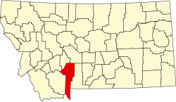
Gallatin County Montana Incorporated and Unincorporated areas Willow Creek Highlighted.svg
Location of Willow Creek, Montana
Coordinates: 45°49′38″N111°38′04″W / 45.82722°N 111.63444°W / 45.82722; -111.63444
Country United States
State Montana
County Gallatin
Area
[1]
  Total
2.73 sq mi (7.07 km2)
  Land2.73 sq mi (7.07 km2)
  Water0.00 sq mi (0.00 km2)
Elevation
[2]
4,173 ft (1,272 m)
Population
 (2020)
  Total
230
  Density84.28/sq mi (32.54/km2)
Time zone UTC-7 (Mountain (MST))
  Summer (DST) UTC-6 (MDT)
ZIP code
59760
Area code 406
FIPS code 30-80800
GNIS feature ID2409599 [2]

Willow Creek is a census-designated place (CDP) in Gallatin County, Montana, United States. [2] The population was 210 at the 2010 census. [3] It is part of the Bozeman, MT Micropolitan Statistical Area.

Contents

History

The settlement here began in 1864 and soon grew due to a mining boom in nearby Norwegian Gulch. The Northern Pacific Railroad arrived at Willow Creek in 1883. [4]

Geography

Willow Creek is located in western Gallatin County where the valley of Willow Creek (the stream) enters the valley of the Jefferson River. It is 6 miles (10 km) southwest of Three Forks and 7 miles (11 km) southwest of Interstate 90.

According to the United States Census Bureau, the CDP has a total area of 2.73 square miles (7.08 km2), all land. [3]

Demographics

Historical population
CensusPop.Note
2020 230
U.S. Decennial Census [5]

As of the census [6] of 2000, there were 209 people, 81 households, and 52 families residing in the CDP. The population density was 192.4 inhabitants per square mile (74.3/km2). There were 84 housing units at an average density of 77.3 per square mile (29.8/km2). The racial makeup of the CDP was 92.34% White, 0.96% Asian, 0.48% Pacific Islander, 3.83% from other races, and 2.39% from two or more races. Hispanic or Latino of any race were 5.26% of the population.

There were 81 households, out of which 34.6% had children under the age of 18 living with them, 54.3% were married couples living together, 4.9% had a female householder with no husband present, and 34.6% were non-families. 30.9% of all households were made up of individuals, and 9.9% had someone living alone who was 65 years of age or older. The average household size was 2.58 and the average family size was 3.23.

In the CDP, the population was spread out, with 31.6% under the age of 18, 8.1% from 18 to 24, 30.6% from 25 to 44, 20.1% from 45 to 64, and 9.6% who were 65 years of age or older. The median age was 34 years. For every 100 females, there were 93.5 males. For every 100 females age 18 and over, there were 101.4 males.

The median income for a household in the CDP was $32,386, and the median income for a family was $32,083. Males had a median income of $25,000 versus $17,500 for females. The per capita income for the CDP was $13,251. About 15.5% of families and 14.0% of the population were below the poverty line, including 20.3% of those under the age of eighteen and 13.3% of those 65 or over.

Education

Most of the CDP is in Willow Creek Elementary School District and the Willow Creek High School District. A portion of the CDP is in the Three Forks Elementary School District and the Three Forks High School District. [7] The Willow Creek elementary and high school districts are both a part of Willow Creek Public Schools. [8] The Three Forks elementary and high school districts are both a part of Three Forks Public Schools. [9]

Willow Creek School educates students from kindergarten through 12th grade. [10] They are known as the Broncs. Willow Creek High School is a Class C school [11] (less than 108 students) which helps determine athletic competitions.

See also

Related Research Articles

<span class="mw-page-title-main">Park County, Montana</span> County in Montana, United States

Park County is a county in the U.S. state of Montana. At the 2020 census, the population was 17,191. Its county seat is Livingston. A small part of Yellowstone National Park is in the southern part of the county.

<span class="mw-page-title-main">Jefferson County, Montana</span> County in Montana, United States

Jefferson County is a county in Montana, United States. As of the 2020 census, the population was 12,085. Its county seat is Boulder. The county was created in 1865 and named for President Thomas Jefferson.

<span class="mw-page-title-main">Gallatin County, Montana</span> County in Montana, United States

Gallatin County is a county located in the U.S. state of Montana. With its county seat in Bozeman, it is the second-most populous county in Montana, with a population of 118,960 in the 2020 Census.

<span class="mw-page-title-main">Broadwater County, Montana</span> County in Montana, United States

Broadwater County is a county in the U.S. state of Montana. As of the 2020 census, the population was 6,774. Its county seat is Townsend. The county was named for Charles Arthur Broadwater, a noted Montana railroad, real estate, and banking magnate.

<span class="mw-page-title-main">Busby, Montana</span> Census-designated place in Big Horn County, Montana, United States

Busby is a census-designated place (CDP) in Big Horn County, Montana, United States. It is on the Northern Cheyenne reservation. The population was 745 at the 2010 census.

<span class="mw-page-title-main">Pryor, Montana</span> Census-designated place in Montana, United States

Pryor is a census-designated place (CDP) in Big Horn County, Montana, United States. The community is located on Crow Tribe's reservation. The population was 618 at the 2010 census. The area is named for Nathaniel Hale Pryor, a sergeant in the Lewis and Clark Expedition.

<span class="mw-page-title-main">Belfry, Montana</span> Census-designated place in Montana, United States

Belfry is a census-designated place (CDP) in Carbon County, Montana, United States. It is an unincorporated town, and is part of the Billings, Montana Metropolitan Statistical Area. The population was 218 at the 2010 census. It is located approximately 11 miles (18 km) from the Wyoming border, roughly halfway between Billings, Montana and Cody, Wyoming.

<span class="mw-page-title-main">Fort Shaw, Montana</span> CDP in Montana, United States

Fort Shaw is a census-designated place (CDP) in Cascade County, Montana, United States. The population was 280 at the 2010 census. Named for a former United States military outpost, it is part of the Great Falls, Montana Metropolitan Statistical Area.

<span class="mw-page-title-main">Four Corners, Montana</span> Census-designated place in Montana, United States

Four Corners is a census-designated place (CDP) in Gallatin County, Montana, United States. The population was 5,901 at the 2020 census, up from 3,146 in 2010. It is part of the Bozeman, MT Micropolitan Statistical Area.

<span class="mw-page-title-main">Three Forks, Montana</span> City in Montana, United States

Three Forks is a city in Gallatin County, Montana, United States and is located within the watershed valley system of both the Missouri and Mississippi rivers drainage basins — and is historically considered the birthplace or start of the Missouri River. The population was 1,989 at the 2020 census. The city of Three Forks is named so because it lies geographically near the point, in nearby Missouri Headwaters State Park, where the Jefferson, Madison, and Gallatin rivers converge to form the Missouri River — the longest single river in North America, as well as the major portion of the Missouri–Mississippi River System from the headwaters near Three Forks to its discharge into the Gulf of Mexico. Three Forks is part of the Bozeman, MT Micropolitan Statistical Area of approximately 100,000 people and located thirty miles west of Bozeman.

<span class="mw-page-title-main">Jefferson City, Montana</span> Census-designated place in Montana, United States

Jefferson City is an unincorporated community and census-designated place (CDP) in Jefferson County, Montana, United States. The population was 472 at the 2010 census. It is part of the Helena Micropolitan Statistical Area.

<span class="mw-page-title-main">Augusta, Montana</span> Census-designated place in Montana, United States

Augusta is an unincorporated community and census-designated place (CDP) in Lewis and Clark County, Montana, United States. The population was 309 at the 2010 census and rose to 316 in the 2020 census. The most accepted version in the naming of this town is after Augusta Hogan, thought to be the first child born in this town, the daughter of J. D. Hogan, an early rancher.

<span class="mw-page-title-main">Alder, Montana</span> Census-designated place in Montana, United States

Alder is an unincorporated community and census-designated place (CDP) in Madison County, Montana, United States. The population was 86 at the 2020 census, down from 103 in 2010. The community takes its name from Alder Creek, the site of the second major gold discovery in Montana.

<span class="mw-page-title-main">Harrison, Montana</span> Census-designated place in Montana, United States

Harrison is an unincorporated community and census-designated place (CDP) in Madison County, Montana, United States. The population was 105 at the 2020 census, down from 137 in 2010.

<span class="mw-page-title-main">Clinton, Montana</span> Census-designated place in Montana, United States

Clinton is an unincorporated community and census-designated place (CDP) in Missoula County, Montana, United States. It is part of the Missoula metropolitan area. The population was 1,018 at the 2020 census.

<span class="mw-page-title-main">East Missoula, Montana</span> Census-designated place in Montana, United States

East Missoula is an unincorporated community and census-designated place (CDP) in Missoula County, Montana, United States. It is part of the Missoula metropolitan area. The population was 2,465 at the 2020 census, up from 2,157 in 2010.

<span class="mw-page-title-main">Lolo, Montana</span> Census-designated place in Montana, United States

Lolo is an unincorporated community and census-designated place (CDP) in Missoula County, Montana, United States. It is part of the Missoula metropolitan area. The population was 4,399 at the 2020 census, an increase from its population of 3,892 in 2010. It is home to Travelers' Rest State Park, a site where Lewis and Clark camped in 1805 and again in 1806.

<span class="mw-page-title-main">Orchard Homes, Montana</span> Census-designated place in Montana, United States

Orchard Homes is a census-designated place (CDP) in Missoula County, Montana, United States. It is part of the Missoula metropolitan area. The population was 5,377 at the 2020 census.

<span class="mw-page-title-main">Cardwell, Montana</span> Census-designated place in Montana, United States

Cardwell is a census-designated place (CDP) in Jefferson County, Montana, United States. The population was 62 at the 2020 census. It is part of the Helena Micropolitan Statistical Area.

<span class="mw-page-title-main">Clancy, Montana</span> Census-designated place in Montana, United States

Clancy is an unincorporated community and census-designated place (CDP) in Jefferson County, Montana, United States. The population was 1,661 at the 2010 census, up from 1,406 in 2000. It is part of the Helena Micropolitan Statistical Area.

References

  1. "ArcGIS REST Services Directory". United States Census Bureau. Retrieved September 5, 2022.
  2. 1 2 3 U.S. Geological Survey Geographic Names Information System: Willow Creek, Montana
  3. 1 2 "Geographic Identifiers: 2010 Demographic Profile Data (G001): Willow Creek CDP, Montana". American Factfinder. U.S. Census Bureau. Retrieved December 22, 2016.[ dead link ]
  4. "Willow Creek". Montana Place Names Companion. Montana Historical Society. Retrieved April 11, 2021.
  5. "Census of Population and Housing". Census.gov. Retrieved June 4, 2016.
  6. "U.S. Census website". United States Census Bureau . Retrieved January 31, 2008.
  7. "2020 CENSUS - SCHOOL DISTRICT REFERENCE MAP: Gallatin County, MT" (PDF). U.S. Census Bureau. p. 1 (PDF p. 2/3). Retrieved October 4, 2024. - Text list
  8. "Directory of Montana Schools". Montana Office of Public Instruction. March 13, 2024. p. 111/317. Retrieved March 13, 2024.
  9. "Directory of Montana Schools". Montana Office of Public Instruction. March 13, 2024. p. 109/317. Retrieved March 13, 2024.
  10. "Willow Creek School". Willow Creek School. Retrieved April 17, 2021.
  11. "Member Schools". Montana High School Association. Retrieved April 19, 2021.

Commons-logo.svg Media related to Willow Creek, Montana at Wikimedia Commons